Showing posts with label Norland. Show all posts

Sunday, 14 April 2024

St Luke's Church, Norland

Nestled in the heart of Norland village sits the charming little church known as St. Luke's. More than just a place of worship, St. Luke's boasts a rich history and serves as a vibrant hub for the local community.

St. Luke's was opened in April 1866 at a cost of approx £900. The Rev. John Ellison was instrumental in the decision to build what was then a Chapel of Ease for Christ Church in Sowerby Bridge. This quaint stone building, occupying a central position in the village has stood witness to the changing times of Norland. Early photographs depict a more rural setting, with the church surrounded by open fields.

St. Luke's welcomes everyone with open arms. Their website describes them as a "small and friendly church, and their commitment to inclusivity shines through. They hold services every Sunday afternoon, with an additional morning prayer on Mondays.

Stepping beyond traditional services, St. Luke's plays an active role in the community. Their website highlights a close relationship with the nearby Norland CE School. They also host the Hub Cafe, a wonderful space for people to connect and socialise. Additionally, they hold various events throughout the year, fostering a strong sense of community spirit.

Whether you're a local resident or simply curious about this historic church, St. Luke's offers several ways to get involved, with information easily available on their website.

So, if you're ever in the Sowerby Bridge area, take a moment to visit the charming little church on the hill. You might just discover a welcoming community and a beautiful piece of Norland's history.

The pictures below were taken on the 24th February 2024 with a Nikon d3300. They can also be seen in higher resolution on Clickasnap by clicking any image.

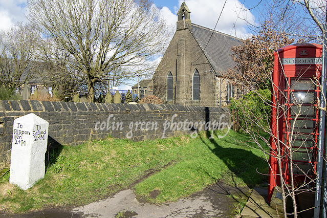
The church occupies a position at a cross roads in the centre of the village. The mileage marker showing the distance to Ripponden and Elland. The former phone box is now used as a village information point.

The south eastern corner of St Luke's, the war grave visible is the final resting place of Private Charles Albert Lumb, he served in the West Yorkshire Regiment until his death on the 21st August 1942 at the age of 28. He had been Married to Stella for just 4 years. His father had died at Ypres in October 1917.

Rusty gate at the eastern entrance to the churchyard. Private Lumb's headstone place again visible.


The church western gate is found opposite Norland Church of England Junior and Infant School.

Clicking any image should open a link in another window to the higher resolution image on Clickasnap. I regularly list images for sale on various prints and products are Photo4Me and my two Zazzle stores which can be seen via the links below. Please take a moment to have a look.

Thanks for looking, all the images remain the copyright of Colin Green.


Friday, 22 September 2023

Mearclough Bridge and the River Calder

 Mearclough Bridge is a crossing over the River Calder at Sowerby Bridge, West Yorkshire, the current bridge is the latest of a few that have provided a river crossing here connecting the historic townships of Norland and Warley who were separated by the river. Norland town was responsible for keeping the bridge in good repair and were fined for failing in this on the previous bridge, that bridge was replaced by the current crossing between 1774 and the turn of the 19th century.

The current bridge is a 3 arch stone built structure which now has traffic restrictions to prevent HGV crossing it. These preventions were enacted when the new Sterne Mills Bridge was constructed in the mid 2010's, prior to this the only access to the industrial units and recycling centre nearby were via the bridge and it was hit and damaged a number of times by vehicles crossing as the bridge is barely wider than a single track road with no pedestrian pavements. It was given Grade II listed status in 1988 and carries Fall Lane over the River Calder.

From the bridge looking east towards Sowerby Bridge centre is Mearclough Weir which is thought to have once powered Mearclough Mills which is said to have been a Corn Mill around it's construction in the early 1800's.

The pictures below were taken on the 5th November 2016 with a Nikon d3300.

The River Calder pictured from Mearclough Bridge, the former mill weir seen in the middle of the picture. Mearclough Mills were a chemical site by the turn of the 20th century and occupied land on both sides of the river. The mills were known as Triangle Mills by the 1930's and involved in photographic printing.

The River Calder again pictured from the bridge looking in the direction of Copley, To the left of the picture hidden by the trees is the Calder and Hebble Navigation, to the right again hidden by trees is a tow path that runs alngside the river to Sterne Mills Bridge.

Mearclough Bridge, the tunnel area just beyond the right arch was once the cellar of a dwelling that occupied the top corner of the structure. The Calder and Hebble Navigation is behind the wall a few feet higher than the river, there is a water overflow for the canal into the river to the right of the picture not shown.

Mearclough Bridge has 3 arches, the 2 larger ones pictured cross the water, a third one crosses waste ground now and is hidden by the trees to the left.

Clicking any image should open a link in another window to the un-watermarked, higher resolution version on Clickasnap.

thenks for looking, please take a moment to share and follow me on social media.

All the pictures remain the copyright of Colin Green.

Saturday, 16 December 2017

Unearthing the Whispers of Donkey Bridge

Nestled within the verdant embrace of Maple Dean Clough, near Norland, West Yorkshire, lies a silent sentinel of a bygone era: Donkey Bridge. More than just a simple crossing, this unassuming structure whispers tales of packhorse trains, arduous journeys, and the enduring spirit of the Pennine landscape.

Finding Donkey Bridge is a treasure hunt in itself. It's a secret passage, a hidden gateway between Copley and Norland, demanding a touch of adventurous spirit. From Copley, the ascent along North Dean Road, culminating in a sharp hairpin bend, marks the trailhead. A woodland path, beckoning towards Norland, conceals the bridge's approach. Alternatively, from Norland, the journey begins at the end of Pickwood Lane, where a steep, cobbled path, often obscured by nature's exuberance, plunges down to the clough.

This cloak of secrecy is part of Donkey Bridge's charm. In summer, a verdant tapestry of overgrowth conceals its details, creating an almost mystical atmosphere. Winter, however, transforms the path into a slippery, icy challenge, a testament to the harsh realities faced by those who traversed it centuries ago.

But Donkey Bridge is more than just a picturesque obstacle. It's a tangible link to the past, a surviving fragment of an ancient packhorse route that connected the villages of Copley and Norland, and served as a vital artery to larger settlements beyond. These routes, predating modern roads, were the lifelines of the region, facilitating trade and communication across the rugged terrain.

Imagine the scene: sturdy packhorses, laden with goods, their hooves echoing on the cobbled path, their breath clouding in the crisp Pennine air. These were the workhorses of their time, carrying everything from wool and textiles to essential supplies. The bridge, a crucial point in their journey, allowed them to safely navigate the challenging terrain of Maple Dean Clough.

While the modern wooden planks of Donkey Bridge offer a safe passage today, it's the ancient stone supports that truly capture the imagination. These weathered sentinels, shrouded in a cloak of moss and vegetation, speak of centuries of resilience. Their robust construction, despite the relentless passage of time and the harsh elements, testifies to the skill and craftsmanship of those who built them.

Delving deeper into the history, one can imagine the evolution of this crossing. For generations, a bridge has spanned this clough, adapting to changing needs and materials. The original stone supports, likely hewn from local gritstone, would have formed the bedrock of the crossing. Over time, the wooden elements, susceptible to decay, would have been repeatedly replaced, each iteration reflecting the prevailing techniques and resources.

The overgrown nature of the site adds another layer of intrigue. It allows us to glimpse the bridge as it might have appeared in less manicured times, when nature held greater sway. The moss-covered stones and the encroaching vegetation create a sense of timelessness, a feeling of stepping back into a forgotten era.

Visiting Donkey Bridge is more than just a walk in the woods. It's an opportunity to connect with the past, to trace the footsteps of those who came before us, and to appreciate the enduring beauty of the Pennine landscape. It's a reminder that even in our fast-paced world, there are still hidden gems waiting to be discovered, whispers of history waiting to be heard.

To truly appreciate Donkey Bridge, consider:

  • Exploring the surrounding landscape: Take time to explore the wider Maple Dean Clough, imagining the lives of those who lived and worked in this area.
  • Researching packhorse routes: Learn more about the history of packhorse trails in the Pennines and their significance to the region's development.
  • Visiting other historical sites: Combine your visit to Donkey Bridge with other historical sites in the area, such as the nearby villages of Copley and Norland, to gain a deeper understanding of the region's past.
  • Taking photographs: Capture the beauty and atmosphere of Donkey Bridge and its surroundings, preserving a record of your journey.
  • Visiting at different times of the year: See how the bridge and its surroundings change with the seasons, from the lush greenery of summer to the stark beauty of winter.

Donkey Bridge is a testament to the enduring power of history and the beauty of the natural world. By taking the time to explore this hidden gem, we can gain a deeper appreciation for the rich tapestry of our past and the enduring spirit of the Pennine landscape.

The total of 6 pictures were taken on the 8th March 2014 using a Polaroid is2132 Bridge Camera. Clicking any image should open a link in another window to my Colin Green Photography store on Zazzle.


Thanks for looking and please take a moment to share and follow me on social media and check out my portfolio on Photo4Me via the link below.


All the pictures remain the copyright of Colin Green.

Friday, 4 November 2016

Allan Park, Sowerby Bridge A Photographic Journey Through a Tranquil Setting.

 Allan Park is a hidden gem nestled near the heart of Sowerby Bridge. With its lush greenery, winding paths, and captivating views, it's no wonder this park has become a favourite amongst locals and photographers alike. Today, I'm taking you on a visual journey through Allan Park, sharing some of its hidden corners and capturing its unique blend of tranquility and history.

The moment you enter Allan Park, you're greeted by a canopy of towering trees, their leaves filtering the sunlight into a dappled mosaic. The air is filled with the sweet scent of blooming wildflowers and the gentle chirping of birds. As you wander along the paths, sunlight peeks through the leaves, illuminating patches of vibrant green moss blanketing the ground. It's a scene straight out of a fairytale, offering a welcome escape from the hustle and bustle of daily life.

Allan Park's history is woven into its very fabric. The Rishworth Branch Line Scar Head Tunnel, running directly beneath the park, adds a touch of industrial intrigue. The weathered stone bridge, a testament to the area's rich heritage, stands proudly against the backdrop of lush greenery. Capturing these historical elements alongside the park's natural beauty creates a visual dialogue between past and present, reminding us of the stories these spaces hold.

For photographers, Allan Park is a treasure trove of opportunities. From the delicate details of a spiderweb glistening with morning dew to the majestic silhouette of a tree against the setting sun, there's beauty to be found in every corner. Don't miss capturing the playful antics of squirrels scampering amongst the trees or the vibrant hues of wildflowers blooming in the meadows.

Whether you're seeking a peaceful escape, a spot for creative inspiration, or simply a chance to connect with nature, Allan Park has something to offer everyone. So, grab your camera, lace up your walking shoes, and embark on your own photographic adventure through this charming Sowerby Bridge
 haven.

These pictures were taken in May 2016 using a Nikon D3300 DSLR camera. Clicking any image below shouls open a link in another window to my Colin Green Photography store on Zazzle.


The tunnel portal is the entrance to Scar Head Tunnel. The tunnel runs for 542m underneath
Allan Park and was closed to railway traffic in 1958. Both sides of the tunnel are
partially blocked by industrial developments. This is the Sowerby Bridge
Station side.


Thanks for looking, and please take a moment to share and follow me on social media, and check out my portfolio on Photo4Me via the links below.
 

All links open in another window.

All the pictures remain the copyright of Colin Green.

Through a Glass, Darkly: Hebden Bridge Railway Station in Negative

 There's something hauntingly beautiful about old photographs, especially when they're presented in a way that flips our perception....