Monday, 4 October 2021

Dunkeswell Methodist Church and the Anglican Church of St Nicholas, Dunkeswell, Devon

 These pictures of the Methodist church and St Nicholas were taken on the 10th September 2015. I was at the nearby air field to collect a load in my job as a HGV driver and upon arrival was informed I would be unable to load until the following morning, so with time to pass and nothing to do I went to explore the local area.

Dunkeswell Methodist Church

The first church I passed whilst walking towards the village was the Dunkeswell Methodist Church, located a short walk from the airfield at the top of Abbey Road the small church overlooks the village. Other than service information there isn't much available online regarding the history of the church. The pictures below were taken using a Polaroid is2132 bridge camera and can also be seen full size, resolution and un-watermarked on Clickasnap.     

St Nicholas Church


The church of St Nicholas was rebuilt on the same site as an earlier structure between 1865-68, with the tower being replaced in 1953. The tower had been urgently demolished after World War II due to being seriously weakened and in danger of collapse. This structural damage had been caused by the engine vibration of the bombers taking off from the nearby air field which was home to the US Air Force and then the US Navy who have a plaque and book of remembrance in the church. The church still holds regular services today and has a number of references inside to the US forces that were stationed nearby.

The church was open when I passed so I got pictures of both the exterior and interior, they were taken using a Polaroid is2132 bridge camera. They can be seen below or alternatively on Clickasnap full size, resolution and un-watermarked.


Thanks for looking and please take a moment to share, all the pictures remain the copyright of Colin Green.


Thanks for looking and please take a moment to share and follow me on social media.

Clicking any image should open a link in another window to my Clickasnap profile.

All the images remain the copyright of Colin Green.

Saturday, 25 September 2021

Sowerby Bridge 2013

 2013 was the year I started to take an interest in photography whilst on a holiday to Lanzarote, and upon my return I started to venture around the area I live, this meant a lot of pictures of Sowerby Bridge as this is the place I called home.

Sowerby Bridge is a medium sized market town in Calderdale, West Yorkshire. The town grew around the confluence of the Rivers Calder and Ryburn where a fording point crossed the much larger River Calder and was eventually replaced by a bridge of which the town takes it's name. The towns largest growth was during the industrial revolution when the Rivers and the many streams, cloughs and water inlets helped power the textile and engineering mills which grew up along the banks. The town became an urban district in 1894 and was merged with Brighouse, Elland, Halifax, Hebden Bridge, and Todmorden to form the Metropolitan Borough of Calderdale in 1974.

Sowerby Bridge which grew around the Rivers Calder and Ryburn is also the junction point of the Calder and Hebble Navigation Canal which opened in 1770 and the Rochdale Canal, opened in 1804. The Calder and Hebble has remained open since completion, however the Rochdale Canal hasn't with closure of the canal in 1952, the last full journey from Sowerby Bridge having taken place in 1937. The section from Wharf Street to Bridge 1a Tower Hill was infilled and turned in to a new road, Tuel Lane and car park for the town. This section was reopened in 1996.

The railway reached Sowerby Bridge in 1840 when the first station to serve the town opened near to the present day Tesco superstore. This closed in 1876 when the current station opened it's present location. The stations move was in anticipation of the new Rishworth Branch Line opening.

The town declined when the textile and engineering companies left the area as the hilly nature and lack of flat land made it unsuitable for development. By the late 1970's the town was in serious decline with many industries, shops and business leaving, this led to various attempts at regeneration including a canoe club on the River Calder, restoration of the Rochdale Canal and canal wharf area, and large scale conversion of the former mills in to apartments or small industrial units more suitable for the area.

Sowerby Bridge whilst much improved since the 1980's still suffers from a lack of investment from Calderdale Council, the town suffering large traffic congestion problems, and a lack of shops that entice people to visit. The canals form a large centrepiece of the town and the annual Rushbearing festival brings much needed tourism to the town but these have been on the decline in recent years.

The pictures below were all taken around the town in 2013 and put together to form a YouTube video, they were taken using a Samsung Galaxy Tablet.


The pictures below all feature in the video and can be purchased from Clickasnap or Ebay.

Sowerby Bridge Station

The Canal Basin

Scar Head Tunnel Portal, on the closed Rishworth Branch Line.

Jubilee Refreshment Rooms, formerly Sowerby Bridge Station ticket office

The Subway at Sowerby Bridge Station. The bricked up portal used to run under long since removed lines and into the former station building which was damaged by fire and demolished around 1980.

Willow Hall Dam, this was taken on Boxing Day 2013, the bench is no longer their.

Winton Mill

The former Coal Drops

Willow Hall Dam

The Navigation Inn

The Rochdale Canal from Co-Op Bridge

The tunnel to the east of Sowerby Bridge is known by a few different names, the most popular being Dixy, Cemetery or Sowerby Tunnel. 

County Bridge, the bridge that gives the town it's name. A much older bridge can be seen underneath, which has been largely covered due to road widening.

Sowerby Bridge Cemetery

Carlton Mill Chimney

Clicking any image should open a link in another window to my Clickasnap profile.

Thanks for looking and please take a moment to share and follow me on social media.

All the pictures and video remain the copyright of Colin Green.

Saturday, 18 September 2021

Famous Scots in 2 Video Slideshows

 Famous Scots is a set of 2 videos I put together recently with a set of 50 cigarette trading cards I had in my possession from 1933. I was in the process of listing them for sale so took the time to scan and create 2 videos of 25 images each for YouTube.

The images feature poets, playwrights, inventors, politicians, royalty and much more. They can be seen below and on YouTube. please take a moment to subscribe to my channel.


and part 2,


The cards were released in packs of Mitchells Cigarettes which was a Scottish tobacco company based in Linlithgow, the company had merged with Imperial Tobacco by 1901 although the cards were released with Mitchells branding.

Thanks for looking and please take a moment to share.


Ibiza Sunsets

 Ibiza sunsets is small collection of pictures taken from the area around my hotel when visiting Ibiza in July 2014. The hotel was the Club Vista Bahia on the outskirts of Portinatx, Northern Ibiza and whilst the hotel was quite poor and I believe has now closed the views of the sunsets over the ocean made up for that.

The pictures below which can also be seen and purchased from Clickasnap were taken using a Polaroid is2132 bridge camera.


Clicking on any picture will take you to see the full size, resolution and un-watermarked version of the picture on Clickasnap.

Thanks for looking and please take a moment to share and follow me on social media.

All the pictures remain the copyright of Colin Green.

Saturday, 10 April 2021

The Nation's Shrine's (1929)

 The nation's Shrines is a short video I recently uploaded to YouTube featuring a collection of 25 cigarette trading cards from a collection released in 1929 called the nation's Shrines. Each card is an image of an historic place from either England, Ireland, Scotland and Wales and the complete set if featured in the video. They were released by Player's Cigarettes.


The images feature a number of abbey's, Cathedral's, Castle's and other places of interest in the United Kingdom. Sadly Kenilworth Castle is missing, the video software only aloud a brief glimpse of it between John Milton's cottage and Manorbier Castle. The pictures below are the ones that feature in the video. The break down of places represented is 17 sites from England, 3 from Wales and Ireland and 2 featured from Scotland. In this modern age i'm sure that split would be a bit more representative and certainly feature a few more sites of interest from the Celtic nations.

Ann Hathaway's Cottage, Warwickshire, England.

Blarney Castle, County Cork, Ireland.

Bootham Bar and York Minster, Yorkshire, England.

Cashel, County Tipperary, Ireland.

Clonmacnoise, County Offaly, Ireland.

Fountains Abbey, Yorkshire, England.

Furness Abbey, Cumbria, England

Glastonbury Abbey, Somerset, England.

Haddon Hall, Derbyshire, England.

Henry VIII's Chapel, Westminster Abbey, London, England.

Holyrood Palace, Edinburgh, Scotland.

John Knox's House, Edinburgh, Scotland.

Milton's Cottage, Buckinghamshire, England.

Kenilworth Castle, Warwickshire, England.

Manorbier Castle, Pembrokeshire, Wales.

Birthplace of William Shakespeare, Warwickshire, England.

St Davids Cathedral, Pembrokeshire, Wales

St Pauls Cathedral, London, England.

Stoke Poges Church, Buckinghamshire, England.

Stonehenge, Wiltshire, England.

The Cloisters at Newstead Abbey, Nottinghamshire, England.

Tower of London, London, England.

Tintern Abbey, Monmouthshire, Wales.

Warwick Castle, Warwickshire, England.

Winchester Cathedral, Hampshire, England.

Clicking any image should open a link in another window to my Clickasnap profile.

Thanks for looking and please take a moment to share and follow me on social media.

Monday, 5 April 2021

Churn Milk Joan, A Moorland Mystery

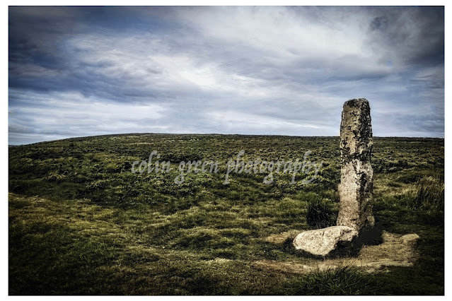
Standing sentinel on Midgley Moor, overlooking the breathtaking Calder Valley, is a stone steeped in history and legend. Known by many names – Churn Milk Joan, Churn Milk Peg, and Nelmires Stoop – this imposing 7ft monolith has watched over the valley for centuries, its origins shrouded in time.

First recorded in the 17th century, the stone is believed to have served as a boundary marker, a silent witness to the ebb and flow of life across the moors. But its more colourful name, Churn Milk Joan, didn't appear until the early 1800s, and with it came a tale as chilling as the moorland wind.

Local legend whispers of a milkmaid, caught in a ferocious snowstorm, who tragically froze to death while crossing the treacherous moor from Peckett Well to Luddenden. They say the stone was named in her memory, a poignant reminder of the harsh beauty and unforgiving nature of the landscape.

But Churn Milk Joan isn't just a monument to tragedy. It's also a source of local folklore and superstition. Legend has it that placing a penny in the hollow atop the stone will bring you good luck. And if you're brave enough to venture to the moor on New Year's Eve, you might witness a truly magical spectacle. They say that as the bells of St. Michael's Church in Mytholmroyd echo across the valley, the stone itself spins three times! A captivating thought, especially considering the stone predates the church by a couple of hundred years. What secrets has it witnessed in its long vigil?

So, the next time you find yourself exploring the Calder Valley, take a detour to visit Churn Milk Joan. Stand in its shadow, feel the wind whipping across the moor, and let your imagination wander. Is it just a boundary marker? A memorial to a lost milkmaid? Or a magical stone with the power to grant good fortune? Perhaps it's a little bit of all three, a testament to the rich tapestry of history and folklore woven into the very fabric of the Yorkshire landscape.

The picture was taken on the 5th April 2021.

Clicking the image should open a link in another window to the un-watermarked, higher resolution version on Clickasnap.

Thanks for looking, please take a moment to share and follow me on social media.

Saturday, 13 March 2021

Eads Bridge Disaster and Outdoor Games at the Organ Festival.

I am currently working through my collection of pictures and postcards I have purchased and slowly posting about them here. Due to the current lockdown restrictions around Corona in the UK I have not been able to get out much with my own Camera.

The first one was in a sleeve with the note St Louis and Illinois Bridge disaster. Eads Bridge. 

The 2nd picture featured today was titles "Outdoor Games at the Organ Festival" and was taken in Sweden during the 1920's

Sadly other than the notes on the sleeve I am unable to provide any more information.  Thanks for looking and please take a moment to share and follow me on social media.

Clicking any image should open a link in another window to my Clickasnap profile.

Through a Glass, Darkly: Hebden Bridge Railway Station in Negative

 There's something hauntingly beautiful about old photographs, especially when they're presented in a way that flips our perception....