Showing posts with label Landmark. Show all posts

Thursday, 14 November 2024

Copley Bridge: A Lost Landmark

 The historic Copley River Bridge, a graceful two-arch stone structure, once spanned the River Calder, carrying North Dean Road across its waters. Built in 1831 by Richard Kennett-Dawson, the last Lord of the Manor of Copley, the bridge was a significant local landmark.

For many years, a toll was charged to cross the bridge, a practice that ended in 1856. The bridge stood for 184 years, weathering the passage of time and serving as a vital connection for the community.

However, the bridge's legacy was tragically cut short. The devastating Boxing Day floods of 2015 wreaked havoc on the Calder Valley, leaving the bridge severely damaged. Despite efforts to repair it, the extent of the damage necessitated its demolition.

In 2017, a modern replacement, a single-span steel bridge, was constructed and opened. To honor the memory of Graham Wilson, a long time resident of the tollhouse who passed away that same year, the new bridge was named the Wilson Bridge.

Though the historic Copley River Bridge is no longer with us, its memory lives on, a reminder of the region's rich history and the enduring power of nature.

The former Copley Toll Booth, a quaint building dating back to around 1831, still stands today. Originally situated at the end of the old stone bridge, it now serves as a private residence south of the Wilson Bridge.

I took these pictures on the 1st February 2014 with a Polaroid is2132.


Discover my world of art and photography on Zazzle and photo4Me! Explore my curated collections and find the perfect piece to bring your space to life. From Stunning wall art to unique merchandise, there's something for everyone, and with Zazzle's customisation options, you can personalise your favourite image to match your style and create a truly one of a kind piece.

Click any picture below to open a link to the store you require, all links open in another window.


Copies of all my images shown here in my blog will be shortly available as prints on my Colin Green Photography Zazzle store. They can be reached via clicking on the images below.


Whilst these are currently being offered as 6x4 photo prints on Zazzle, all my images can be added to multiple products of your choosing, from wall art to tapestries, postcards to clocks and edited using Zazzle's customization tools.

All the images remain the copyright of Colin Green.

Wednesday, 13 November 2024

The Halifax Gibbet: A Gruesome Chapter in History

 Imagine a time when justice was swift and often brutal. A time when a simple theft could lead to a gruesome public execution. Welcome to the chilling world of the Halifax Gibbet, a medieval guillotine that once loomed over the English town of Halifax.

A Legacy of Fear

First used in the 13th century, the Halifax Gibbet was a stark reminder of the consequences of breaking the law. Over the next 400 years, it claimed the lives of 52 known individuals, and up to 100, including women and children. The condemned were often executed for petty crimes, such as stealing cloth or livestock.

A Gruesome Execution

The execution process was as terrifying as it was efficient. The condemned would be placed on a platform, their neck positioned beneath the heavy, blunt blade. A cord would be pulled, releasing the blade, which would swiftly sever the victim's head.

Escaping the Blade

However, there was a glimmer of hope for the condemned. If a victim could manage to escape the immediate vicinity of the gibbet, specifically across the nearby Hebble Brook, they could avoid execution. This daring escape was attempted by a few, including the infamous "Running Man," John Lacey. Unfortunately, Lacey's luck ran out, and he was eventually captured and executed.

The End of an Era

The Halifax Gibbet was finally outlawed by Oliver Cromwell in 1650. The last victims of this gruesome device were Anthony Mitchell and Abraham Wilkinson, who were executed on April 30th of that year.

A Dark Past, A Haunting Legacy

Today, the site of the Halifax Gibbet stands as a chilling reminder of a bygone era. A replica of the guillotine has been erected, allowing visitors to appreciate the brutality of this dark chapter in history. The original blade, now preserved in the Bankfield museum, serves as a chilling artifact of the past.

I took these pictures on the 27th March 2019 with a Nikon d3300, they can be seen in a higher resolution on Clickasnap.


Discover my world of art and photography on Zazzle and photo4Me! Explore my curated collections and find the perfect piece to bring your space to life. From Stunning wall art to unique merchandise, there's something for everyone, and with Zazzle's customisation options, you can personalise your favourite image to match your style and create a truly one of a kind piece.

Click any picture below to open a link to the store you require.


All links will open in another window and all the images remain the copyright of Colin Green.

Sunday, 28 January 2024

Stoodley Pike November 2016

Towering over the Calder Valley, Stoodley Pike is more than just a hill overlooking the town of Todmorden, West Yorkshire; it's a monument; it's a beacon, a challenge, and a gateway to breathtaking panoramas. I embarked on my own Stoodley Pike adventure, and let me tell you, it was an experience in stunning vistas.

There are several routes to the summit, each offering its own unique charm. I opted for the Shaw Wood Road trail, starting from the A646 Burnley Road. The trail leaves Burnley Road almost immediately, crossing over the Rochdale Canal alongside Lock No. 15 Shawplains. The road winds through woodlands before reaching a housing estate at Lee Bottom Road, which runs eastward, offering glimpses of the imposing Pike as you ascend. Be prepared for a good workout, as the trail steadily gains elevation.

Finally, after conquering the final incline, the reward arrives. The 39-step spiral staircase beckons, leading you up another 40 feet to the balcony of the monument. Remember, a torch is recommended, as the narrow passage plunges into darkness, despite a grill that is meant to offer a light source.

The views from the top are nothing short of magnificent. The hill, at a height of 1300 feet, shows rolling fields in every direction, dotted with villages, reservoirs, and the distant Pennine peaks. On a clear day, you can even see Manchester and the Irish Sea! Take a deep breath, soak it all in, and feel the sense of accomplishment wash over you.

But Stoodley Pike is more than just a scenic overlook. It's steeped in history, dating back to the Iron Age. Explore the monument's intriguing inscriptions and weathered stones, whispering tales of the past. A monument was originally built to commemorate the Napoleonic Wars and then rebuilt to remember the Crimean War.

The monument features the following faded inscription above the north facing door:

STOODLEY PIKE
A BEACON MONUMENT
ERECTED BY PUBLIC SUBSCRIPTION
COMMENCED IN 1814 TO COMMEMORATE
THE SURRENDER OF PARIS TO THE ALLIES
AND FINISHED AFTER THE BATTLE OF
WATERLOO WHEN PEACE WAS ESTABLISHED IN 1815.
BY A STRANGE COINCIDENCE
THE PIKE FELL ON THE DAY THE RUSSIAN
AMBASSADOR LEFT LONDON BEFORE THE
DECLARATION OF WAR WITH RUSSIA IN 1854.
WAS REBUILT WHEN PEACE WAS RESTORED IN
1856.
RESTORED AND LIGHTNING CONDUCTOR FIXED IN
1889.
 
The pictures below were taken on the 19th November 2016 with a Nikon D3300; they can be seen un-watermarked on my Clickasnap portfolio. Click any image to view it there.

The path up to Stoodley Pike, the monument visible at the summit.

I think the snow clinging to the side of the structure gives the monument a completely different feel to its usual look.


The Calder Valley and beyond towards Lancashire, taken from the base of the monument.

Looking west away from the monument, I have always liked this picture as it's gives the impression the clouds will shortly fall over the edge of the hill.

Thanks for looking, please take a moment to share and follow me on social media, you can also check out my Zazzle stores and Photo4Me portfolio via the links below.


All the pictures remain the copyright of Colin Green.

Friday, 6 May 2022

Middlesborough Transporter Bridge

The Tees Transporter Bridge by it's given name is the longest remaining transporter bridge in the world, currently closed and in need of repairs the bridge seems to have a somewhat uncertain future.

Built at a cost of over £68000, the bridge replaced the ferry service that crossed the Tees nearby when opened in October 1911. A transporter bridge was chosen so as not to effect shipping navigating the River Tees upstream and when the bridge was constructed it was red, the bridge only adopting its blue colour in 1961.

The Transporter Bridge was granted Grade II listed status on the 21 June 1985, and the Heritage Plaque from the Institution of Mechanical Engineer's in December 1993. The bridge was closed for works in August 2019 and has remained closed since on safety grounds.

The pictures below are original artworks created by me and based on drone footage of the bridge.


Clicking on either picture will open a link in another window to the higher resolution, un-watermarked version on Clickasnap.

Thanks for looking and please take a moment to share and follow me on social media.

All the pictures remain the copyright of Colin Green.

Saturday, 26 March 2022

Churn Milk Joan Artwork

 I previously posted the picture Churn Milk Joan in April 2021 and provided the following information alongside it,

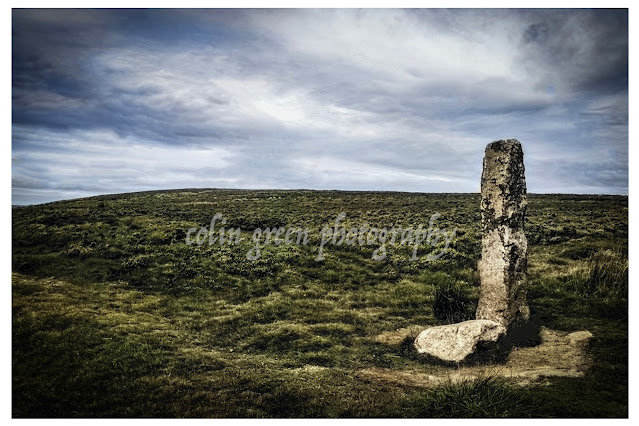
Churn Milk Joan is a standing stone upon Midgley Moor overlooking the Calder Valley. Also Known as Churn Milk Peg and Nelmires Stoop it reaches a height of approx 7ft and is thought to have been erected as a boundary marker, having been recorded as early as the 17th Century.

The stone is thought to have been given the name Churn Milk Joan in the early 19th Century, as a tribute to a milkmaid who froze to death whilst crossing the moor from Peckett Well to Luddenden during a heavy snow storm. Some of the legends said about the stone include leaving a penny in the depression on top of the stone is said to bring you good luck, it is also claimed that the stone spins 3 times on New Years Eve when the sound of the St Michaels Church bells, Mytholmroyd can be heard around it, the stone is thought to predate the church by a couple of hundred years.

Clicking the image should open a link in another window to the un-watermarked, higher resolution version on Clickasnap.

Thanks for looking, please take a moment to share and follow me on social media.

Monday, 5 April 2021

Churn Milk Joan, A Moorland Mystery

Standing sentinel on Midgley Moor, overlooking the breathtaking Calder Valley, is a stone steeped in history and legend. Known by many names – Churn Milk Joan, Churn Milk Peg, and Nelmires Stoop – this imposing 7ft monolith has watched over the valley for centuries, its origins shrouded in time.

First recorded in the 17th century, the stone is believed to have served as a boundary marker, a silent witness to the ebb and flow of life across the moors. But its more colourful name, Churn Milk Joan, didn't appear until the early 1800s, and with it came a tale as chilling as the moorland wind.

Local legend whispers of a milkmaid, caught in a ferocious snowstorm, who tragically froze to death while crossing the treacherous moor from Peckett Well to Luddenden. They say the stone was named in her memory, a poignant reminder of the harsh beauty and unforgiving nature of the landscape.

But Churn Milk Joan isn't just a monument to tragedy. It's also a source of local folklore and superstition. Legend has it that placing a penny in the hollow atop the stone will bring you good luck. And if you're brave enough to venture to the moor on New Year's Eve, you might witness a truly magical spectacle. They say that as the bells of St. Michael's Church in Mytholmroyd echo across the valley, the stone itself spins three times! A captivating thought, especially considering the stone predates the church by a couple of hundred years. What secrets has it witnessed in its long vigil?

So, the next time you find yourself exploring the Calder Valley, take a detour to visit Churn Milk Joan. Stand in its shadow, feel the wind whipping across the moor, and let your imagination wander. Is it just a boundary marker? A memorial to a lost milkmaid? Or a magical stone with the power to grant good fortune? Perhaps it's a little bit of all three, a testament to the rich tapestry of history and folklore woven into the very fabric of the Yorkshire landscape.

The picture was taken on the 5th April 2021.

Clicking the image should open a link in another window to the un-watermarked, higher resolution version on Clickasnap.

Thanks for looking, please take a moment to share and follow me on social media.

Through a Glass, Darkly: Hebden Bridge Railway Station in Negative

 There's something hauntingly beautiful about old photographs, especially when they're presented in a way that flips our perception....