Showing posts with label Flooding. Show all posts

Monday, 25 August 2025

November 2015: When the Calder Roared in Sowerby Bridge

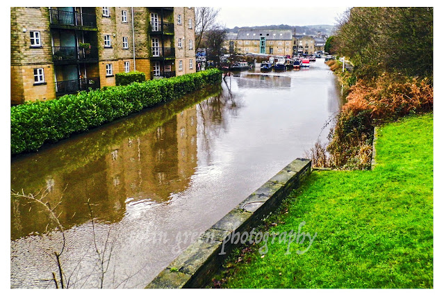
The air in Sowerby Bridge felt different in November 2015. It was a time of unease, a prelude to a significant weather event that would forever be etched in the memories of those who lived there. These sepia-toned images, with their soft, melancholic feel, capture that moment of heightened tension, a time when the River Calder was not the familiar, tranquil waterway but a powerful, surging force.

Standing at Mearclough Bridge, the first thing that strikes you is the sheer volume and speed of the water. It's a churning, brown torrent, consuming its banks and threatening to reclaim the land it once sculpted. The normally visible riverbed is now a distant memory, and the water level has risen ominously high against the old mill building, its submerged windows like dark, gaping eyes. The sepia filter, far from diminishing the drama, adds a sense of timelessness, as if this isn't just a recent event but a recurring story in the valley's history. The leafless trees, with their stark, skeletal branches, seem to echo the stark reality of the rising water, a silent witness to the river's power.

Further upstream, at the Gas Works Bridge, the landscape presents a similar, unsettling picture. The river, viewed from the pedestrian bridge, fills the entire width of the valley. The usual calm flow has been replaced by a relentless, turbulent rush. In the distance, the iconic chimney on the hillside stands like a lonely sentinel, a silent observer of the unfolding drama. The sepia tone lends a painterly quality to the scene, highlighting the textures of the water and the silhouette of the trees against the grey, moody sky.

Looking towards the bridge itself, the images reveal the water lapping dangerously high against its stone arches. It’s a testament to the bridge's enduring strength and the skill of its builders that it stands firm against such pressure. The river, a character in its own right, is asserting its dominance, forcing us to remember that we are guests in its valley, and it is a powerful host.

These photographs are more than just records of a flood. They are a poignant reminder of the vulnerability and resilience of our communities. They speak of the raw power of nature and the way it can transform the familiar into something alien and threatening. They capture the quiet suspense of a town waiting, a community holding its breath before the events of December would truly test its mettle. These images, softened by time and the sepia filter, are a beautiful and haunting chronicle of a turbulent November in Sowerby Bridge.

I took these pictures on the 15th November 2015, approx. 6 weeks before the Calder Valley was devastated by flooding. They were taken with a Polaroid is2132 camera.

Clicking any of the images should open a link in another window to my Colin Green Photography store on Zazzle.


Please take a moment to share this post, follow me on social media, and explore my work on Clickasnap and Photo4Me using the links below. Your Support means a lot!


All the images remain the copyright of Colin Green.

Saturday, 8 October 2022

Remembering the Deluge: Sowerby Bridge and the 2015 Boxing Day Floods

 The Boxing Day floods of 2015 are etched into the memory of the Calder Valley. On that day, a perfect storm of relentless rainfall and already-saturated ground caused the River Calder and its tributaries to swell, bursting their banks and unleashing a wave of devastation. While towns like Mytholmroyd and Hebden Bridge were hit harder, Sowerby Bridge didn't escape the deluge. These images, rediscovered and shared, offer a powerful, on-the-ground look at the impact of the floods on our community.


A Town Submerged

The photos, taken with a Polaroid is2132 bridge camera, serve as a stark reminder of the sheer force of nature. One image shows the River Calder surging near the Turks Head Footbridge, its muddy waters completely overwhelming the usual banks. What is normally a peaceful river is transformed into a raging torrent, encroaching on picnic tables and threatening nearby buildings.

The sheer volume of water is evident in another photo, where the river completely surrounds the Lockhart Mills complex. The water level is so high it nearly reaches the windows on the ground floor, illustrating the scale of the damage. At the Gas Works Bridge, the river's high water levels are captured from two different angles, showing the water's menacing rise, swallowing trees and reaching the very edge of the footbridge.


The Unstoppable Flow

The flooding wasn't limited to the river alone. The Calder and Hebble Navigation canal system, a vital part of Sowerby Bridge's heritage, also succumbed to the pressure. Photos of Tuel Lane Lock show water cascading over the lock gates, an unsettling reversal of its typical function. The lock, designed to manage water flow, was completely overwhelmed, highlighting the extraordinary volume of rain that fell.

The images of the canal near Kirkham Turn and the Calder & Hebble Navigation show the water level rising to meet the surrounding land, turning the waterway into a vast, muddy lake. Houseboats, usually resting serenely, are caught in the swirling currents, their moorings tested by the floodwaters.


A Community's Resilience

While these pictures document the physical devastation, they also implicitly tell a story of resilience. The 2015 floods were the worst to hit the area since the 1960s, causing millions of pounds in property damage. Yet, from this shared hardship emerged an incredible community spirit. Neighbours helped neighbours, businesses were rebuilt, and the community came together to clean up the aftermath.

These photographs are more than just records of a flood; they are a testament to the power of nature and the enduring strength of the people who call the Calder Valley home. They remind us to respect our environment and to remember the challenges we have faced and overcome together.

The flooded Calder & Hebble Navigation and Rochdale Canals from Chain Bridge.

The Calder & Hebble overflowing at Chain Bridge.

Rochdale Canal from Tower Hill Bridge. The towpath can normally be seen to the
right of the canal, the small wall probably prevented the car park and nearby town
centre from further damage.

Tuel Lane Lock gates flowing over.

The River Calder flowing past Kingfisher Chase towards Lockhart Mills. The levels is
normally 15 - 20ft lower than this.

The flooded Kirkham Turn. This is where the Rochdale canal joins the Calder &
Hebble Navigation.

Flooding at Tuel Lane Lock on the Rochdale Canal.

Very High River Calder flowing past the Weaving Shed Apartments (right of picture) and
Dugdales Mill left of picture. Dugdales was severely flooded during this event.

River Calder at Gas Works Bridge, considering the damage done to Cromwell, Copley and
Elland Bridges, I was surprised that Gas Works Bridge still stood after the floods.

River Calder at Gas Works Bridge, looking more like a dam head than river crossing.

High level River Calder at Lockhill Mill, much of the red brick building was damaged beyond
repair by the flood and demolished the year after.

River Calder from above the Turks Head Beer Garden, the lower half of the iron footbridge
was just in to the flooded area. Dugdales mill storage yard can be seen heavily
flooded in the background.

Please take a moment to share this post, follow me on social media, and explore my work on Clickasnap and Photo4Me using the links below. Your support means a lot!


All the pictures remain the copyright of Colin Green.

Sunday, 1 December 2019

Experience the Magic of Venice: A New Video Journey!

Get ready to be transported to the enchanting canals and historic piazzas of Italy's most unique city! I'm thrilled to announce my latest YouTube upload: "A Trip to Venice."

This captivating video, approximately 2.5 minutes long, is a curated collection of scenes I captured during my few days exploring Venice at the end of October and beginning of November 2018. From the moment you hit play, you'll glide along the iconic Grand Canal on a mesmerizing boat trip, witnessing the city's grandeur from its watery arteries.

The video also takes you through the bustling and magnificent St. Mark's area, showcasing its architectural wonders and vibrant atmosphere. Beyond the famous landmarks, you'll discover various other short, intimate clips highlighting Venice's charming smaller canals, intricate bridges, and the timeless beauty of its ancient buildings.


Venice, with its enchanting canals and historic architecture, holds an undeniable allure. But in October-November 2018, during my visit, the city offered a stark, firsthand glimpse into its unique challenges. I arrived to find Venice battling what hotel staff informed me was its worst flooding since 1968. My 1-minute, 50-second video, "St Marks Square Flooding," captures various scenes filmed around the iconic square on random days and times during my stay, showcasing the pervasive nature of the acqua alta.


Waist-High Waters and Resilient Spirits

The moment I stepped off the vaporetto, the reality of the situation hit me – literally. I had to wade through waist-high water across St. Mark's Square just to reach my hotel. It was an immediate and unforgettable introduction to Venice's watery embrace. Every single day of my trip, the area was flooded to some degree, a constant reminder of the city's delicate balance with the sea.

What struck me most, beyond the sheer volume of water, was the incredible resilience of the Venetian people. They didn't lament or complain; they simply accepted the flooding as part of their everyday life. I saw locals navigating the submerged streets with a calm pragmatism, adapting their routines to the ever-present water. Their spirit was truly fantastic, a testament to generations of living in harmony with – and at the mercy of – the tides.

A Lingering Concern for Venice's Future

Recent news reports have sadly indicated that Venice has experienced even worse flooding since my 2018 visit. My heart goes out to the residents, and I feel desperately sad for the continuous challenges they face. It highlights the urgent need for long-promised flood defences, such as the MOSE project, to finally be completed and become fully effective. One can only hope that these crucial measures will soon provide the protection Venice so desperately needs, allowing its beauty and unique way of life to thrive for generations to come.

My video serves as a small, personal document of a truly impactful experience, a visual diary of a city learning to live with its extraordinary watery landscape.


Please take a moment to share this post, follow me on social media, and explore my work on Photo4Me and Clickasnap using the links below. Your support means a lot!


Friday, 22 March 2019

A Town Holds Its Breath: Sowerby Bridge and the March 2019 Flood Scare

The memories of Boxing Day 2015 are still vivid for many in Sowerby Bridge, a day when floodwaters ravaged the town. So, when days of relentless rain in mid-March 2019 caused the Rochdale Canal and the Rivers Calder & Ryburn to swell, a collective sense of unease, and then alarm, rippled through the community.

On March 16th, 2019, as the water levels steadily climbed, residents watched with bated breath. The fear of a repeat of 2015 was palpable. I was there, documenting the unfolding situation, and captured video clips of that anxious night and the morning after.

The first video, which I've uploaded to YouTube, truly shows the town as the levels were rising. You can see the sheer volume of water and the immediate concern it generated.


And the next 2 show Mearclough Bridge and Sowerby Bridge Cricket Ground on the nights when the levels were rising and the morning after when the rivers were much lower.


Thankfully, by the morning after, the town breathed a collective sigh of relief. The worst had been averted, but the experience served as a stark reminder of Sowerby Bridge's vulnerability to the power of nature.

Please take a moment to share this post, follow me on social media, and explore my work on Photo4Me and Clickasnap using the links below. Your support means a lot!


Monday, 24 December 2018

Sowerby Bridge Floods, 3 Years Later

December 26th, 2015 – Boxing Day. For many in the Calder Valley, this date isn't associated with post-Christmas sales or festive cheer, but with the raw, relentless power of nature unleashed. From Todmorden to Brighouse, a catastrophic wave of flooding swept through communities, leaving a trail of devastation in its wake. My hometown of Sowerby Bridge was right in the heart of it, the rising waters transforming familiar streets into raging torrents. I remember grabbing my camera then, driven by an instinct to document the unfolding disaster, capturing a small, raw collection of images that spoke volumes about the scale of the destruction.

Fast forward three years to December 24th, 2018. With a quiet morning stretching ahead, a thought struck me: what did those same areas look like now? How had the valley healed, or had the scars of that Boxing Day still lingered? Armed with my original photographs and a sense of curiosity, I decided to revisit those precise locations. It wasn't just about taking pictures; it was about tracing the passage of time, comparing the stark reality of devastation with the slow, often painstaking, process of recovery. This return journey offered a unique perspective, a visual dialogue between past and present, revealing the resilience of a community and the enduring power of memory.

Clicking any of the images below should open a link in another window to my Colin Green Photography store on Zazzle.


Thanks for looking, please take a moment to share and follow me on social media and check out my portfolio's on Clickasnap and Photo4Me via the links below.


All the pictures remain the copyright of Colin Green.

Monday, 19 November 2018

Venice: Day 1, 29 October 2018

Monday, October 29th, 2018. Our arrival in the fabled city of Venice was less a gentle gondola ride and more a wade into watery wonder. Instead of the postcard-perfect canals reflecting centuries of history, we were greeted by an altogether more dramatic scene: Venice submerged.

They say acqua alta, the high water, is a part of Venetian life. But the deluge that greeted us on our first day was something else entirely. Reports trickled in of the worst flooding in over a decade, the water levels in places, particularly around the iconic St. Mark's Square, creeping alarmingly close to three feet. The romantic notion of exploring the labyrinthine alleyways quickly dissolved into the more pressing reality of navigating a city rapidly turning into a temporary lagoon.

Our initial plans for a leisurely exploration were, shall we say, dampened. The heart of Venice, the areas we had dreamt of seeing first, were simply unreachable. Instead, our initial hours were spent confined to the periphery – the areas around the airport and our hotel becoming our unexpected initial playground.

But even in these less celebrated corners, the power and strangeness of the situation were undeniable. The familiar sounds of rolling suitcases were replaced by the slosh of water, the usual bustle punctuated by the lapping tide against doorways. Reflections danced on surfaces that should have been dry, turning ordinary streets into shimmering, albeit inconvenient, waterways.

Armed with whatever photographic tool came to hand – my trusty Sony phone for quick snaps, the surprisingly capable camera on my Amazon tablet, and my reliable Nikon D330 SLR for when conditions allowed – I tried to capture the surreal beauty of this unexpected introduction to Venice. These first images aren't of grand palazzos or bustling markets. They are a testament to the resilience of a city facing a formidable force of nature, a glimpse into the everyday adapting to the extraordinary.

They are pictures of a city holding its breath, waiting for the waters to recede, but even in its submerged state, radiating a unique and unforgettable charm. This wasn't the Venice we expected, but it was certainly a Venice we will never forget. Stay tuned for more as (hopefully!) the waters subside and we can venture deeper into the heart of this incredible, if currently very wet, city.

Clicking any of the images below should open a link in another window to my Colin Green Photography store on Zazzle.

Taken at the Venice airport boat moorings waiting for my transfer to the city.


This was my first proper land based view of Venice, taken from the boat landing area near
St Marks Square looking across the water to the church of San Giorgio Maggiore.

Looking down from my hotel room at San Marco Palace to the flooded courtyard below.

Flooding outside Doge's Palace at the entrance to St Mark's Square. The water got deeper than
this crossing the square, reaching chest height on me before I successfully reached my hotel.

The hotel steps.

I took this shortly after take off from Manchester Airport looking out across the Peak
District. The sun had not long since risen. At a guess I think the plane would have been
somewhere between Marple Bridge and New Mills.

The Hotel Steps again, looking up towards the sky light.

Looking down towards the Alps Mountain range somewhere near the borders of Switzerland,
Liechtenstein, Austria and Italy.

The rooftops of Venice viewed from my hotel room at San Marco Palace.

Thanks for looking and please take a moment to share and follow me on social media, and check out my portfolios on Photo4Me and Clickasnap via the links below.


All the pictures remain the copyright of Colin Green.

The Silent Watcher: A 1969 Snapshot of Aros Castle, Isle of Mull

There are some moments in my slide collection that just resonate with a deep sense of history and solitude, and this image of Aros Castle o...