Showing posts with label 2015. Show all posts

Saturday, 22 June 2024

Church of St Nicholas, Dunkeswell: A Historic Gem

Nestled in the beautiful English countryside near Honiton, Devon, lies the charming Church of St. Nicholas. With a history stretching back centuries, this church offers a unique blend of architectural styles and a warm welcome to all.

While the current building dates back to the mid-19th century, the site itself has been home to a place of worship for much longer. Intriguingly, the church's Norman font, adorned with mysterious figures, hints at an even older religious presence.

Step inside St. Nicholas and be greeted by the elegant Decorated Gothic design. The recent tower rebuild adds a touch of modern resilience to this historic structure. Interestingly, the original tower fell victim to the vibrations of wartime machinery stationed nearby!

The church is more than just beautiful stonework. The congregation is known for its friendliness and strong sense of community. Whether you're a local resident or simply passing through, you're warmly invited to join their Sunday services or spend a moment of quiet reflection in the church, which is open daily for prayer.

St. Nicholas also boasts some unique traditions. They hold a special service commemorating the Battle of Britain, alongside an annual American Memorial Service honouring those who served in Dunkeswell during World War II.

So, if you find yourself exploring Devon's stunning countryside, be sure to add St. Nicholas Church, Dunkeswell, to your itinerary. This hidden gem offers a glimpse into the area's rich history and a chance to connect with a welcoming community.

I previously posted about the church of St Nicholas and the nearby Dunkeswell Methodist Church on the 4th October 2021. The pictures below are some I recently re-edited, clicking any of them should open a link in another window to my Colin Green Photography store on Zazzle.


Please take a moment to share this post, follow me on social media, and explore my work on Clickasnap and Photo4Me using the links below. Your support means a lot!


 All the images remain the copyright of Colin Green.

Monday, 18 September 2023

Ruskin's View: A Glimpse of the Divine, and a Race to Save It

For a moment, standing at a certain vantage point in Kirkby Lonsdale, you can feel a connection to history, art, and the very soul of the English countryside. This is Ruskin's View, a panorama so stunning it moved one of the Victorian era's most influential figures, John Ruskin, to declare it "one of the loveliest views in England, therefore in the world."

The view, a sweeping vista of the River Lune valley, has been immortalized not only by Ruskin's words but also by the brush of one of Britain's greatest painters, J.M.W. Turner. His painting, an ethereal depiction of the Cumbrian landscape, captures the essence of the scene looking northwards from St Mary's churchyard, with Underley Hall nestled in the distance. The painting itself is a masterpiece, and in 2012, it fetched a price of over £200,000, a sum that puts it well out of reach for most of us.

But the beauty of Ruskin's View is that you don't need a fortune to own it. You just need to be there. And so, on April 4th, 2015, I did just that. With a simple Polaroid is2132 camera, I aimed to capture my own version of the scene, standing where Turner once stood, and taking in the same "naturally divine" landscape that so captivated Ruskin. The photos I took show the view in two directions—the classic northward vista that inspired Turner, and a couple of shots looking south-east, revealing a different, but equally beautiful, aspect of the valley.

The pictures reveal a tranquil scene: the River Lune, winding like a silver ribbon through lush green fields, with scattered trees and distant hills providing a soft, rolling backdrop. The sky, filled with dramatic clouds, is reflected perfectly in the river's calm surface, creating a mirror image of the heavens on earth. The vibrant yellows of daffodils in the foreground add a touch of cheerful colour, hinting at the promise of spring.

But this timeless view is, sadly, under threat. In late 2015, just months after these pictures were taken, Storm Desmond wreaked havoc on the area, severely damaging the banking that supports the footpath and the viewpoint itself. The area has been closed to the public ever since, a stark reminder of nature's power and fragility. The local town council is now in a race against time, trying to raise £1 million to repair the damage and reopen this beloved spot. The thought of this view being lost for good is heart breaking, not just for the local community but for anyone who cherishes the beauty of the English countryside.

Ruskin's View is more than just a pretty picture; it's a historical and cultural landmark, a place that has inspired generations. It's a reminder of a time when people had a deeper, more profound connection to the natural world. As we wait for the restoration efforts to succeed, these images serve as a precious record of what we stand to lose. Let us hope that this cherished corner of the world is not lost to the elements, and that future generations will be able to stand in the same spot, and feel the same sense of awe that Turner and Ruskin once did.

Clicking any of the images below should open a link in another window to my Colin Green Photography store on Zazzle.


The 2 pictures above show the Lune Valley in a south eastern direction.

The picture above and below show the valley in the same direction and from a similar position as Turner's painting.


Please take a moment to share this post, follow me on social media, and explore my work on Clickasnap and Photo4Me using the links below. Your support means a lot!


All the pictures remain the copyright of Colin Green.

Sunday, 17 September 2023

The Radical Steps of Kirkby Lonsdale

For those who appreciate a walk with a rich past, the Radical Steps at Kirkby Lonsdale are an absolute must. More than just a simple pathway, these steps are a living testament to a local squabble and a man with a "radical" point of view.

Our journey begins at the top, a spot already famous for its breath taking scenery. Here, near the ancient St Mary's Churchyard, lies Ruskin's View, a panorama so stunning it captivated the Victorian art critic John Ruskin himself. But a few steps away from this well-trodden viewpoint, a different kind of history awaits.

The steps themselves are a story in stone. Built over 200 years ago in 1820, they were commissioned by Dr. Francis Pearson. His goal was simple: to reroute a public footpath that ran through his land. In an era when property rights were fiercely debated, his decision to divert a public right of way met with considerable local opposition. But Dr. Pearson was a man of firm convictions, not just about his land, but in his politics too. His 'radical' beliefs, combined with the controversy over the footpath, led the locals to give the steps a memorable and lasting name: The Radical Steps.

Descending the 86 steps is a journey back in time. The steps are a beautiful, if rugged, part of the landscape, worn smooth by countless feet over two centuries. They are steep and uneven in places, a physical challenge that reminds you of their age and the terrain they conquer. As you make your way down, you're flanked by ancient stone walls, cloaked in moss and ivy, and railings that seem to belong to a bygone era. The air is cool and damp, filled with the scent of earth and the sound of the nearby river.

The descent culminates at the banks of the River Lune, a peaceful and scenic reward for your efforts. Here, the river flows serenely, its surface reflecting the sky and the surrounding trees, a perfect contrast to the strenuous path you just took. Looking back up at the steps from the riverbank, you can truly appreciate their steepness and the engineering feat they represent.

While the beauty and history of the Radical Steps are undeniable, it's important to note their accessibility. The steepness and uneven nature of the steps make them unsuitable for those with walking difficulties or disabilities. They are a true hill walk, a physical challenge for the able-bodied and a reminder that some of the best views require a little effort.

These photos, taken on a crisp April day in 2015, perfectly capture the steps' character. They show the verdant surroundings, the rugged beauty of the stone, and the varying perspectives you experience on your journey down to the River Lune. They serve as a wonderful memento of a unique historical landmark, a place where a man's convictions literally shaped the landscape.

So next time you're in Kirkby Lonsdale, take a moment to explore the Radical Steps. You'll not only be treated to a fantastic view, but you'll also be walking in the footsteps of history.

The pictures below were taken on the 4th April 2015 with a Polaroid is2132, clicking any of them should open a link in another window to my Colin Green Photography store on Zazzle.

The wall that runs the length of the stairs means that quite often the steps can be damp and slippery even on dry days, the wall blocking sunlight and wind from drying the steps.


The River Lune is seen running along the bottom of the picture, the steps leading down to a path the runs alongside the river towards Devil's Bridge.

Please take a moment to share this post, follow me on social media, and explore my work on Clickasnap and Photo4Me using the links below. Your support means a lot!


All the pictures remain the copyright of Colin Green.

Saturday, 16 September 2023

Copley: A Walk Along the River Calder

A stroll along the River Calder at Copley offers a fascinating glimpse into a landscape in transition. These images, captured in March 2015, show a stretch of the river that has undergone significant change. The area, once dominated by industrial and natural spaces, has since been redeveloped with new housing and industrial units, connected by a new bridge and roads.


Echoes of the Past

The riverbanks at Copley once bustled with activity. The Sterne Mills, a site with a history of milling dating back to the 18th century, stood on the north bank. By the turn of the millennium, the site was unoccupied, but its legacy remains. The weir that once powered the mill and a nearby sluice gate are still visible, a quiet tribute to the area's industrial past.


A Changing Landscape

The river crossing at Copley has also evolved over time. What was once a simple fording point was later a wooden bridge, then a single-track concrete structure from 1914, before being replaced by the current, modern bridge. This evolution mirrors the larger changes in the area, where new developments now sit alongside historic remnants. This blend of old and new makes the Copley Valley a unique place to explore.

The pictures below were taken on the 8th March 2015 with a Polaroid is2132 camera, clicking on any of them should open a link in another window to my Colin Green Photography store on Zazzle.

The former sluice gate is all that remains of the mills that once occupied the site.

The weir and modern bridge crossing, the 1914 bridge abutment can just be seen before the metal banking, behind the watermarked col.

The river passing Copley Village, the stone wall to the pictures left is all the remains of Edward Akroyd's Copley Mill which was demolished in 1974, the site is now covered by housing.

This picture was taken from the side of Copley Playing fields looking towards the bridge and wier.

Taken from the south bank, this path used to pass Sowerby Bridge Sewage Works, the site is now occupied by industrial units. I was told once that the river used to be navigable past this point until the canal came and weirs were built to power the mills.

The river again pictured here to the west of Sterne Mills Bridge, the north bank pictured across the river is now covered by housing on what was once considered a flood plain. Just about visible through the trees is the Halifax Bank's Copley Data Centre, opened in the mid 1980's the centre is earmarked for complete closure in 2025.

Please take a moment to share this post, follow me on social media, and explore my work on Clickasnap and Photo4Me using the links below. Your support means a lot!


All the pictures remain the copyright of Colin Green.

Sunday, 3 September 2023

Exploring the Calder and Hebble Navigation: Ravensthorpe to Mirfield

The Calder and Hebble Navigation is a living testament to Britain's industrial past, a 21.5-mile waterway that has never truly fallen silent. Connecting Sowerby Bridge with Wakefield, this canal, which opened in 1770, was a vital artery of commerce. While many canals fell into disuse, the Calder and Hebble remained a working waterway, with commercial traffic continuing until as late as 1981. Today, thanks to the reopening of key sections like the Tuel Lane lock and tunnel, it's a bustling hub for leisure boaters and walkers.


A Walk Between Ravensthorpe and Mirfield

My journey along a section of the canal between Ravensthorpe and Mirfield revealed a landscape where nature and industry coexist in beautiful harmony. This stretch is particularly interesting because it alternates between man-made cuttings and sections of the natural River Calder that have been made navigable.

The images from this walk in April 2015 perfectly capture the canal's character. You can see the robust stone bridges like Greenwood Cut End Bridge and Wheatley Bridge, which have withstood the test of time, silently watching over the water. The canal path winds alongside the water, offering peaceful views of the barges, both modern and old, that call the Shepley Bridge Marina home.

The journey also takes you past impressive features like the Weir on the River Calder near Ravensthorpe, where the powerful water flow is a reminder of the river's original strength before it was tamed for navigation.

The walk culminates near Bull Bridge, a final, impressive stone structure that stands as a gateway to the town of Mirfield. This stretch of the Calder and Hebble Navigation is a microcosm of its entire history: a blend of peaceful natural beauty, enduring engineering, and a constant, quiet flow of life on the water.

Clicking any of the images below should open a link in another window to my Colin Green photography store on Zazzle.


This was taken just past Ravensthorpe Bridge looking in the direction of Mirfield. The navigation is on the River Calder at the moment.


The canal is still on the River Calder, the lock seen in the middle of the picture is Greenwood Lock. The lock allows traffic to leave the river section and enter Greenwood Cut.


This agian shows part of the River Calder section of the navigation, Greenwood cut is just off picture to the left.


This weir can be found at the top of Greenwood Cut End just before Shepley Bridge Marina. The canal ane river are a joint navigation for a short spur here. 


Shepley Bridge. This section of the navigation is a river and canal joint bit, the canal bears off through Shepley Lockseen near the centre of the picture underneath the bridge. The River Calder continuing beyond.


Shepley Bridge Marina, Nr Mirfield.


Shepley Bridge Marina and Lock.


Wheatley Bridge, Mirfield.


The abutments above and below used to carry the Mirfield to Low Moor Railway (Cleckheaton Branch) over the canal. The line closed in 1965 along this stretch.


Gill Bridge, Mirfield. Just saw the 2 lads fishing and quietly letting the day pass buy. I took the picture as it reminded me of my youth and attempt at fishing, I quickly learnt it's not a hobby for me.


The Calder and Hebble at Mirfield.


Bull Bridge, Mirfield.

Please take a moment to share this post, follow me on social media, and explore my work on Clickasnap and Photo4Me. Your support means a lot!


All the pictures remain the copyright of Colin Green.

Sunday, 4 December 2022

The Church that Defied the Dam: St. Bartholomew's of Dean Head

Perched on the edge of a dramatic landscape, St. Bartholomew's Church in Dean Head is more than just a place of worship—it's a survivor. For over a century and a half, this church has watched the world change around it, enduring floods, motorways, and the disappearance of its village.

Opened in 1865, St. Bartholomew's is the third church to stand on this same spot since 1615. It was built to serve the small, tight-knit community of Dean Head. But in the 1960s, a monumental engineering project began: the construction of the M62 motorway and the creation of Scammonden Reservoir. The village of Dean Head was lost, submerged under water to make way for the new dam. Many assumed that St. Bartholomew's and the remaining buildings would soon follow suit, their foundations compromised by the rising water.

However, against all expectations, the church and its neighboring structures—including the former Dean Head School and a couple of dwellings—have stood firm. They form a small, lonely cluster, a poignant reminder of the community that once existed. The church itself, with its striking architecture and peaceful graveyard, continues to defy the expectations of those who thought it would be demolished by the 1970s or 80s. A testament to its resilience, the church's roof was even replaced in 2002.

Today, St. Bartholomew's looks out over a landscape that is both beautiful and dramatically altered. To the east, the M62 carves a path through the valley, a river of modern traffic. Below, the serene waters of Scammonden Reservoir fill the valley where a village once stood. The church remains a silent witness to these changes, a stoic sentinel of the past in a landscape defined by progress. These photos, taken in March 2015, perfectly capture its sombre beauty, a mix of ancient stone and stark, leafless trees against a vast, open sky. They serve as a tribute to a little church that refused to be forgotten.

Clicking any of the images should open a link in another window to my Colin Green Photography store on Zazzle.


Please take a moment to share this post, follow me on social media, and explore my work on Clickasnap and Photo4Me using the links below. Your support means a lot!


All the pictures remain the copyright of Colin Green.

Saturday, 8 October 2022

Remembering the Deluge: Sowerby Bridge and the 2015 Boxing Day Floods

 The Boxing Day floods of 2015 are etched into the memory of the Calder Valley. On that day, a perfect storm of relentless rainfall and already-saturated ground caused the River Calder and its tributaries to swell, bursting their banks and unleashing a wave of devastation. While towns like Mytholmroyd and Hebden Bridge were hit harder, Sowerby Bridge didn't escape the deluge. These images, rediscovered and shared, offer a powerful, on-the-ground look at the impact of the floods on our community.


A Town Submerged

The photos, taken with a Polaroid is2132 bridge camera, serve as a stark reminder of the sheer force of nature. One image shows the River Calder surging near the Turks Head Footbridge, its muddy waters completely overwhelming the usual banks. What is normally a peaceful river is transformed into a raging torrent, encroaching on picnic tables and threatening nearby buildings.

The sheer volume of water is evident in another photo, where the river completely surrounds the Lockhart Mills complex. The water level is so high it nearly reaches the windows on the ground floor, illustrating the scale of the damage. At the Gas Works Bridge, the river's high water levels are captured from two different angles, showing the water's menacing rise, swallowing trees and reaching the very edge of the footbridge.


The Unstoppable Flow

The flooding wasn't limited to the river alone. The Calder and Hebble Navigation canal system, a vital part of Sowerby Bridge's heritage, also succumbed to the pressure. Photos of Tuel Lane Lock show water cascading over the lock gates, an unsettling reversal of its typical function. The lock, designed to manage water flow, was completely overwhelmed, highlighting the extraordinary volume of rain that fell.

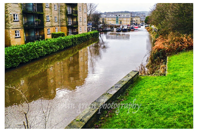
The images of the canal near Kirkham Turn and the Calder & Hebble Navigation show the water level rising to meet the surrounding land, turning the waterway into a vast, muddy lake. Houseboats, usually resting serenely, are caught in the swirling currents, their moorings tested by the floodwaters.


A Community's Resilience

While these pictures document the physical devastation, they also implicitly tell a story of resilience. The 2015 floods were the worst to hit the area since the 1960s, causing millions of pounds in property damage. Yet, from this shared hardship emerged an incredible community spirit. Neighbours helped neighbours, businesses were rebuilt, and the community came together to clean up the aftermath.

These photographs are more than just records of a flood; they are a testament to the power of nature and the enduring strength of the people who call the Calder Valley home. They remind us to respect our environment and to remember the challenges we have faced and overcome together.

The flooded Calder & Hebble Navigation and Rochdale Canals from Chain Bridge.

The Calder & Hebble overflowing at Chain Bridge.

Rochdale Canal from Tower Hill Bridge. The towpath can normally be seen to the
right of the canal, the small wall probably prevented the car park and nearby town
centre from further damage.

Tuel Lane Lock gates flowing over.

The River Calder flowing past Kingfisher Chase towards Lockhart Mills. The levels is
normally 15 - 20ft lower than this.

The flooded Kirkham Turn. This is where the Rochdale canal joins the Calder &
Hebble Navigation.

Flooding at Tuel Lane Lock on the Rochdale Canal.

Very High River Calder flowing past the Weaving Shed Apartments (right of picture) and
Dugdales Mill left of picture. Dugdales was severely flooded during this event.

River Calder at Gas Works Bridge, considering the damage done to Cromwell, Copley and
Elland Bridges, I was surprised that Gas Works Bridge still stood after the floods.

River Calder at Gas Works Bridge, looking more like a dam head than river crossing.

High level River Calder at Lockhill Mill, much of the red brick building was damaged beyond
repair by the flood and demolished the year after.

River Calder from above the Turks Head Beer Garden, the lower half of the iron footbridge
was just in to the flooded area. Dugdales mill storage yard can be seen heavily
flooded in the background.

Please take a moment to share this post, follow me on social media, and explore my work on Clickasnap and Photo4Me using the links below. Your support means a lot!


All the pictures remain the copyright of Colin Green.

Sowerby Bridge: A Canal-side Journey Back in Time

On a grey and atmospheric day back on January 25th, 2014, I took a stroll with my Samsung Galaxy tablet along the Sowerby Bridge Canal Wharf...