Sometimes, the most rewarding adventures are found right on our doorstep. On a crisp day in late March 2019, with my trusty Nikon D3300 in hand, I set out to explore the waterways that wind their way through Brighouse and its surroundings. The goal was simple: to capture the essence of the River Calder and the Calder & Hebble Navigation as they unfolded before me.
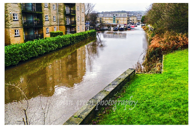
The journey began near the heart of Brighouse, where the River Calder meets the navigation at the Calder & Hebble Junction. The water here seemed to hold a mirror to the world, reflecting the bare branches of the trees and the sturdy, red-brick buildings that line the banks. It’s a place where industrial heritage and natural beauty coexist—a reminder of the area’s rich history.
Moving away from the town, the landscape began to shift. The path became a quiet haven, a tranquil corridor flanked by trees, their reflections dancing on the surface of the water. At a spot near Cromwell Bottom, the setting sun cast a golden glow, creating a beautiful interplay of light and shadow. The whole scene felt peaceful and timeless, a perfect escape from the hustle and bustle of everyday life.
Further on, the walk brought me to some of the engineering marvels of the navigation. The Calder & Hebble Navigation under the M62 motorway is a study in contrasts. The colossal concrete pillars supporting the roaring traffic above loom large over the calm water below. It’s a powerful juxtaposition of modern infrastructure and the historical, slow-paced world of the canal.
At Brookfoot, the path became even more secluded, with lush greenery and overhanging trees creating a natural archway. I spotted a small waterfall cascading gently, adding to the soothing sounds of the water. This spot, at the Brookfoot Lock, felt particularly serene. The lock itself, with its black and white gates and the stone lock house, felt like a scene from another era, a testament to the hard work and ingenuity that shaped this landscape.
My journey on this day was a reminder of the simple joys of observation. Armed with my camera, I wasn't just walking; I was seeing. I saw the sun glinting off the river in Brighouse, the subtle play of light and shadow, the powerful presence of the M62, and the peaceful stillness of the canal. Each photograph tells a small part of the story of these waterways, and together, they paint a picture of a landscape that is both beautiful and full of history.
It's amazing what you can discover when you take the time to look closely. I hope these images inspire you to take your own walk along a local path and see what stories you can find.
The pictures below are displayed in no particular order from the walk, clicking any of them should open a link in another window to my Colin Green Photography store on Zazzle.
 |
| The Calder & Hebble Navigation towards Ganny Foot Lock |
 |
| The Calder & Hebble Navigation at Brookfoot bend. |
 |
| Brookfoot Lock on the Calder & Hebble Navigation. |
 |
| The M62 Motorway over the Calder & Hebble Navigation at Brighouse. |
 |
| Calder & Hebble at Cromwell Bottom. |
 |
| The junction of the Calder & Hebble Navigation and River Calder at Brighouse. |
 |
| The River Calder at Brighouse. |
Please take a moment to share this post, follow me on social media, and explore my work on Clickasnap and Photo4Me using the links below. Your support means a lot!


All the pictures remain the copyright of Colin Green.