In an age of bustling, modern transport hubs, there's a unique and quiet beauty to a place like Castleton Moor Railway Station. Tucked away on the scenic Esk Valley Line, this stop in North Yorkshire feels like a step back in time. It’s a place where the journey is as much about the destination as the space in between.
Castleton Moor, which connects Middlesbrough with the coastal town of Whitby, has a history that stretches back over 160 years. Opened on April 1, 1861, as simply "Castleton," the station was once a much busier place. Originally, it was a two-platform station with a passing loop, complete with a signal box and a goods warehouse. But like many small stations across the UK, its facilities were streamlined over the years, with these features being removed in the early 1980s. The station was renamed Castleton Moor in March 1965, a subtle change that reflects its quiet, moorland surroundings.
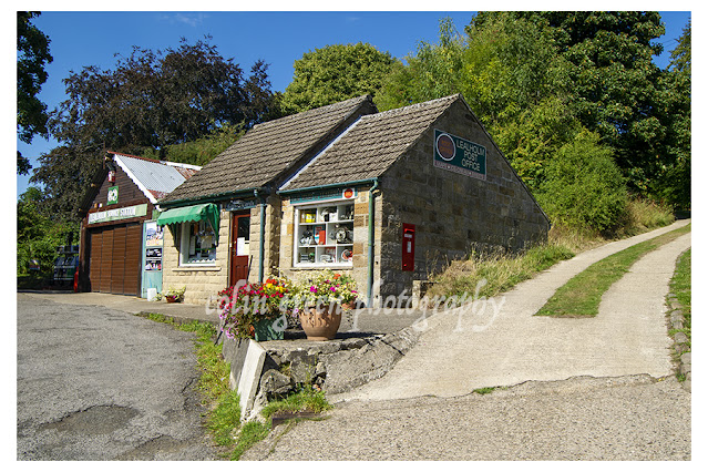
Today, the station retains a charming simplicity. Its main building, a handsome stone structure with classic Victorian railway architecture, is no longer a ticket office or waiting room. It has been beautifully converted into a private residence, watched over by a row of traditional chimney pots. This transformation adds to the station's unique character, creating a sense of a living, breathing history.
For the traveler, the station offers a peaceful waiting experience. A basic shelter, information boards, and a ticket machine are all that's needed here. This low-key functionality is a far cry from the crowded stations of major cities and is a key part of its appeal.
The numbers tell a story of a station serving its local community. With 4,732 passengers in the last full year of recorded stats, the station sees an average of around 91 people a week. It's a modest but vital link for the village, with 11 trains per day—five heading towards the dramatic coast at Whitby and six making the journey towards Middlesbrough.
These photos, taken on a sunny day in August 2022, capture the station's tranquillity perfectly. The bright blue sky, the meticulously maintained buildings, and the lush greenery and wildflowers growing along the tracks all contribute to its picturesque charm. Castleton Moor Railway Station is a beautiful reminder that sometimes, the most interesting stories are found not in grand, sweeping gestures, but in the quiet, enduring places that connect us to the past.


Clicking any picture should open a link in another window to my Colin Green Photography store on Zazzle.
Please take a moment to share this post, follow me on social media, and explore my work on Clickasnap and Photo4Me using the links below. Your support means a lot!


All the pictures remain the copyright of Colin Green.