Showing posts with label Sketch. Show all posts

Monday, 29 August 2022

A Snapshot of Village Life: Lealholm Post Office & Service Station

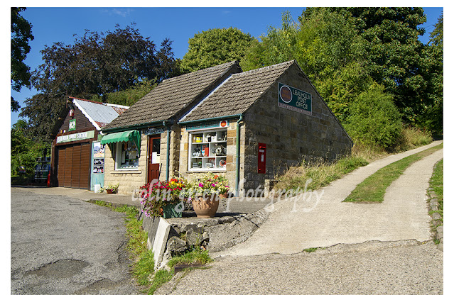
Lealholm is a village that seems to exist at its own pace, a peaceful hamlet nestled in the heart of the Esk Valley. On a sunny day in August 2022, I found myself exploring this tranquil corner of North Yorkshire, having just visited the quaint Lealholm Railway Station. As I walked back towards the village centre, I stumbled upon a truly charming sight: the Lealholm Post Office and Service Station.

What immediately caught my eye was how a seemingly ordinary stone house had been transformed into what is undoubtedly a central hub for the local community. It’s a place that feels as if it has grown organically from the landscape, serving the needs of the village's approximately 380 residents and the surrounding rural communities.

The photographs, taken with my Nikon D3300 SLR camera, capture the essence of this little building. There's a certain timeless quality to it. The stone exterior, the traditional roof tiles, and the potted flowers by the front door all contribute to a sense of warmth and welcome. The vibrant red of the post box stands out against the muted tones of the stone, a small but powerful symbol of connection.

This place isn't just a post office; it's a vital service station as well, a testament to its role in a rural area where such amenities are a lifeline. In a world of digital communication and big-box stores, there's something incredibly reassuring about seeing a place that combines these essential services under one roof. It speaks to a way of life that values convenience and community in equal measure.

The art-style versions of the photograph, with their textured, painterly effect, add another layer of charm. They transform the scene into something more than just a snapshot; they make it feel like a cherished memory or a piece of folk art. They highlight the rustic, lived-in quality of the building and the lush, green backdrop of the surrounding hills.

This image, and the feeling it evokes, reminds me of the unique character of rural life. It’s a world where a single building can be a post office, a shop, and a place to fill up your car, all at once. It’s a place where neighbours likely know each other by name and where a trip to the post office is not just an errand but a chance for a chat. The Lealholm Post Office and Service Station is more than just a building; it’s a heartbeat of the community, a humble yet essential hub of village life.

Clicking the images below should open a link in another window to my Colin Green Photography store on Zazzle.


Please take a moment to share this post, follow me on social media, and explore my work on Clickasnap and Photo4Me using the links below. Your support means a lot!


All the images remain the copyright of Colin Green.

Saturday, 23 July 2022

Bridging the Gap: A Photographer's Journey

As a photographer, I've always been drawn to bridges. They're more than just structures connecting two points; they’re symbols of human ingenuity, history, and a connection to the world around us. Recently, I've been exploring different ways to capture these marvels, playing with filters and post-processing to create a painterly, almost dreamlike effect. The result is a series of images that feel both real and fantastical, blurring the lines between photography and art.

In this collection, I've focused on some of the UK's most iconic bridges. Each one has its own story and a unique aesthetic.

Connel Bridge, Oban, Scotland.


Nestled in the breath taking landscape of Western Scotland, the Connel Bridge is a remarkable feat of engineering with a storied past. Originally built as a railway crossing over the narrow mouth of Loch Etive, the bridge was officially opened in August 1903. Constructed at a cost of £43,000, it served the Ballachulish Branch Line of the Callander and Oban Railway, a vital link for the region's transport network.

For many years, the bridge was exclusively for rail traffic. However, in 1914, a new chapter began when a roadway was added, allowing both cars and trains to use the same crossing. This dual-purpose use was managed with a unique set of rules: trains were given priority, and the roadway was closed to vehicles whenever rail traffic was scheduled to pass. This continued until the railway line was closed in the late 1960s, at which point the bridge became solely for road use. Today, the A828 road still runs across the single-track bridge, with traffic lights managing the flow of cars and ensuring a smooth passage for all.


Engineering and the Falls of Lora

The design of the Connel Bridge is as fascinating as its history. It is a cantilever bridge, a style chosen specifically to withstand the unique natural forces of the area. The bridge's impressive 524-foot span was a necessary measure to clear the challenging waters below. Just to the west of the bridge are the Falls of Lora, a series of tidal rapids created by the strong flow of water in and out of Loch Etive. These powerful currents were a significant consideration for the original engineers, who designed the bridge's structure to handle the immense pressures and prevent any obstructions in the water below.

Rising to a height with a 14-foot restriction, the bridge is perfectly positioned to offer a stunning view of the surrounding scenery. Just to the north, you can see the nearby Oban Airport, a modern landmark in an area rich with historical and natural wonders.

The Forth Bridge


Opened in 1890, the Forth Bridge is more than just a crossing; it's a defining symbol of Scotland's industrial might and a globally recognized feat of engineering. Located just east of Edinburgh, this monumental structure spans the Firth of Forth, connecting the communities of North and South Queensferry. While it's commonly known as the Forth Rail Bridge, its official name is simply the Forth Bridge, as it was the first of the three crossings to be built here.

The bridge's history is as impressive as its scale. Designed by the visionary engineers Sir John Fowler and Sir Benjamin Baker, construction began in 1882. At the peak of its construction, the project was a massive undertaking, employing a workforce of over 4,600 men. Their collective efforts culminated in the bridge's completion in December 1889. Following extensive testing, the bridge was officially opened on March 4, 1890, by the Duke of Rothesay, who marked the occasion by driving in the final gold-plated rivet.


Design, Scale, and Legacy

The Forth Bridge's distinctive cantilever design was a revolutionary choice for its time, built to handle the immense forces of a railway crossing. The bridge has a total length of 8,094 feet, with a maximum width of 120 feet at its piers. It soars to a height of 316 feet, providing a staggering 150 feet of clearance for ships to pass safely beneath at high tide.

In recognition of its historical and architectural significance, the Forth Bridge was designated a UNESCO World Heritage Site. It remains one of the most famous man-made structures in Scotland, a powerful testament to the ingenuity and sheer hard work of the men who built it.

Albert Bridge, Belfast, Northern Ireland

Spanning the River Lagan in the heart of Belfast, the Albert Bridge is a testament to the city's resilience and a graceful example of 19th-century engineering. Completed in 1890, this elegant structure was designed by the esteemed J.C. Bretland to replace a previous bridge that had tragically collapsed in 1886. This earlier failure underscored the need for a robust and reliable new crossing, and Bretland's design delivered on that promise.

Constructed at a cost of £36,500—an astronomical sum at the time, equivalent to approximately £5.2 million in today's currency—the bridge was a significant investment in the city's infrastructure. Its name honors Prince Albert Victor, the grandson of Queen Victoria, connecting the bridge to the rich history of the British monarchy.

With its striking architectural features and a vital role in connecting the city, the Albert Bridge is more than just a crossing; it's a piece of Belfast's history, a silent witness to the city's transformation over more than a century.

Clicking any of the images should open a link in another window to my Colin Green Photography store on Zazzle.

Please take a moment to share this post, follow me on social media, and explore my work on Clickasnap and Photo4Me using the links below. Your support means a lot!


All the images remain the copyright of Colin Green.

Saturday, 18 June 2022

Step Back in Time in Saltburn-by-the-Sea

There's something magical about a town that feels suspended in time, and Saltburn-by-the-Sea is one of them. Nestled on the North Yorkshire coast, this Victorian-era gem offers a nostalgic escape from the modern world, inviting you to wander through its history. Looking at these images, you can almost feel the sea spray and hear the echoes of generations of visitors enjoying the coast.


The Pier and Promenade

The heart of Saltburn's coastal charm is its magnificent pier. Stretching out into the North Sea, it's a testament to Victorian engineering and a perfect place for a leisurely stroll. The old photos show it as a lively hub, with people dressed in period clothing enjoying the fresh sea air. This sense of timeless enjoyment remains today. The long wooden walkway, with its sturdy iron railings, feels like a bridge connecting the past and the present. It’s a wonderful place to watch the waves crash or simply take in the vast horizon.

The promenade below the pier is just as captivating. In these photos, you can see people gathering, strolling, and enjoying the lively atmosphere with the pier buildings and cliffs as a dramatic backdrop. It's a reminder of a bygone era when seaside towns were the ultimate destination for leisure.


The Saltburn Tramway

One of the most unique features of Saltburn is its Cliff Tramway. This funicular railway, seen in several of the images, is a marvel in itself. It was built to transport visitors from the town's elegant clifftop gardens down to the promenade and pier below. The tramway's charming little cabins look like they belong in a fairy tale, and its steep descent down the cliff face offers incredible views of the coast. It’s not just a ride; it’s an experience that tells the story of the town’s development as a Victorian resort.

A Tale of Two Cliffs

The pictures also beautifully capture the stunning geology of the area. On one side, you have the dramatic, crumbling slopes that the tramway descends, with the grand Zetland Hotel perched at the top like a crown. On the other, the imposing Hunt Cliff stands tall, its sheer face a striking contrast to the gentle curves of the beach.

Below Hunt Cliff, you can see the cluster of buildings that make up the Ship Inn. With its long history as a smugglers' haunt, the inn and the surrounding cottages feel rugged and authentic, perfectly blending into the landscape of the bay.

Saltburn-by-the-Sea is more than just a place; it's a journey. From the bustling pier and the historic tramway to the dramatic cliffs and the quaint cottages, every corner has a story to tell. It’s a place to slow down, breathe in the salty air, and appreciate a slice of coastal history.


These artworks are based on very old postcards, clicking any of them should open a link in another window to my Colin Green Photography store on Zazzle.

Please take a moment to share this post, follow me on social media, and explore my work on Clickasnap and Photo4Me using the links below. Your support means a lot!


Sunday, 12 June 2022

Luddenden Village in Art Images

Luddenden's story is inextricably linked to the Luddenden Brook, which flows through its very heart. First referenced in 1274 in connection with a humble corn mill, the village's identity began to shift over the following centuries. The rushing waters of the brook were harnessed to power a growing number of textile mills, transforming Luddenden from an agrarian settlement into a hub of industry. This history is etched into the very stones of the village, a constant reminder of its industrial past.

For centuries, Old Lane was the main artery connecting Luddenden to the wider world, a busy thoroughfare for travellers heading to and from Halifax. However, progress altered the village's trajectory. In the mid-18th century, a new turnpike road was built just half a mile to the south, diverting traffic and commerce. This new route led to the rise of Luddenden Foot, a separate village that grew up around the modern transportation link, leaving Luddenden to settle into a quieter, more residential existence.


Echoes of the Past, Lingering Stories

Walking through Luddenden is like stepping back in time, with each landmark holding a piece of a larger narrative. The War Memorial stands as a solemn tribute to the combined communities of Luddenden and Midgley, a poignant reminder of their shared sacrifices. The towering presence of St. Mary's Church has watched over the village for generations, a spiritual and architectural centrepiece.

Perhaps one of the most intriguing connections to a bygone era lies within the walls of the Lord Nelson Inn. This historic pub was a regular haunt of Bramwell Brontë, the talented, yet troubled, brother of the famed literary sisters. His time spent working on the nearby railway led him to find solace and company at the inn, a detail that adds a fascinating, human touch to the village's lore.

Tragically, like many small villages, Luddenden has seen changes that have diminished its commercial life. Since the 1980s, the small shops and businesses that once served as the village's communal hubs have closed, leaving behind a collection of houses. While the village remains a beautiful place to live, it is a living example of a community that has evolved from a bustling centre of industry and commerce into a quiet, residential enclave, its history preserved in its stone buildings and timeless landscapes.

The images below were originally photo's that I have added various photoshop filters to create artworks. Clicking anyone of them should open a link in another window to my Colin Green Photography store on Zazzle.


The pictures below feature in the video above.

Old Lane was once part of the main packhorse route towards
Halifax, the M62 motorway of it's day until replaced by the turnpike
in the mid 18th century.

St Mary's Church.

The Luddenden Brook, this once helped to power of a dozen mills
for the textiles and corn (Flour) industries.

In the basement of the former St Mary's School, there were 3 holding cells,
although one has long since been removed. The 2 remaining have the townships
of Midgley and Warley inscribed in the lintel. The nearby Luddenden Brook
was the boundary between the 2, the removed cell is said to have had
Luddenden inscribed above it, no evidence remains. The cells were built
along with the school in 1825 and are not thought to have held occupants
since the 19th century.

The steps disused since the late 80's early 90's once provided
access to the offices of a mill that once occupied the site. Much
of the mill was demolished and replaced by housing.

Luddenden Brook and High Street Bridge.

Luddenden & Midgley War Memorial, unviled 1923.

Lord Nelson Inn from the churchyard of St Mary's.

High Street, Luddenden, the building towards the bottom was
the offices for the steps pictured earlier.

Inside St Mary's Church.

Luddenden Brook.

A closed off stone doorway alongside Luddenden Brook.

A memorial wheel to represent the ones that the corn mill that
once occupied the valley would have used.

Former Water Horse Trough at the bottom of Stocks Lane.

This cobbled yard is actually a bridge over Luddenden Brook, providing
access from High Street to High Street Court.

Lord Nelson Inn.

St Mary's Church clock tower.

Luddenden brook flows over the weir viewed from the churchyard
of St Mary's.

Please take a moment to share this post, follow me on social media, and explore my work on Clickasnap and Photo4Me using the links below. Your support means a lot!


All the images remain the copyright of Colin Green.
Sunday, 29 May 2022

Griffin Park, Brentford.

Not a set of football pics but a set of art works created by me of the former Griffin Park Football Stadium, Home of Brentford Football Club until 2020. 

Griffin Park opened on the 1st September 1904 with a 1-1 draw between Brentford and Plymouth Argyle, and closed after the final game between Brentford "B" and Erith Town in the London Senior Cup. The record attendance for a Brentford FC match at the ground was 38678 fora FA Cup 6th round tie against Leicester City in the February 1949, Brentford lost 2-0.

The ground has featured athletics, tennis, Gaelic Football and baseball in the early part of it's history, and was the home ground of the London Broncos Rugby League team from 2002 until 2006.

Other notes of interest about Griffin Park is the stadium being underneath the flight path of Heathrow Airport and the roof of the stands being used as giant advertising boards, and a pub being situated on each corner of the ground.

Clicking the images below should open a link in another window to my Colin Green Photography store on Zazzle.


Please take a moment to share this post, follow me on social media, and explore my work on Clickasnap and Photo4Me using the links below. Your support means a lot!


All the pictures remain the copyright of Colin Green.

Friday, 6 May 2022

The Tees Transporter Bridge: An Icon at a Crossroads

The Tees Transporter Bridge, a colossal symbol of industrial heritage, holds the distinction of being the longest remaining transporter bridge in the world. Yet, this magnificent structure, a testament to early 20th-century engineering, currently faces an uncertain future, standing closed and in dire need of significant repairs.

Opened in October 1911 at an impressive cost exceeding £68,000, the bridge revolutionized crossings over the River Tees. It replaced a long-standing ferry service, providing a more efficient and reliable link between Middlesbrough and Port Clarence. The decision to build a transporter bridge, rather than a conventional one, was a stroke of genius. This design allowed large ships to navigate the Tees unhindered, preserving vital shipping routes to industries further upstream—a crucial consideration for the burgeoning industrial landscape of the era. Interestingly, when first constructed, the bridge sported a vibrant red hue, only to adopt its now-iconic blue livery in 1961.

The bridge's historical and engineering significance has been formally recognized on several occasions. It was granted Grade II listed status on June 21, 1985, acknowledging its architectural and historical importance. Further recognition came in December 1993 with a Heritage Plaque from the Institution of Mechanical Engineers, celebrating its ingenious design and construction.

Despite its storied past and undeniable significance, the Tees Transporter Bridge has been closed to the public since August 2019 due to safety concerns. Its continued closure casts a shadow over its future, raising questions about the extensive work required to bring it back to a safe and operational state. Will this grand dame of engineering be restored to its former glory, or will it remain a static monument to a bygone era? Only time will tell if this vital piece of the Tees Valley's identity will once again carry passengers and vehicles across the river it has faithfully served for over a century.


Clicking on either picture should open a link in another window to my Colin Green Photography store on Zazzle.

Please take a moment to share this post, follow me on social media, and explore my work on Clickasnap and Photo4Me using the links below. Your support means a lot!


All the pictures remain the copyright of Colin Green.

Saturday, 23 April 2022

Comic Book Style Artworks of Sowerby Bridge

         
My Sowerby Bridge in comic book style images was a set of pictures created by me, that are based on photographs I had taken earlier. I created the artworks as part of a YouTube video slideshow, mainly to try and show something different to my usual. All the images can be seen below the YouTube Video and each place is named although i'm sure if you are local to Sowerby Bridge you will know where they are.


The following images are all featured in the slideshow, clicking on any of them should open a link in another window to my Colin Green Photography store on Zazzle.

The Canal Basin, the picture shows the Calder & Hebble side with the Moorings
bar visible. The boats moored are those of Shire Cruises.

Bolton Brow Wesleyan Chapel, the building is now apartments.

The canal basin, the Calder & Hebble side featured again.

Church Bank from Sunnybank Street, Christ Church Clock Tower is visible.

Church Bank, Orrell House to the left

Hollins Mill Tunnel, The Rochdale Canal passing through it's arch.

The Jubilee Refreshment Rooms, formerly Sowerby Bridge Railway Station
ticket office.

Lock Number 2 on the Rochdale Canal, Christ Church Clock Tower, Ladstone
and Houghton Towers can be seen on the skyline.

This mileage sign can be found on the Rochdale Canal to the west
of Hollins Mill Tunnel.

The mainline railway viaduct crossers over the River Ryburn, just
before the Ryburn joins with the River Calder.

The River Calder at Mearclough Bridge, (Milner Royd).

The River Ryburn near the Swimming Baths towards Station Road.

Lock 2 on the Rochdale Canal, the Roxy is the building on the left.

Looking over the town from Beech Road.

Sowerby Bridge Railway Station.

The River Calder Canoe Slalom from County Bridge.

The Town Hall Clock Tower, formerly Lloyds Bank, soon to be a restaurant,
never been a town hall from County Bridge.

The Rochdale Canal in to Tuel Lane Tunnel, this section was reopened
in the late 1990's, Christ Church is in the centre and the Roxy to the right.

Victoria Bridge over the River Ryburn.

Village Indian Restaurant, formerly the Wharf and Ash Tree pubs.

Willow Hall Dam, the waterfall is the overflow from the upper dam
in to the lower dam featured.

Please take a moment to share this post, follow me on social media, and explore my work on Clickasnap and Photo4Me using the links below. Your support means a lot!


All the images remain the copyright of Colin Green.

Sowerby Bridge: A Canal-side Journey Back in Time

On a grey and atmospheric day back on January 25th, 2014, I took a stroll with my Samsung Galaxy tablet along the Sowerby Bridge Canal Wharf...