As a collector of postcards, I often find myself lost in the stories they silently tell – tales of travel, connection, and moments frozen in time. Today, I'm excited to share a couple of intriguing additions from my large collection, one of which presents a delightful little historical puzzle!
Take a look at this charming postcard:
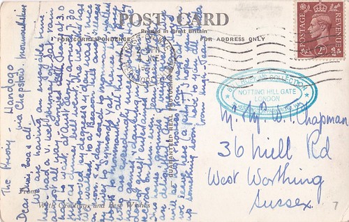
This particular card, featuring The Priory, Llandogo, Monmouthshire, Wales, carries a fascinating journey within its aged fibres. What immediately captivated me was the postmark: June 4th, 1954, from the picturesque town of Ross-on-Wye, Herefordshire. It was addressed to a "Chapman" at 36 Hill Road, West Worthing, Sussex – a lovely, tangible link to lives lived decades ago.
However, a closer inspection of the stamp has thrown a delightful spanner in the works! The stamp clearly depicts King George VI. For those familiar with British history, you'll know that King George VI sadly passed away in 1952.
This discrepancy immediately sparks a few questions:
Was the postcard truly posted in 1954? It's possible that a stamp from 1952 (or earlier) was still in use and valid for postage two years later. Royal Mail often allows for a period where old stamps remain valid after a new monarch accedes to the throne. This would be the most straightforward explanation.
Could the postmark be slightly misread or unclear? While I've checked it carefully, sometimes aged ink and paper can play tricks on the eyes.
Is there a less common scenario at play? Perhaps it was a special issue or a collector's item used unusually? (Though this is less likely for a standard postcard.)
This little puzzle only adds to the charm and historical value of the postcard for me. It's a tangible reminder that even seemingly simple artifacts can hold layers of history and intrigue. It also highlights the importance of scrutinizing every detail when exploring historical items!
The image itself, of The Priory in Llandogo, offers its own quiet beauty. Nestled in the heart of Monmouthshire, Llandogo is a village known for its stunning Wye Valley scenery. I can almost imagine the sender enjoying the tranquillity of the area before sending this snapshot across the country.
The postcard reads as best as I can as follows, if I can't make the word out I will just underscore
The Priory - Llandogo
Via Chepstow, Herefordshire.
Dear Denis, Eva and All,
We are having an enjoyable time here, had a v. wet journey on Saturday. Rain almost all the way. Arrived without Jerry at 3.00, had to wait at ____Jerry arrived 7.30 just as the dinner bell went the weather has been _______ __ ______ __ day was nice we walked to a beacon hill and villages ___ most of the rest of the card I unable to make out but it ends with, I hope you fix something up soon, love to you all ______Love from Hugh and Jerry.
The 2nd postcard I want to feature is of Happy Valley, Llandudno, these are a set of gardens that are home to wildlife animals and plants and still popular today. Llandudno Pier can also be seen in the picture.
Please take a moment to share this post, follow me on social media, and explore my work on Photo4Me and Clickasnap using the links below.
There’s something truly magical about holding a piece of history in your hands, especially when it’s a vintage postcard. Each one tells a story, not just of the place it depicts, but of a moment in time, a connection between people, and a glimpse into a bygone era.
Part of my own collection is this charming postcard, offering a serene view across Happy Valley Gardens in Llandudno, with the elegant town pier stretching out into the distance.
Frozen in Time: August 11th, 1950
What makes this card particularly special is its postmark: August 11th, 1950. Imagine the scene on that summer's day. Was it a family holiday, a romantic getaway, or a peaceful escape to the Welsh coast? The card itself doesn't tell us who sent it or to whom, but it invites us to ponder the lives connected by this small piece of cardstock.
In 1950, Britain was still recovering from the war years, but tourism was steadily re-emerging. Llandudno, with its grand Victorian architecture and stunning natural beauty, was already a popular destination. Picture the visitors strolling through Happy Valley, enjoying the vibrant flower beds, perhaps riding the cable car or the Great Orme Tramway, and then heading towards the pier for a leisurely walk, an ice cream, or even a paddle in the Irish Sea.
The Enduring Charm of Happy Valley and Llandudno Pier
Looking at the postcard, it's striking how much, and yet how little, has changed. Happy Valley Gardens remains a beautiful, tranquil oasis, nestled on the slopes of the Great Orme. It's still a place where you can find peace, enjoy panoramic views, and escape the hustle and bustle.
And the Llandudno Pier? It's as iconic today as it was 74 years ago. A magnificent example of Victorian engineering, it continues to be a focal point of the town, bustling with arcade games, kiosks, and people simply enjoying the sea air.
This postcard isn't just a picture; it's a window. It reminds us of the timeless appeal of Llandudno, a place that has welcomed visitors for generations. It also serves as a beautiful testament to the simple act of sharing a moment, a memory, and a view with someone far away.
Clicking the images below should open a link in another window to my Colin Green Photography store on Zazzle.
Posted to a Mr & Mrs R. Acton
34 Worsley Road
Lower Walton
Warrington
Lancs.
The text as best I can make reads as follows,
Llandudno, Thurs
Having a very enjoyable holiday and regret it is nearly over. Weather has been mixed, but we have not been forced indoors. Had some lovely tours, and found N. Wales as beautiful as ever.
Love Helga & Harry
Please take a moment to share this post, follow me on social media, and explore my work on Photo4Me and Clickasnap using the links below.
Perched atop the Redesdale Valley at a bracing 1371 feet above sea level, Carter Bar isn't just a point on a map; it's a dramatic threshold where England and Scotland embrace, a place steeped in history and blessed with breath taking vistas. If you've ever travelled the A68, approximately 58 miles southeast of Edinburgh or 45 miles northwest of Newcastle, you've likely encountered this iconic crossing, with the charming town of Jedburgh as its nearest neighbour.
A View to Remember, Whatever the Weather
Carter Bar is a magnet for passers-by, and it's easy to see why. The dedicated viewing area is almost perpetually dotted with visitors, cameras in hand, eager to capture the stunning landscapes that unfold before them. From this elevated vantage point, your gaze can sweep across the majestic Cheviot Hills, delve into the rolling expanses of the Scottish Borders, and stretch far into the untamed beauty of Northumberland.
But be warned: while the views are consistently spectacular, the weather can be a fickle companion. Such is the nature of an exposed, high-altitude crossing. Even on a summer's day, a chill wind can cut through, a stark reminder of its elevation. And don't be surprised to find lingering patches of snow well into late spring or even an early dusting in autumn – nature here plays by its own rules.
Stones of History: Marking the Divide
The precise line of the historic border between England and Scotland is unmistakably marked by two large, unassuming stones. These silent sentinels bear witness to centuries of ebb and flow between two proud nations, reminding us that while the landscape is continuous, a significant historical and cultural divide lies beneath our feet.
Echoes of Conflict: The Raid of Redeswire
Yet, Carter Bar is more than just a scenic viewpoint. It's a place where history resonates deeply. On a fateful day, July 7th, 1575, this very ground was the scene of the last major skirmish between the Kingdoms of England and Scotland – an event immortalized as the Raid of Redeswire. Imagine the clash of steel, the cries of battle, and the tension that must have hung heavy in the air as these two formidable nations vied for supremacy.
The Peacekeepers of the Marches: Truce Days
Before the unification of the crowns, the border regions were often volatile, prone to disputes and lawlessness. To maintain some semblance of order, a fascinating system of international law known as Truce Days, or March Law, was established. Carter Bar was a known venue for these gatherings. Here, cross-border grievances were heard and settled, overseen by the powerful Lord Warden of the Marches, individuals entrusted with the immense responsibility for the security of these borderlands.
These unique legal proceedings became obsolete after 1603, a pivotal year that saw King James VI of Scotland ascend to the English throne as King James I. The Union of the Crowns brought an end to centuries of often-fraught relations, rendering the need for March Law and its Truce Days unnecessary. The border, while still culturally distinct, was no longer a realm of frequent conflict and dispute.
A Moment Frozen in Time
Our own recent visit to Carter Bar on October 24th, 2018, captured with a trusty Nikon D3300 SLR camera, served as a powerful reminder of its enduring appeal. The crisp autumn air, the expansive skies, and the tangible sense of history made for a truly memorable experience.
So, the next time you find yourself traversing the A68, make sure to take a moment at Carter Bar. Step out, breathe in the fresh, often bracing, air, and let your gaze wander across the magnificent panorama. But more than that, let your mind wander through the rich tapestry of history that has unfolded on this very spot. For at Carter Bar, you don't just cross a border; you step into a living, breathing testament to the intertwined histories of England and Scotland.
Clicking any of the images below should open a link in another window to my Colin Green Photography store on Zazzle.
Please take a moment to share this post, follow me on social media, and explore my work on Photo4Me and Clickasnap using the links below. Your support means a lot!
All the pictures and video remain the copyright of Colin Green.
Here's an enhanced version of your blog post about the Ribblehead Viaduct, designed to be more engaging and in-depth:
My Ribblehead Viaduct Collection: A Journey Through Time and Stone
For enthusiasts of historical engineering and breathtaking landscapes, the Ribblehead Viaduct stands as an enduring testament to human endeavor. My personal collection of 17 photographs, with one rare shot from August 1976 and the remainder captured in April 2015, aims to offer a unique visual journey through its impressive history and majestic presence. You can explore these images across various platforms, including my Flickr, YouTube, and Clickasnap channels.
Subscribe to my YouTube channel to see more videos like this.
The Monumental Ribblehead Viaduct: A Symphony in Stone
Also known as the Batty Moss Viaduct, this magnificent structure is more than just a bridge; it's a 24-arch marvel that gracefully carries the historic Settle to Carlisle railway line across the picturesque Ribble Valley in North Yorkshire, England. Its sheer scale is awe-inspiring: stretching 400 meters long and reaching a towering 32 meters at its highest point, it proudly holds the title of the longest single structure on the Settle to Carlisle line, making it arguably the most famous. Each of its 24 arches spans approximately 14 meters, supported by foundations that plunge 7.6 meters deep into the earth.
A Tale of Grit, Sacrifice, and Victorian Ambition
The construction of the Ribblehead Viaduct was a monumental undertaking, fraught with challenges and human cost. Work commenced in either 1869 or 1870 (sources vary slightly) and concluded in August 1875. The sheer scale of the project demanded an enormous workforce, peaking at approximately 2,300 men. These navvies, along with their families, lived in temporary, often harsh, settlements that sprang up around the viaduct site. These makeshift towns had evocative names like Batty Wife Hole, Sebastopol, and Belgravia, offering a glimpse into the tough conditions endured by those who built this colossal structure. Today, the area where these settlements once stood, at the base of the viaduct, is recognized as a scheduled ancient monument, a poignant reminder of the lives lived and lost here.
Tragically, the construction came at a steep price. Over 100 men perished during the viaduct's creation, succumbing to accidents, altercations, and even an outbreak of smallpox. Beyond the workforce, more than 100 women and children from their families also lost their lives in these arduous conditions. Their sacrifice is solemnly remembered at the nearby St. Leonard's Church in Chapel-le-Dale, where a plaque stands as a lasting memorial to those who paid the ultimate price for progress.
From Blueprint to Reality: The Evolution of a Landmark
The vision for a railway route through this challenging terrain originated with the Midland Railway in the early 1860s. Despite initial attempts to withdraw from the planned line—a proposal firmly rejected by Parliament in April 1869—work defiantly began in November 1869. By July 1870, the foundations were underway, with the first stone ceremoniously laid in October 1870.
Interestingly, the initial plan called for 18 arches. However, a significant design change in 1872 led to the decision to build 24 arches, a modification that ultimately enhanced the viaduct's stability and aesthetic appeal. Despite this alteration, construction pressed forward with remarkable speed, and by the end of 1874, the stonework was gloriously complete. The first goods train rumbled across the viaduct in August 1875, followed by the inaugural passenger train in May 1876, marking the official opening of this engineering marvel to the world.
A Near Miss: The Battle to Save Ribblehead
The story of the Ribblehead Viaduct almost had a different, more somber ending. In the early 1980s, British Rail proposed closing the line, arguing that the prohibitively high cost of repairing the viaduct and other structures along the route made continued operation uneconomical. This sparked a fierce and passionate campaign to save the line.
Between 1981 and 1984, over £100,000 was spent on essential repairs to the viaduct, a clear indication of its deteriorating state. By the mid-1980s, the track across the viaduct had been reduced to single status, with a restrictive 20 mph speed limit imposed for safety. However, the tide began to turn. In November 1988, the viaduct was rightly granted Grade II listed status, a testament to its historical and architectural significance. By this time, a powerful and dedicated campaign group had mobilized, fiercely fighting the closure threat. Their relentless efforts, coupled with a notable increase in passenger numbers, ultimately secured the line's future. By 1989, the Settle to Carlisle line, and with it the Ribblehead Viaduct, was saved from closure, paving the way for major repairs that continued until 1991, ensuring its survival for generations to come.
Capturing History: My Photographic Approach
The majority of the pictures in my collection were taken on April 4th, 2015, using a Polaroid is2132 bridge camera. These modern shots aim to capture the viaduct's majesty in contemporary light, while the single 1976 image offers a rare glimpse into its past. For those interested in acquiring copies, un-watermarked versions of these photographs are available for purchase on Clickasnap.
The Ribblehead Viaduct continues to be a magnet for visitors. The Ribblehead Railway Station, located approximately half a mile south, serves as a gateway to this historic site. The surrounding area is incredibly popular with walkers, drawn by the dramatic landscapes and the awe-inspiring presence of the viaduct. For those seeking respite and refreshment, the Station Inn offers accommodation, food, and drink, all in the shadow of this iconic structure.
Clicking any of the images below should open a link in another window to my Colin Green Photography store on Zazzle.
At no stage when taking these pictures did I ever enter within the fenced off areas of the track, and I would not recommend anyone else does either.
Please take a moment to share this post, follow me on social media, and explore my work on Photo4Me and Clickasnap using the links below. Your support means a lot!
All the pictures remain the copyright of Colin Green.
Perched majestically above the meandering River Lune in the charming Cumbrian town of Kirkby Lonsdale stands St. Mary the Virgin, the Parish Church whose very stones whisper tales of centuries past. Officially known by its graceful name, this Grade I listed Anglican place of worship isn't just a building; it's a living chronicle of architectural evolution, community spirit, and unwavering faith.
A Tapestry of Time: Architectural Evolution
The church we see today has graced its elevated site since the 12th century, with remarkable remnants of its original Norman architecture still evident, particularly in the impressive nave arcades. Imagine the skilled hands that first laid these stones, shaping a sacred space that has endured for over 800 years.
However, St. Mary's isn't a static monument to one era. Its history is a fascinating journey of adaptation and expansion, reflecting changing architectural styles and the growing needs of its congregation. In the 14th century, the church underwent a significant transformation. The north and south walls were extended outwards, broadening the nave and creating a more expansive interior. This medieval modification speaks to a period of prosperity and increased devotion in Kirkby Lonsdale.
The early 16th century brought further embellishments, adding a touch of late medieval grandeur. A new clerestory was introduced, raising the roofline and flooding the interior with more light. Pinnacles and battlements adorned the exterior, giving the church a more imposing and decorative profile, typical of the Perpendicular Gothic style.
Yet, as architectural tastes shifted, so did the church's appearance. The 19th century ushered in an era of significant restoration and remodelling. In 1807, a new roof was added, and interestingly, the clerestory, pinnacles, and battlements from the 16th century were removed, perhaps deemed unfashionable or structurally unsound at the time.
The most extensive transformation, however, occurred in 1866 under the renowned architect E.G. Paley. Paley's work was comprehensive; he once again raised the roof, creating a more lofty and inspiring space. He re-floored the chancel, enhancing the area around the altar, and added a south porch, providing a grander and more welcoming entrance. These Victorian-era changes reflect the High Church movement's influence and a desire for more elaborate and reverent worship spaces.
Echoes of History in the Churchyard
Beyond the magnificent church building, the grounds of St. Mary's hold their own historical treasures. A number of Grade II listed monuments dot the churchyard, each telling a personal story of lives lived and remembered in Kirkby Lonsdale. These gravestones, with their weathered inscriptions, offer a poignant connection to generations past.
One particularly intriguing feature within the church grounds is a two-storey octagonal stone gazebo. Thought to date from the late 18th century, this charming structure adds a unique architectural flourish. Interestingly, it wasn't originally built on this spot; it was moved to its current location to the north of St. Mary's from the garden of the vicarage. This relocation speaks to a deliberate effort to preserve and integrate local historical elements into the church's wider precinct. Perhaps it served as a quiet retreat for contemplation for the vicar, or a picturesque folly in a grand garden, now offering a glimpse into the leisure and design sensibilities of a bygone era.
A Glimpse from 2015
The accompanying photographs, captured on April 4th, 2015, with a Polaroid is2132 camera, offer a specific snapshot in time of this remarkable church. While the images themselves may be from a particular moment, the essence of St. Mary the Virgin – its enduring beauty, rich history, and spiritual significance – remains timeless. Clicking any of the images should open a link in another window to my Colin Green Photography store on Zazzle.
Please take a moment to share this post, follow me on social media, and explore my work on Photo4Me and Clickasnap using the links below. Your support means a lot!
All the pictures remain the copyright of Colin Green.
Nestled approximately six miles north of Halifax, along the historic route to Haworth, lies the captivating expanse of Warley Moor. This isn't just any stretch of open land; it's a place where the wild beauty of the Pennines truly comes alive, offering a unique blend of stunning vistas, historical echoes, and a climate all its own.
Perched around 1,440 feet above sea level, just above the quaint village of Wainstalls in the area affectionately known as Top Withins, Warley Moor possesses a character as untamed as the winds that sweep across it. I've often set out from my home in the valley, perhaps Sowerby Bridge, under clear, calm skies, only to arrive at Warley Moor to be greeted by a dramatic shift – rain lashing down and a storm brewing. This meteorological capriciousness is one of the moor's defining features, giving it an almost mythical quality.
Locally, this enigmatic landscape is known by several names, each hinting at a different facet of its identity: Fly Flatts, conjuring images of open, windswept spaces; Top Withins, grounding it in its geographical context; and Ovenden Moor, reflecting its broader topographical connections.
Beyond its ever-changing weather patterns, Warley Moor offers truly unbeatable views. From its elevated position, your gaze can sweep across the intricate tapestry of the Calder, Hebble, and Oxenhope Valleys, a breath taking panorama that stretches to the horizon, revealing the rugged beauty of the West Yorkshire landscape.
Adding to the moor's distinctive character are two prominent landmarks. The tranquil waters of Warley Moor Reservoir lie cradled within the landscape, a serene counterpoint to the wild expansiveness of the moor. And standing as a testament to modern ingenuity, the towering turbines of Ovenden Moor Windfarm punctuate the skyline, a contemporary addition to a landscape steeped in history.
These photographs, captured on a Samsung Galaxy Tablet on October 5th, 2013, offer just a glimpse into the raw, untamed beauty of Warley Moor. They hint at a place where nature reigns supreme, where every visit offers a new experience, and where the line between land and sky often blurs into a captivating embrace
Clicking any of the images below should open a link in another window to my Colin Green Photography store on Zazzle.
Warley Moor Reservoir
Nestled within the dramatic embrace of Warley Moor, the serene expanse of Warley Moor Reservoir, affectionately known as Fly Flatts, stands as a testament to Victorian ambition and engineering prowess. This isn't merely a body of water; it's a vital piece of infrastructure, a hub of leisure, and a captivating landmark in its own right.
Its construction, a monumental undertaking, spanned a formidable eight years, finally reaching completion in 1872. This colossal project was spearheaded by the Halifax Waterworks Extension Scheme, a crucial initiative to quench the growing thirst of Halifax's burgeoning population during the industrial revolution. Imagine the sheer dedication and grit required by the navvies and engineers who toiled on this exposed moorland, transforming the landscape to serve a critical need.
When brimming to its capacity, Warley Moor Reservoir transforms into an impressive inland sea, covering a vast 68 acres. At its deepest point, the water plunges to 45 feet, holding an astonishing approximately 193 million gallons. This colossal volume underscores the scale of the Victorian vision to secure a reliable water supply for the expanding urban centres down in the valleys.
Today, this vital asset is meticulously owned and maintained by Yorkshire Water, ensuring its continued function as a key component of the region's water infrastructure. However, the reservoir's story extends beyond its utilitarian purpose. Since 1959, its waters have been the proud home of the Halifax Sailing Club. This is no ordinary sailing club; thanks to the reservoir's impressive elevation, it boasts the unique distinction of being the highest sailing club in Britain.
Imagine the exhilaration of harnessing the strong, unpredictable winds that sweep across Warley Moor, with panoramic views stretching out beneath you. The club's members not only enjoy the thrill of sailing in such a dramatic and elevated environment but also contribute to the vibrant community that thrives around this magnificent Victorian legacy. Warley Moor Reservoir, therefore, is not just a body of water, but a living piece of history, a crucial resource, and a beacon for those who seek adventure on the highest waters of Britain.
Ovenden Moor Wind Farm
The story of Ovenden Moor Wind Farm is a fascinating microcosm of the evolving landscape of renewable energy in the UK, particularly when set against the dramatic backdrop of the Pennine moors.
Opened in 1993, the original Ovenden Moor Wind Farm was a pioneering project, representing a significant investment of £12 million (equivalent to approximately €9.1 million with a €2 million contribution from the EU's Thermie Programme). At its completion, the site hosted 23 Vestas WD34 400 kW turbines, each standing 32 metres high with a 34.8-metre rotor diameter, combining to generate a total capacity of 9.2 MW. These early turbines were projected to have a lifespan of around 25 years and were designed to power approximately 5,500 homes.
However, the wind farm's presence was not without its controversy. Situated in an area of exceptional natural beauty, directly overlooking the globally renowned Brontë Country and the picturesque Calder and Hebble Valleys, the sight of these towering structures sparked considerable debate. Local communities and heritage groups, including the Brontë Society, voiced concerns about the visual impact on the cherished landscape and the potential disruption to the very essence of this historic literary setting. This tension between the need for renewable energy and the preservation of natural and cultural heritage remains a recurring theme in the development of onshore wind farms.
Fast forward to 2015, and the original turbines had served their purpose. In a move reflecting the rapid advancements in wind turbine technology, they were decommissioned. What followed was a significant repowering project, replacing the 23 older, smaller turbines with just 9 new, more powerful Gamesa G80-2MW units. These modern giants stand significantly taller, with a hub height of 75m and a tip height of 115m, and are capable of generating 2.5 MW each, for a total installed capacity of 22.5 MW. This dramatic reduction in the number of turbines, coupled with a substantial increase in individual turbine capacity, meant a far more efficient use of the site. The result? The repowered Ovenden Moor Wind Farm can now generate enough clean electricity to power an estimated 11,000 homes, effectively doubling its original output with fewer, but more impactful, structures.
The evolution of Ovenden Moor Wind Farm from its pioneering origins to its modern, repowered state exemplifies the ongoing journey of renewable energy. It highlights the technological leaps that have made wind power increasingly efficient, while also underscoring the enduring challenge of balancing energy needs with environmental and aesthetic considerations in cherished landscapes.
The video below shows a number of pictures taken around the moor on a number of visits including this one on the 5ht October 2013.
Please take a moment to share this post, follow me on social media, and explore my work on Photo4Me and Clickasnap using the links below. Your support means a lot!
All the pictures remain the copyright of Colin Green.