Showing posts with label Viaduct. Show all posts

Wednesday, 3 September 2025

A Journey Through Time: Mytholmroyd Railway Station

 On the last day of 2018, with my Nikon D3300 in hand, I took a stroll around Mytholmroyd, a village nestled in the heart of the Calder Valley. My destination was the railway station, a place that, like many others in this industrial landscape, holds a wealth of history and a quiet dignity. The photos I captured on that day tell a story of a place in transition—a past of industrial grandeur giving way to a new future.

The Old Station Building: A Glimpse into the Past

The most striking feature of the station is the original building. This Grade II listed building, with its rugged sandstone and classical lines, stands as a testament to the Victorian era of railway expansion. Opened in 1871 by the Lancashire and Yorkshire Railway, it was once the bustling hub of the community, complete with a booking hall, stationmaster's house, and waiting rooms. For many years, however, it sat derelict and boarded up, a sad sight for a building of such importance.

What the photos don't fully capture is the incredible story of its revival. After decades of neglect, a dedicated group of local volunteers, the Mytholmroyd Station Partnership, began a long-running project to bring it back to life. Their work, supported by grants from organizations like the Railway Heritage Trust and Northern, aims to transform the building into a creative community hub, breathing new purpose into this historic landmark.


The Viaduct and the Modern Station

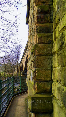
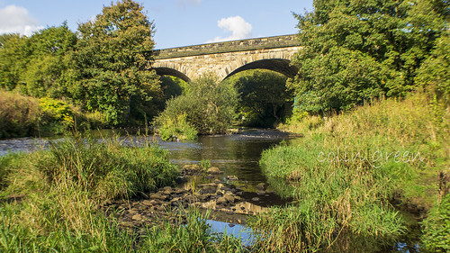
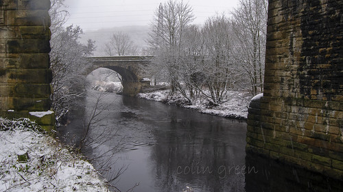
The station is uniquely situated atop a magnificent viaduct, a feat of 19th-century engineering. The viaduct itself was built by George Stephenson and dates back to 1840, making it even older than the station building it now supports. From the street below, the imposing stone arches give a sense of the scale and ambition of the railway age.

While the old building was awaiting its new lease on life, the modern station was already serving the community. With two platforms, it's a vital part of the Calder Valley Line, connecting the village to major cities like Leeds and Manchester. The station is known for having step-free access to its platforms, a rare and helpful feature for a station built on a viaduct. The contrast between the old, unused entrance and the bustling modern platforms tells the story of a place that, despite its challenges, remains a crucial link for the people of Mytholmroyd.

Clicking any of the images below should open a link in another window to my Colin Green Photography store on Zazzle.


Please take a moment to share this post, follow me on social media, and explore my work on Clickasnap and Photo4Me using the links below. Your support means a lot!


All the pictures remain the copyright of Colin Green.

Sunday, 3 August 2025

Bridging the Past and Present: Wiston Lane Railway Viaduct, Elland

 Nestled within the green embrace of Elland, West Yorkshire, lies a remarkable structure that quietly tells a tale of industrial ambition and enduring engineering: the Wiston Lane Railway Viaduct. As you approach it, whether on foot or by bicycle along the path that winds underneath, you can't help but be struck by its imposing yet elegant presence.

The viaduct, a stunning example of Victorian railway architecture, is constructed from local stone, its multiple arches gracefully spanning the landscape. Looking at its sturdy construction, it's easy to imagine the sheer effort and skill that went into its creation. While an exact construction date isn't immediately evident on site, the line was opened through this section in 1840.

This was a time when the "Iron Horse" was rapidly transforming the country, connecting towns and cities, and facilitating the movement of goods and people on an unprecedented scale. The Wiston Lane Viaduct was a crucial link in this network, forming part of the line that would have served the bustling industrial heartland of Yorkshire. You can almost hear the rumble of steam trains and the clang of goods wagons as they once traversed these very arches, carrying coal from the mines, textiles from the mills, and passengers on their journeys.

One of the most striking features of this location is the juxtaposition of old and new. As some of the images show, the railway viaduct stands proudly alongside the more modern Elland Bypass Bridge, a testament to the ongoing evolution of infrastructure. From certain angles, you can see both bridges in harmony, each serving its purpose in different eras of transportation. This layering of history truly makes Wiston Lane a fascinating spot for contemplation.

Today, while the steam trains may be a memory, the viaduct remains very much active. Modern trains, often a blur of white and blue as seen in one of the photographs, continue to cross its venerable structure, a continuous thread connecting past and present. The path underneath, a tranquil route for walkers and cyclists, offers a unique perspective on the viaduct's scale and impressive design. Lush greenery frames the arches, and the gentle murmur of the nearby water adds to the serene atmosphere.

Whether you're a history enthusiast, an admirer of engineering, or simply seeking a peaceful stroll amidst a touch of local heritage, a visit to the Wiston Lane Railway Viaduct is highly recommended. It's a place where you can tangible feel the echoes of a bygone era, and appreciate the enduring legacy of those who built the foundations of our modern world.

I took these pictures on the 18th August 2018 with a Nikon d3300, clicking any of the images should open a link in another window to my Colin Green Photography store on Zazzle.


Please take a moment to share this post, follow me on social media, and explore my work on Clickasnap and Photo4Me using the links below. Your support means a lot!


All the pictures remain the copyright of Colin Green.

Saturday, 16 September 2023

The Whitacre Mill Viaduct

Nestled in the green landscape of Deighton, near Huddersfield, the Whitacre Mill Viaduct is a silent witness to a bygone era of railway expansion. This impressive, disused railway bridge stands as a testament to the ambitions of the London & North Western Railway and its plan to connect Huddersfield with the Barnsley coal mines via the Kirkburton Branch Line.


A Bridge with a Story

Construction on the viaduct began in March 1865. Despite a partial collapse in February 1866, the viaduct was completed in time for the line's opening in October 1867. Although the grand plan for the railway was never fully realized, the viaduct served a short section of the line until its final closure in December 1971. Today, it stands as a monument to its industrious past, crossing the Huddersfield Broad Canal, the River Colne, and the valley below.


A Path Less Traveled

While the viaduct is largely overgrown on one side, it offers a unique walking experience from the Deighton side. Although challenging to navigate, the path provides a sense of adventure and a connection to the area's history. There are plans by Kirklees Council to transform the viaduct into a greenway, much like the nearby Bradley Viaduct, which would open this piece of history to a wider audience. Until then, it remains a secluded and beautiful spot, waiting to be rediscovered.

The pictures below were taken on the 27th May 2023 with a Nikon d3300.

The viaduct crossing the Huddersfield Broad Canal.

The top of the viaduct is supposed to be blocked off, I took this from the access point that has been removed. You can get approx. 2/3 of the way across before the bushes become to thick to pass, walking along the top of the wall would have allowed me to get further but I'm not great with heights, so I thought better of that idea.

Huddersfield Broad Canal pictured from the viaduct, Longlands Lock number 4 is just visible at the top of the picture.

The Huddersfield Broad Canal from Whitacre Mill Viaduct. The picture was taken in the direction of Huddersfield.

The overgrown former track bed looking towards the fence off access. The hole in the fence can be seen to the right of the picture if you follow the wall to the trees.


Please take a moment to share this post, follow me on social media, and explore my work on Clickasnap and Photo4Me using the links below. Your support means a lot!'


All the pictures remain the copyright of Colin Green.

Monday, 2 May 2022

Copley Railway Viaduct: A Hidden Gem in the Calder Valley

Nestled discreetly between the Old Rishworthians Sports Ground and the picturesque North Dean Woods, the Copley Railway Viaduct (officially known as MVN2/160 or Copley Bottom Bridge) stands as a testament to the rich railway history of West Yorkshire. This impressive structure, carrying the railway over the River Calder, is a true hidden gem just east of Copley village.

A Glimpse into the Past

Opened way back in August 1840 by the Manchester and Leeds Railway, this bridge was once a vital artery for main railway traffic through the entire Calder Valley. Imagine the hustle and bustle of early trains rumbling across its arches! Its prominence shifted somewhat with the construction of nearby lines at Milner Royd and Greetland Junctions, which diverted rail traffic towards Halifax.

Despite its historical significance, the line over Copley Viaduct faced closure plans in the late 1970s, especially after the closure of Brighouse (1970) and Elland (1962) stations. However, it persevered! It continued to serve as a crucial diversionary route for passenger trains and remained active for freight-only traffic during this period.

The year 2000 marked a significant turning point with the reopening of Brighouse Station. This brought passenger trains regularly crossing the Copley Viaduct once more, reconnecting this historic bridge to modern-day rail travel.

Photography Hotspot and Safety First!

One of the fantastic aspects of the Copley Viaduct is the open nature of the North Dean side, offering superb opportunities for photography enthusiasts. If you're keen on capturing the majesty of passing trains, especially the often-seen steam trains, this is an excellent spot.

However, and this is a crucial point, always remember to prioritise safety when near railway tracks. If you're venturing out to photograph, make sure to keep a safe distance away from the tracks. Staying well within the tree line, is always a good idea. Your safety is paramount!

These images were captured on a crisp 25th February 2019 using a Nikon d3300 SLR, showcasing the bridge's enduring beauty against a bright sky.

So, next time you're looking for a little piece of local history, consider seeking out the Copley Railway Viaduct. It's a truly impressive structure with a fascinating past and a continuing role in the Calder Valley's railway network.

Clicking any of the images below should open a link in another window to my Colin Green Photography store on Zazzle.

The Copley side of the viaduct

Taken on the North Dean side of the bridge, looking in the
direction of Copley.

The bridge again taken from the North Dean side.

Taken from the far end of Old Rishworthians sports ground.

The top of the bridge, the open nature of the track at the bottom of North
Dean Woods allows great access for taking pictures of trains passing.
Please be aware of a safety when near the lines, this is level with the tree
line which i consider a safe distance from the track. although when
trains are approaching I stand much further back than this.

The River Calder flows underneath the bridge,

The River Calder, taken looking towards Copley from underneath
the viaduct.

Again in the direction of Copley but from the other side of the bridge.

Please take a moment to share this post, follow me on social media, and explore my work on Clickasnap and Photo4Me using the links below. Your support means a lot!


All the pictures remain the copyright of Colin Green.

Saturday, 4 July 2020

Copley's Gem: The Lesser-Known Viaduct with a Rich History

When you think of railway viaducts in Copley, West Yorkshire, your mind probably jumps to the impressive, sprawling 23-arch structure. But just a few meters south lies an older, equally fascinating piece of engineering that often gets overlooked: the Manchester & Leeds Copley Viaduct.

Opened in 1840, a full 12 years before its more famous counterpart, this 3-arch viaduct holds a significant place in railway history. It was built by none other than the legendary George Stephenson, a name synonymous with pioneering railway development. Its historical importance was officially recognized on July 19th, 1988, when it was granted Grade II listed status.

The line crossing this historic bridge served passengers until 1970, coinciding with the closure of Brighouse Station. While passenger services officially ceased on September 1st, 1986, the line continued to see use for goods transport and occasional diverted passenger services between 1970 and May 2000.

There were discussions in the 1980s about potentially single-tracking the line over the 23-arch viaduct and completely closing the 3-arch viaduct. While this might have created a fantastic walkway stretching from Milner Royd Junction to Greetland, Elland, and Brighouse, many, myself included, believe a railway line serves a far more valuable purpose.

The Manchester & Leeds Copley Viaduct stands as a testament to early railway innovation and the enduring legacy of engineers like George Stephenson. Next time you're in Copley, take a moment to appreciate this unsung hero of the railway world.

Clicking any of the images below should open a link in another window to my Colin Green Photography store on Zazzle.

Copley Railway Bridge

The following video features the images and can be seen here and on YouTube. Please take a moment to subscribe to my channel.


Summer and the Calder at Copley Railway Bridge

Copley Railway Bridge Through the Pillars

Copley Railway Bridge Arch

Please take a moment to share this post, follow me on social media, and explore my work on Photo4Me and Clickasnap using the links below. Your support means a lot!


All the pictures remain the copyright of Colin Green.

Sunday, 14 June 2020

My Ribblehead Viaduct Collection: A Journey Through Time and Stone

Here's an enhanced version of your blog post about the Ribblehead Viaduct, designed to be more engaging and in-depth:


My Ribblehead Viaduct Collection: A Journey Through Time and Stone

For enthusiasts of historical engineering and breathtaking landscapes, the Ribblehead Viaduct stands as an enduring testament to human endeavor. My personal collection of 17 photographs, with one rare shot from August 1976 and the remainder captured in April 2015, aims to offer a unique visual journey through its impressive history and majestic presence. You can explore these images across various platforms, including my Flickr, YouTube, and Clickasnap channels.

Subscribe to my YouTube channel to see more videos like this.

The Monumental Ribblehead Viaduct: A Symphony in Stone

Also known as the Batty Moss Viaduct, this magnificent structure is more than just a bridge; it's a 24-arch marvel that gracefully carries the historic Settle to Carlisle railway line across the picturesque Ribble Valley in North Yorkshire, England. Its sheer scale is awe-inspiring: stretching 400 meters long and reaching a towering 32 meters at its highest point, it proudly holds the title of the longest single structure on the Settle to Carlisle line, making it arguably the most famous. Each of its 24 arches spans approximately 14 meters, supported by foundations that plunge 7.6 meters deep into the earth.


A Tale of Grit, Sacrifice, and Victorian Ambition

The construction of the Ribblehead Viaduct was a monumental undertaking, fraught with challenges and human cost. Work commenced in either 1869 or 1870 (sources vary slightly) and concluded in August 1875. The sheer scale of the project demanded an enormous workforce, peaking at approximately 2,300 men. These navvies, along with their families, lived in temporary, often harsh, settlements that sprang up around the viaduct site. These makeshift towns had evocative names like Batty Wife Hole, Sebastopol, and Belgravia, offering a glimpse into the tough conditions endured by those who built this colossal structure. Today, the area where these settlements once stood, at the base of the viaduct, is recognized as a scheduled ancient monument, a poignant reminder of the lives lived and lost here.

Tragically, the construction came at a steep price. Over 100 men perished during the viaduct's creation, succumbing to accidents, altercations, and even an outbreak of smallpox. Beyond the workforce, more than 100 women and children from their families also lost their lives in these arduous conditions. Their sacrifice is solemnly remembered at the nearby St. Leonard's Church in Chapel-le-Dale, where a plaque stands as a lasting memorial to those who paid the ultimate price for progress.


From Blueprint to Reality: The Evolution of a Landmark

The vision for a railway route through this challenging terrain originated with the Midland Railway in the early 1860s. Despite initial attempts to withdraw from the planned line—a proposal firmly rejected by Parliament in April 1869—work defiantly began in November 1869. By July 1870, the foundations were underway, with the first stone ceremoniously laid in October 1870.

Interestingly, the initial plan called for 18 arches. However, a significant design change in 1872 led to the decision to build 24 arches, a modification that ultimately enhanced the viaduct's stability and aesthetic appeal. Despite this alteration, construction pressed forward with remarkable speed, and by the end of 1874, the stonework was gloriously complete. The first goods train rumbled across the viaduct in August 1875, followed by the inaugural passenger train in May 1876, marking the official opening of this engineering marvel to the world.


A Near Miss: The Battle to Save Ribblehead

The story of the Ribblehead Viaduct almost had a different, more somber ending. In the early 1980s, British Rail proposed closing the line, arguing that the prohibitively high cost of repairing the viaduct and other structures along the route made continued operation uneconomical. This sparked a fierce and passionate campaign to save the line.

Between 1981 and 1984, over £100,000 was spent on essential repairs to the viaduct, a clear indication of its deteriorating state. By the mid-1980s, the track across the viaduct had been reduced to single status, with a restrictive 20 mph speed limit imposed for safety. However, the tide began to turn. In November 1988, the viaduct was rightly granted Grade II listed status, a testament to its historical and architectural significance. By this time, a powerful and dedicated campaign group had mobilized, fiercely fighting the closure threat. Their relentless efforts, coupled with a notable increase in passenger numbers, ultimately secured the line's future. By 1989, the Settle to Carlisle line, and with it the Ribblehead Viaduct, was saved from closure, paving the way for major repairs that continued until 1991, ensuring its survival for generations to come.


Capturing History: My Photographic Approach

The majority of the pictures in my collection were taken on April 4th, 2015, using a Polaroid is2132 bridge camera. These modern shots aim to capture the viaduct's majesty in contemporary light, while the single 1976 image offers a rare glimpse into its past. For those interested in acquiring copies, un-watermarked versions of these photographs are available for purchase on Clickasnap.

The Ribblehead Viaduct continues to be a magnet for visitors. The Ribblehead Railway Station, located approximately half a mile south, serves as a gateway to this historic site. The surrounding area is incredibly popular with walkers, drawn by the dramatic landscapes and the awe-inspiring presence of the viaduct. For those seeking respite and refreshment, the Station Inn offers accommodation, food, and drink, all in the shadow of this iconic structure.

Clicking any of the images below should open a link in another window to my Colin Green Photography store on Zazzle.


The viaduct is pictured in August 1976, note it is still double track not being singled until 1985 when it was once again subject to closure threats.


At no stage when taking these pictures did I ever enter within the fenced off areas of the track, and I would not recommend anyone else does either.

Please take a moment to share this post, follow me on social media, and explore my work on Photo4Me and Clickasnap using the links below. Your support means a lot!


All the pictures remain the copyright of Colin Green.

Sowerby Bridge: A Canal-side Journey Back in Time

On a grey and atmospheric day back on January 25th, 2014, I took a stroll with my Samsung Galaxy tablet along the Sowerby Bridge Canal Wharf...