My Sowerby Bridge in comic book style images was a set of pictures created by me, that are based on photographs I had taken earlier. I created the artworks as part of a YouTube video slideshow, mainly to try and show something different to my usual. All the images can be seen below the YouTube Video and each place is named although i'm sure if you are local to Sowerby Bridge you will know where they are.
The following images are all featured in the slideshow, clicking on any of them should open a link in another window to my Colin Green Photography store on Zazzle.
Please take a moment to share this post, follow me on social media, and explore my work on Clickasnap and Photo4Me using the links below. Your support means a lot!
All the images remain the copyright of Colin Green.
Scarborough. The very name conjures images of bracing sea air, sandy beaches, and classic British holidays. As the largest resort town in North Yorkshire, this coastal gem has a rich history intertwined with the industries of fishing and, of course, tourism. Join us on a nostalgic trip through a collection of vintage postcards, offering glimpses into Scarborough's past and highlighting some of its most iconic attractions.
The Grandeur of the South Bay Bathing Pool
Imagine a time when outdoor swimming pools were a novelty, especially along the British coast. That's exactly what Scarborough offered with its magnificent South Bay Bathing Pool. The brainchild of borough engineer Harry W. Smith, who was inspired by a similar facility in Guernsey, this ambitious project promised a revolutionary experience for bathers.
Construction began before the outbreak of World War One, and remarkably, the pool officially opened in 1915. It featured different depths, exhilarating diving boards, and even water chutes – amenities that would have been a true first for Britain. Designed not only for recreation but also to combat coastal erosion, the pool was meticulously filled daily with fresh seawater, thanks to the rhythm of the tides. For decades, it was a wildly popular attraction, drawing crowds seeking refreshing dips and lively entertainment. Sadly, the pool closed in the 1980s and the site eventually fell into disrepair, a poignant reminder of changing times.
The Ill-Fated North Bay Pier
While the South Bay revelled in its bathing pool, the North Bay had its own grand vision: a magnificent pier. Opened on May 1st, 1869, the North Bay Pier, constructed by Josiah Foster Fairbank, was intended to serve as both a steamer landing and a promenade. Stretching an impressive 1000 feet (305 meters) out to sea, it was a significant architectural statement.
However, the pier's life was plagued with misfortune. It was frequently struck by steamers at its head and consistently struggled to turn a profit, changing hands numerous times. Its fate was sealed on January 7th, 1905, when a devastating storm wrecked a large section, leaving only the head and entrance standing. The pier closed permanently after this, with the remaining head demolished shortly after, and the iconic entrance pavilion following suit in 1914. A testament to nature's power, the North Bay Pier remains a captivating chapter in Scarborough's history of ambition and the unforgiving sea.
The Enduring Charm of Peasholm Park
For a more tranquil escape, visitors to Scarborough have long been drawn to the picturesque Peasholm Park. Opened in 1912, this beautiful green space offers a delightful array of attractions. Peasholm Glen provides a serene pathway amidst lush foliage, while a putting green invites friendly competition. The park's crowning glory, however, is its boating lake, famous for staging mock naval battles three times a week during the high season – a truly unique and entertaining spectacle that continues to delight visitors of all ages.
Like many public spaces, Peasholm Park experienced a period of decline from the 1970s onwards, even facing a temporary closure after a fire destroyed some buildings in 1999. But thanks to vital Heritage Lottery funding, the park has been beautifully restored to its former glory and is once again a beloved and thriving attraction, a verdant oasis in the heart of the town.
More Glimpses of Scarborough's Past
Beyond these highlights, the collection of postcards offers fascinating glimpses of other significant Scarborough landmarks. Imagine the opulent relaxation of the Turkish Baths, a true luxury in its time. The Floral Hall would have been a hub for entertainment and social gatherings, while the grand Railway Station served as the gateway for countless holidaymakers arriving in the town. And of course, the Open Air Theatre, a testament to Scarborough's long-standing commitment to entertainment, remains a popular venue for performances to this day.
These 25 postcard images provide a wonderful window into Scarborough's vibrant past, showcasing its evolution from a fishing port to a beloved seaside resort. They remind us of the ingenuity, the challenges, and the enduring charm that define this special corner of North Yorkshire.
Please take a moment to share this post, follow me on social media, and explore my work on Clickasnap and Photo4Me using the links below. Your support means a lot!
Ever wonder what life was like in your local village decades or even centuries ago? There's something truly captivating about seeing old photographs and postcards that transport you back in time. I've been diving into my collection of images, both personally taken and carefully gathered, to create a series of video slideshows that offer a unique look at three distinct Northern English locations.
Brotton: From Domesday to Decline
First up, we travel to Brotton, a village nestled in the borough of Redcar and Cleveland. With a history stretching back before the 1086 Domesday Book – its name literally meaning "Brook Farm" – Brotton holds centuries of stories within its ancient boundaries.
Today, Brotton has a population of around 5,400, a significant decrease from its peak. This decline directly correlates with the fading of its once-thriving ironstone mining industry. The early 20th century saw a downturn, and by 1954, the last mine had closed its doors. The images in this slideshow are a fascinating mix of collected postcards and public domain treasures, offering a visual narrative of Brotton's past.
Skipton: A Market Town's Enduring Charm
Next, we journey to Skipton, a bustling market town in North Yorkshire. Home to approximately 14,600 residents, Skipton is a hub of activity, intersected by the River Aire, the Leeds and Liverpool Canal, and the Airedale Railway Line.
My slideshow of Skipton is another collection built from vintage postcards I've gathered over time. These images capture the essence of a vibrant market town, showcasing its enduring charm and how its key transportation routes have shaped its development.
Walsden: A West Yorkshire Village with Lancashire Roots
Finally, we head to Walsden, a village in the Metropolitan Borough of Calderdale, West Yorkshire. With a population of roughly 5,200, Walsden is characterized by the flow of Walsden Water (which feeds into the River Calder), the Rochdale Canal, and the A6033 Rochdale Road. It even boasts its own railway station on the Caldervale Line.
What's particularly interesting about Walsden is its historical identity. While it's now firmly part of West Yorkshire, it was once historically part of Lancashire and administered by Rochdale Corporation. Unlike the other two slideshows, all the pictures in the Walsden video were taken by me in August 2017, offering a more contemporary, yet still reflective, look at the village.
Please take a moment to share this post, follow me on social media, and explore my work on Clickasnap and Photo4Me using the links below. Your support means a lot!
Part of my collection of postcards is this set of 3 featuring mixed images of Southsea and Hayling Island, both areas to the south east of Portsmouth, England. All 3 have been posted and still have the stamps attached.
Postcard 1 Southsea.
This card features a set of images including the Rock Gardens, Beech and Canoe Lake, HMS Victory moored at Portsmouth and South Parade Pier. It was posted on the 14th June 1967 to the Daily Mirror and includes the following intriguing text "Don't you trust my judgement then". I'm guessing it was something to do with tips for horse racing or greyhound racing.
Postcard 2 Hayling Island.
This card features 9 images of the area and was posted on the 24th June 1965 to Scotland. The scenes included are Sandy Point, Salterns Creek, the Beech, a general view of the island, the Boating Lake, Eastoke Bungalow Town, the Ferry and Manor Road.
Postcard 3 Southsea.
The final postcard is another from Southsea and features 7 images from the area. It was posted on the 22nd September 1960, sadly I can't make much of the writing out. The images show South Parade Pier, the Miniature Railway, HMS Victory, the Rock Gardens, the Canoe Lake and the Hole in the Wall, Sallyport, Portsmouth.
Clicking any image should open a link in another window to my Colin Green Photography store on Zazzle.
Please take a moment to share this post, follow me on social media, and explore my work on Clickasnap and Photo4Me using the links below. Your support means a lot!
Whilst sorting through my large postcard collection I have decided to digitise them all and share occasionally in addition to my own pictures.
The pictures in this post are unposted and undated but I am told they are from between the wars from the 1920's - 30's. Clicking any of the images should open a link in another window to my Colin Green Photography store on Zazzle.
Aspremont is a small village in south-east France, 10km north of Nice with a population of approx. 2190. I have searched for the tower in the background beyond the apartment blocks and I believe it is the tower of the Church of Saint-Jacques le Mejeur.
Jaffa (Yafo Hebrew, Yafa Arabic) is a port city in Tel-Aviv, Israel. The picture on the postcard which is unposted so not dated shows the coastline from what is the modern day Tel-Aviv Promenade.
Meggen is a mining community of approx. 2900 residents in Lennestadt, Western Germany.
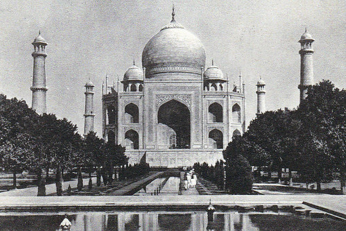
The Taj Mahal, the most famous picture of the postcards featured. The "Crown of Peace" is a mausoleum close to the Yamuna River, Agra, Indian. Built between 1632 -53 as a tomb by Mughal Emperor Shah Jahan for his favourite wife Mumtaz Mahal.
A late addition to the postcards I uploaded on the 23rd May 2020, is the following one, I missed when writing the post.
Please take a moment to share this post, follow me on social media and explore my work on Photo4Me and Clickasnap using the links below, Your support means a lot!
I'm thrilled to share a new project I've been working on that's really close to my heart: a series of three YouTube videos featuring historic pictures of Sowerby Bridge.
These aren't just any old photos; they're a window into our town's past, spanning the last 150 years! I recently came across a fantastic collection of images, and I've been advised they're all public domain and copyright-free. Some of these even belong to a Lilywhites postcards collection, meaning they're over a century old – imagine the stories they could tell!
My aim with these videos is to bring a bit of Sowerby Bridge's rich history to life for everyone to enjoy. You'll see familiar landmarks and perhaps even discover areas of the town as they looked generations ago.
Of course, if I've been misinformed about any copyright, please don't hesitate to let me know. I'm more than happy to credit the source or remove any picture at your request.
Please take a moment to share this post, follow me on social media, and explore my work on Photo4Me and Clickasnap using the links below. Your support means a lot!
Ever wonder what your local area looked like decades ago? We've put together a fascinating video featuring 20 vintage images from at least 30 years ago, offering a unique peek into the history of Halifax and the wider Calderdale area of West Yorkshire.
This collection of photographs captures many notable landmarks and forgotten scenes that will surely spark some nostalgia. You'll see iconic spots like Wainhouse Terrace and the familiar grounds of The Shay Stadium. The video also includes a look at Thrum Hall Stadium, a place that holds many memories for local sports fans.
One particularly intriguing section features Lee Bank from a time after the Queensbury Railway had closed, but before the Lee Bank Tunnel and Viaducts were eventually removed. These images offer a rare chance to see these significant structures in their pre-demolition state.
Each picture in the video is clearly labelled with its place name, making it easy to identify these historical locations. It's a fantastic journey back in time, showcasing how much our towns and landscapes have evolved while still retaining their unique character.
So, if you're a local history buff or just curious about how things used to be, this video is definitely worth a watch!
Please take a moment to share this post, follow me on social media, and explore my work on Photo4Me and Clickasnap using the links below. Your support means a lot!
The Pickle Bridge Railway, a short-lived line connecting Bradford and Huddersfield via the outskirts of Brighouse, operated from 1881 to 1952. Its closure was attributed to significant subsidence. While two stations along the route, Bailiff Bridge and Clifton Road, ceased operation well before the line's final closure, remnants of the railway are still visible between Clifton Road and Pickle Bridge, Wyke. Unfortunately, little trace remains between Clifton Road and Anchor Pit.
The line diverged from the Calder Valley Line at Pickle Bridge Junction, situated between Norwood Green (closed 1953) and Lightcliffe (closed 1965) stations. It then traversed the impressive Wyke (Red Lion) viaduct, originally boasting 22 arches, but now reduced to 8 after the northern 14 were demolished in 1987 due to ongoing subsidence. Bailiff Bridge station (1881-1917) served this section. Continuing southward, the line crossed the still-standing 5-arch Thornhills Viaduct, followed by a now-demolished viaduct at Clifton. The 3-arch Clifton viaduct led directly into Clifton Road station (1881-1931). Beyond Clifton Road, the line bridged the A644 Wakefield Road and the River Calder before reconnecting with the Calder Valley Line at Anchor Pit Junction, between Brighouse (1840-1970, reopened 2000) and Cooper Bridge (1840-1950) stations.
Photographs documenting the line's former route, captured in 2014 between Clifton Road Station and the main line at Wyke using a Polaroid iS2132 bridge camera, have been compiled into a YouTube slideshow. The slideshow is accompanied by William Rosati's musical piece, "Reception".
Just press play, the slideshow is 3 minutes 18 seconds long. And runs in an order of walking the track bed from Clifton Road to Wyke.
The video remains the copyright of Colin Green.
Thanks for looking, please take a moment to share and follow me on social media.
Images from Calderdale is a YouTube slideshow I uploaded today set to music. It features 60 pictures taken within the boundaries of Calderdale from Walsden to Brighouse, and from Warley to Norland. They were all taken over a period starting in 2013 up to December 2017 and include many notable local landmarks.
A full list of place names can be found underneath the slideshow on YouTube. The images refresh every 8 seconds and has a background soundtrack, please mute the music if not to your taste.
Thanks for looking, please take a moment to share and follow me on social media.