The sun began its slow ascent over the moorland, painting the sky in a blaze of gold and orange. The air, still cool from the night, held the promise of another warm day. But this wasn't just any sunrise; this was a moment of revelation at Baitings Dam, a reservoir that had, for a brief time, relinquished its hold on a forgotten piece of history.
Constructed to quench the thirst of Wakefield, Baitings Dam stands as a testament to human ingenuity. Completed in 1956 after eight years of arduous work and a cost of £1.4 million, it's the higher of two dams that harness the flow of the River Ryburn. Its lower sibling, Ryburn Dam, built in 1933, shares the task of supplying water to the city.
But with its completion came a bittersweet sacrifice: a small hamlet named Baitings was submerged beneath its rising waters. And with it, an ancient packhorse bridge, a vital link between the historic counties of Lancashire and Yorkshire, was lost to sight. Or so it seemed.
As I arrived on the morning of August 19th, 2022, the low water level—a result of the summer's heat—had performed a spectacular act of unveiling. The exposed, cracked earth of the reservoir bed stretched out before me, a stark contrast to the shimmering water that remained. And there, revealed in all its stoic glory, stood the old packhorse bridge.
For decades, this bridge has been a ghostly landmark, its existence a matter of local lore. While sensationalized reports claimed its first appearance in over 50 years, locals know better. This was not a unique event, but rather a more frequent occurrence in recent years, a consequence of the recurring summer heatwaves that are becoming the new norm in the UK. I’ve seen it at least three times in the last few years alone.
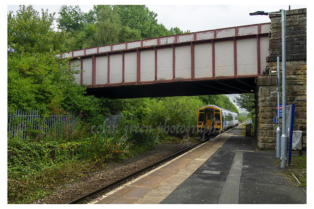
Standing by its side is a more modern successor: the concrete structure of Back O'th Heights Bridge. This bridge, with its sturdy pillars reaching down to the current waterline, offers a powerful visual lesson. The tell tale marks just beneath the road level show just how high the water can rise, a humbling reminder of the dam’s true capacity. When full, Baitings Dam holds an astounding 113 million cubic feet of water, or over 700 million gallons.
The River Ryburn, born from the run-off of the surrounding moorland, begins its journey here, flowing down the valley to eventually meet the River Calder at Sowerby Bridge, about six miles away. The dam is an integral part of this local landscape, and seeing it in this state of low ebb offered a unique perspective on its scale and the history it holds.
As the sun fully crested the horizon, its light caught the water's surface, creating a dazzling golden path that led directly to the rising sun. The pylon lines, a modern addition to the landscape, stretched across the sky, their silhouettes a stark line against the brilliant morning light. It was a beautiful, almost surreal scene.
For a photographer, Baitings Dam in this state is a dream. Every detail, from the cracked earth to the exposed foundations of the modern bridge and the newly visible old packhorse bridge, tells a story. And on this particular morning, using my Nikon d3300, I had the privilege of capturing a few chapters of that story as it unfolded under the golden light of a new day.
Clicking any of the images below should open a link in another window to my Colin Green Photography store on Zazzle.

 |
| The tide marks underneath Back O'th Heights Bridge show the dams level when full. |
 |
| The former bridge is submerged for most of the year, it's appearances becoming more frequent in recent years. |

 |
| The former bridge can be seen beyond it's replacement, this gives an idea of how low the water level has dropped due to the recent dry weather. |

 |
| The waterless back of the dam beyond the former bridge, the water level normally hiding the river that feeds it. |


 |
| I took this further up the A58 towards Rochdale, looking across the fields in the direction of the bridges and Baitings Dam. |
Please take a moment to share this post, follow me on social media, and explore my work on Clickasnap and Photo4Me using the links below. Your support means a lot!


All the images remain the copyright of Colin Green.