Sunday, 21 August 2022

An Autumnal Walk: All Saints Church, Salterhebble

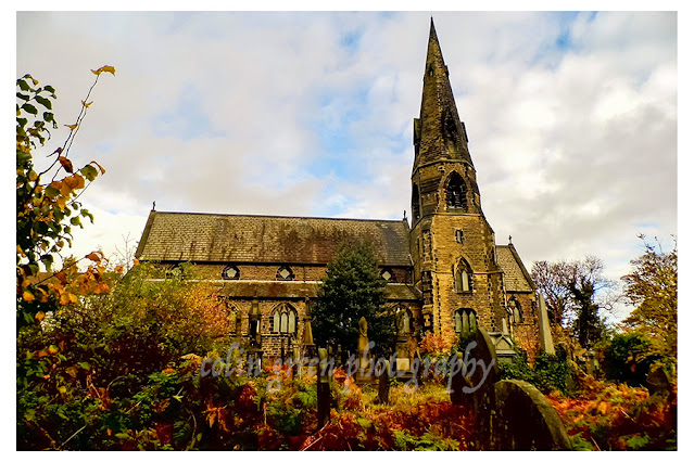
The crisp air, the rustle of fallen leaves underfoot, and the warm, low light of an autumn day create the perfect atmosphere for a journey back in time. On October 24, 2014, I found myself drawn to the timeless beauty of All Saints Church in Salterhebble, Halifax. Armed with my Polaroid is2132 bridge camera, I set out to capture the essence of this historic place, and the resulting images tell a story of faith, community, and the passage of time.

As you approach the church, the first thing that strikes you is the sheer presence of the building. The tall, elegant spire reaches towards the sky, a beacon of faith built from the local stone. It’s no wonder that a significant part of its construction was a community effort, with Samuel Rhodes generously providing over 400 cartloads of stone from his own quarry. This collaborative spirit is etched into the very fabric of the church.

Designed by the prolific architects James Mallinson and Thomas Healey, whose work can be seen in several other churches in the area, All Saints Church is a testament to the Victorian Gothic Revival style. The pointed arches, intricate stonework, and stained-glass windows are all hallmarks of this architectural movement, designed to evoke a sense of awe and reverence. The foundation stone was laid on August 26, 1857, and the church was consecrated and opened for worship the following year, in 1858. It has been a continuous place of worship ever since, its walls having witnessed generations of baptisms, weddings, and funerals.

Walking through the churchyard is a contemplative experience. It’s an overgrown, verdant space, where ancient headstones, some leaning and weathered with time, are partially reclaimed by nature. The sepia tones of the photographs capture this sense of history and quiet decay, highlighting the ornate crosses and memorials that stand as silent sentinels. A path, strewn with fallen leaves, winds its way between the graves, inviting you to wander and reflect.

One of the most remarkable sights in the churchyard is a large, ornate memorial, a striking contrast to the more traditional headstones. This is a mausoleum, a grand statement of remembrance and a captivating piece of architecture in its own right. With its intricate arches and detailed carvings, it stands as a testament to a significant person or family from the parish's past.

Another discovery was a hidden gateway, a small archway in a stone wall, half-covered in thick foliage. It felt like a portal to another world, a secret entrance to a part of the church grounds less travelled. The vibrant greens of the leaves, still holding onto their colour in the autumn light, create a beautiful frame for the simple stone steps that lead you through.

The images taken that day, some in rich colour and others in a timeless black and white, capture the dual nature of All Saints Church. It is both a functioning place of worship and a living, breathing piece of history. The autumn colours highlight the beauty of the surrounding nature, while the monochrome images emphasize the architectural details and the solemnity of the graveyard.

As I left All Saints Church that day, I felt a deep appreciation for its enduring presence. It’s more than just a building; it’s a repository of stories, a link to the past, and a quiet haven in the bustling world. It stands as a powerful reminder of the community that built it and the history that continues to unfold within its walls.

Clicking any of the images below should open a link in another window to my Colin Green Photography store on Zazzle.


Please take a moment to share this post, follow me on social media, and explore my work on Clickasnap and Photo4Me using the links below. Your support means a lot!


All the images remain the copyright of Colin Green.

Saturday, 20 August 2022

Unveiling History: A Dawn Walk at Baitings Dam

The sun began its slow ascent over the moorland, painting the sky in a blaze of gold and orange. The air, still cool from the night, held the promise of another warm day. But this wasn't just any sunrise; this was a moment of revelation at Baitings Dam, a reservoir that had, for a brief time, relinquished its hold on a forgotten piece of history.

Constructed to quench the thirst of Wakefield, Baitings Dam stands as a testament to human ingenuity. Completed in 1956 after eight years of arduous work and a cost of £1.4 million, it's the higher of two dams that harness the flow of the River Ryburn. Its lower sibling, Ryburn Dam, built in 1933, shares the task of supplying water to the city.

But with its completion came a bittersweet sacrifice: a small hamlet named Baitings was submerged beneath its rising waters. And with it, an ancient packhorse bridge, a vital link between the historic counties of Lancashire and Yorkshire, was lost to sight. Or so it seemed.

As I arrived on the morning of August 19th, 2022, the low water level—a result of the summer's heat—had performed a spectacular act of unveiling. The exposed, cracked earth of the reservoir bed stretched out before me, a stark contrast to the shimmering water that remained. And there, revealed in all its stoic glory, stood the old packhorse bridge.

For decades, this bridge has been a ghostly landmark, its existence a matter of local lore. While sensationalized reports claimed its first appearance in over 50 years, locals know better. This was not a unique event, but rather a more frequent occurrence in recent years, a consequence of the recurring summer heatwaves that are becoming the new norm in the UK. I’ve seen it at least three times in the last few years alone.

Standing by its side is a more modern successor: the concrete structure of Back O'th Heights Bridge. This bridge, with its sturdy pillars reaching down to the current waterline, offers a powerful visual lesson. The tell tale marks just beneath the road level show just how high the water can rise, a humbling reminder of the dam’s true capacity. When full, Baitings Dam holds an astounding 113 million cubic feet of water, or over 700 million gallons.

The River Ryburn, born from the run-off of the surrounding moorland, begins its journey here, flowing down the valley to eventually meet the River Calder at Sowerby Bridge, about six miles away. The dam is an integral part of this local landscape, and seeing it in this state of low ebb offered a unique perspective on its scale and the history it holds.

As the sun fully crested the horizon, its light caught the water's surface, creating a dazzling golden path that led directly to the rising sun. The pylon lines, a modern addition to the landscape, stretched across the sky, their silhouettes a stark line against the brilliant morning light. It was a beautiful, almost surreal scene.

For a photographer, Baitings Dam in this state is a dream. Every detail, from the cracked earth to the exposed foundations of the modern bridge and the newly visible old packhorse bridge, tells a story. And on this particular morning, using my Nikon d3300, I had the privilege of capturing a few chapters of that story as it unfolded under the golden light of a new day.

Clicking any of the images below should open a link in another window to my Colin Green Photography store on Zazzle.


The tide marks underneath Back O'th Heights Bridge show the dams level when full.

The former bridge is submerged for most of the year, it's appearances becoming
more frequent in recent years.


The former bridge can be seen beyond it's replacement, this gives an idea of how low
the water level has dropped due to the recent dry weather.


The waterless back of the dam beyond the former bridge, the water level normally
hiding the river that feeds it.


I took this further up the A58 towards Rochdale, looking across the fields in the direction
of the bridges and Baitings Dam.

Please take a moment to share this post, follow me on social media, and explore my work on Clickasnap and Photo4Me using the links below. Your support means a lot!


All the images remain the copyright of Colin Green.

Burnley Barracks: A Hidden Gem on the East Lancashire Line

Ever heard of a request stop? It's a bit like an old-fashioned bus stop, but for trains. You have to actively let the driver know you want to get on or off. That's exactly the kind of place Burnley Barracks is—a small, unassuming station on the East Lancashire Line, but one with a surprisingly rich history.

The station, which opened way back in 1848, was originally known as Burnley Westgate and served as the temporary terminus for the line. It was only meant to be a short-lived stop, but the rapid development of the area, including a new army barracks, led to its reopening in 1851. Renamed Burnley Barracks after the nearby military base, the station became a local hub, serving passengers while the larger stations at Rose Grove and Bank Top (now Burnley Central) handled the freight.

Today, Burnley Barracks is a simple affair. As you can see from the photos, the station has a single platform, a basic shelter, and a card-only ticket machine. It offers step-free access and relies on on-street parking, but its charm lies in its simplicity. It’s a quiet spot, often overlooked, but it's a vital link for the local community.

The station's history is written in its very structure. The old eastbound platform, which was taken out of use when the line was singled in 1986, is now largely overgrown and hidden from view. It's a subtle reminder of a busier past, a time when the station had two platforms and a footbridge connecting them.

While passenger numbers have fluctuated over the years—dropping significantly after the army barracks closed in 1898 and local slum clearances in the 1960s and 70s—they've been on the rise in recent years. This is thanks to new housing developments and a growing trend of people opting for public transport over their cars.

Burnley Barracks is more than just a stop on the line; it’s a living piece of local history. It's a testament to the changes in the area, from its military past to its modern residential communities. On my recent visit, it was the busiest of the eight stations I visited on the East Lancashire Line, with several passengers boarding and alighting the train.

There's a proposal to close the station should the line be upgraded, but for now, Burnley Barracks remains a quiet, functional, and fascinating part of the railway network. It’s a small station with a big story, a true hidden gem just waiting to be discovered.

So next time you're on the East Lancashire Line, why not make a request stop at Burnley Barracks? You might just find yourself stepping back in time.

The pictures were taken with a Nikon d3300 on the 19th August 2022, clicking any of them below should open a link in another window to my Colin Green Photography store on Zazzle.

Colne bound training just leaving. It would 45 minutes before another train passed through the station.
There is 1 train in each direction approx. every hour.

The entrance sign to the station

The station looking west from the end of the platform. Despite Junction Street Bridge (Foreground)
and Padiham Road Bridge (Background) passing over the station, the 2 platforms were connected
by a wooden passenger bridge sighted between the 2. I assume this was removed when the line
was singled in the 1980's, but it may have been earlier as there is evidence on another site entrance
just off Junction Street Bridge.


The station looking eastward (towards Colne) from the end of the platform. The stations only
facilities are the shelter seen before the bridge and a ticket machine to my right
just out of shot.

Please take a moment to share this post, follow me on social media, and explore my work on Clickasnap and Photo4Me using the links below. Your support means a lot!


All the pictures remain the copyright of Colin Green.

Friday, 19 August 2022

A Sunrise Walk at Baitings Dam

There's a certain magic to an early morning walk, especially when you're there to witness a landscape change before your eyes. Baitings Dam has been a regular fixture in the local news lately, with the unusually low water levels exposing secrets that are usually hidden beneath the surface. While some reports claim the old packhorse bridge has been seen for the first time in 50 years, that’s not quite right. In a world of changing weather patterns, what was once a rare sight is now happening every couple of years.

Just a few days ago, on August 19, 2022, I got up before the sun to capture a moment that beautifully illustrates this change. With my Nikon D3300 in hand, I headed to the dam, a place I often walk my dogs. As the sun began to rise, it cast a golden light over the landscape, illuminating a scene that tells a story of both nature and human history.

In the foreground, the original packhorse bridge stands revealed. This historic crossing once spanned the River Ryburn, long before the construction of Baitings Dam was completed in 1956. It's a humbling sight, a testament to a time when travel and trade relied on these simple, sturdy stone structures.

Just behind it, the more modern Back O'th Heights bridge seems to float above the water, a new path built for a new era. When the dam is full, the water level comes within just a couple of feet of this bridge, making the presence of the old one below even more remarkable.

As the sun climbed higher, it bathed the entire scene in a stunning glow. Its light caught the dam's headwall in the distance, a massive structure holding back the water that has both created this modern reservoir and submerged the landscape of the past.

This sunrise at Baitings Dam was a powerful reminder that history is not just found in museums or books; it's often right beneath our feet, waiting for the right moment to be revealed.

Please take a moment to share this post, follow me on social media, and explore my work on Clickasnap and Photo4Me using the links below. Your support means a lot!


The picture remains the copyright of Colin Green.

Thursday, 18 August 2022

An Underground Oasis: Discovering Jameos del Agua in Lanzarote

On July 30, 2013, with my Samsung Galaxy Tablet, I had the pleasure of exploring one of Lanzarote's most extraordinary attractions: Jameos del Agua. This unique site is a brilliant fusion of art, nature, and architecture, born from a collapsed volcanic tube and transformed into a cultural center by the visionary artist and architect, César Manrique.

The journey begins as you descend into the cool, dark embrace of the earth. The air, thick with the scent of salt and rock, leads you into a subterranean world. The most captivating sight is the saltwater lake, a tranquil body of water nestled deep within the cavern. Its waters are home to a rare and fascinating creature: the squat lobster. These tiny, white, and blind crustaceans are an endemic species, found nowhere else on Earth. Peering into the crystal-clear water, you can spot them scuttling along the rocks, a silent community thriving in the perpetual darkness.

Further into the cavern, the space opens up, revealing a breathtaking auditorium carved directly from the volcanic rock. The stage and seating are a testament to Manrique's genius, blending seamlessly with the natural contours of the cave. I can only imagine the incredible acoustics and the magical atmosphere of a concert held in such a unique venue.

Emerging from the depths, you are greeted by an explosion of light and color. The path leads to a sun-drenched pool area, a stark and beautiful contrast to the dark cavern below. The stunningly white pool, surrounded by black volcanic rock and vibrant green palms, is an image of pure, tranquil beauty. It is said that only the King of Spain is allowed to swim in this pool, adding to the mystique of the place.

The gardens surrounding the pool are a lush haven, with native plants thriving in the volcanic soil. As you climb the stairs, you are treated to a view of the pool from above, and the unique architecture continues to impress. The stairs themselves, with their abstract design and a natural light source filtering down from an opening in the cave ceiling, feel like a piece of art in their own right.

Jameos del Agua first opened to the public in 1966, and it truly embodies César Manrique’s philosophy of harmonizing art with nature. By preserving the natural landscape and enhancing it with his creative touch, he created a place that is not just an attraction, but an experience. It's a reminder of the power of art to transform, and the incredible beauty that can arise when we work in harmony with the natural world.

Clicking any image below should open a link in another window to my Colin Green Photography store on Zazzle.

The lobster sign at the entrance.
The swimming pool area, the guide I was with claimed that only the King
of Spain is allowed to swim here.

The stairs up from the saltwater cave to the swimming pool
and bar area.

The auditorium, the guide claimed gives one of the best sounds around.


The saltwater cave that is home to the squat lobster.

Please take a moment to share this post, follow me on social media, and explore my work on Clickasnap and Photo4Me using the links below. Your support means a lot!


All the pictures remain the copyright of Colin Green.

Wednesday, 17 August 2022

Revisited: A Glimpse into Britain's Hidden War History

I've always been fascinated by the quiet, unassuming places that hold powerful stories from our past. Years ago, I visited the remains of a World War II Operation Starfish site near Sowerby. On August 16, 2022, armed with a much better camera—my Nikon D3300—I decided to return, knowing that while the scenery would be the same, the story it told would feel just as poignant.

And in many ways, nothing had changed. The sprawling moorland landscape remained a beautiful, desolate expanse. The old brick bunker, a silent sentinel on the hill, was exactly as I remembered it. The only real difference was the unfortunate addition of more rubbish and a bit of minor damage to the brickwork, a sad mark left by time and neglect.

This remote spot was once part of a crucial large-scale deception plan known as Operation Starfish. Developed by Colonel John Turner after the devastating bombing of Coventry in November 1940, the plan was a brilliant, if simple, ruse to protect Britain's cities. The idea was to create large-scale decoys that would mimic the glow of bombed-out cities and industrial targets, tricking German bombers into dropping their payloads in harmless, open countryside.

The sites were strategically located about four miles from their intended targets. In the fields surrounding the bunker, metal troughs were hidden, ready to be filled with a volatile mix of creosote, coal, and diesel oil. When enemy bombers were overhead, these troughs would be set alight, creating a convincing imitation of a city on fire. After a short period—usually about 15 minutes—water would be added to the fire, causing a burst of flames and smoke that mimicked a secondary explosion, signaling a direct hit to the bombers flying high above.

The Sowerby site was specifically designed to be a decoy for major industrial centers and railway junctions. Its blazing fires would have been intended to lure bombers away from the cities of Manchester and Leeds, as well as the vital railway goods yards in nearby Greetland, Halifax, Todmorden, Littleborough, and Rochdale.

At the heart of the operation was a two-room bunker, which, remarkably, still stands today. Protected by a blast wall, it would have been a small, claustrophobic space where the brave men operating the decoy would have lived and worked, orchestrating the fiery deception. The images I took, particularly those from inside the bunker, show a space now filled with rubble and rubbish, a stark contrast to the purpose it once served. Yet, even in its neglected state, you can feel the history, the tension, and the ingenuity that once existed within those walls.

These hidden relics of Operation Starfish serve as powerful reminders of the lengths to which a nation will go to defend itself. They are memorials not of grand battles, but of quiet, strategic brilliance, and of the forgotten individuals who played a crucial part in protecting their country.

Clicking any of the images below should open a link in another window to my Colin Green Photography store on Zazzle.


The blast door pictured in front of the bunkers main entrance

Inside the bunker on the left hand side of the entrance is this former control
room. Now filling up with rubbish that has been left behind.

Looking north over the bunker. In the foreground can be seen some
brickworks, probably housed washrooms and generators. Their isn't much
evidence of the site ever being linked to mains electric.


The former control room to the right hand side of the entrance.

Looking west away from the bunkers entrance, taken from the roof I
assume the site in front of me would have housed the metal pans
that created the dummy lighting effect.

Please take a moment to share this post, follow me on social media, and explore my work on Clickasnap and Photo4Me using the links below. Your support means a lot!


All the pictures remain the copyright of Colin Green

Time Travel to 1974: A Peaceful Scene at Barrowford Locks

There's a gentle magic to slides that precisely transport you back to a specific moment. This 35mm slide from my collection, dated to 19...