Copley Valley is an area of Calderdale to the east of Sowerby Bridge, redeveloped in the early 2010's as industrial, housing and nature reserve.
Prior to the development the area was more commonly known as Milner Royd and you could find the remains of the Sowerby Bridge Sewage Works, a large dam which was popular with anglers until it was drained, Sterne Bridge (Built 1914), the old Standard Wire Factory and an area teaming with wildlife and nature. The area is bordered by the railway to the south, split down the middle by the River Calder and again bordered to the north by the Calder & Hebble Navigation Canal.
The pictures were taken in 2014 whilst the redevelopment was ongoing, the new road and bridge having been built and land set aside for the building of new industrial units, there are 5 which can be seen below or on ClickAsnap where they are full size, resolution and un-watermarked.
Berkswell Railway Station is a 2 platform stop on the West Coast Mainline serving the villages of Berkswell and Balsall Common near Coventry, West Midlands.
The London and Birmingham Railway was completed in 1839 passing near to the village of Berkswell but not having a stop until the first one was opened as Dockers Lane in 1844. The name was changed to Berkswell in January 1853, again in February 1928 to Berkswell and Balsall Common, the station being sighted closer to Balsall Common than Berkswell. The name was again changed back to Berkswell around 1959 when works started along the line to electrify, these being completed in 1974. The station was also remodelled during this period.
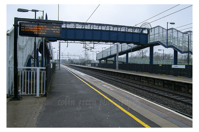
The station used to be a junction with a line that ran in the direction of Kenilworth just to the south of the station with the siding track that the trains used to run still visible. This line was in operation from 2 March 1884 until 3 March 1969 and is now in the process of being converted into a greenway. The siding still visible sometimes houses the Royal Train and members of the "Firm" have been known to overnight on the train whilst parked in the siding. Sir Winston Churchill is also said to have stopped in the siding overnight.
The station used to feature a level crossing to the south of the platforms, this was removed in 2004 and replaced by a bridge so the station and line could feature more high speed trains. The station is manned during selected hours has minimal facilities, including waiting room and ticket machines, but no toilets. There is a car park and the station is served by 2 trains per hour in each direction. Theses services go north to Birmingham New Street and south to London Euston. The station saw 334,000 passengers use it during 2019/20 period, the last before the Covid pandemic, before dropping to just 52916 during the first year of the virus.
Filmed on a Samsung Galaxy Tablet in July 2013, the Sea Lions at the Texas Rancho Park was a sea lion show to show the intelligence and skills that sea lions have. The show features Patagonian and Californian Sea Lions who show off their playful and noisy nature whilst performing for the public. The video was filmed by my daughter. Whilst not particularly being a fan of animals being caged in what I assume is not their natural habitat, the sea lions seemed happy enough whenever I saw them during the shows that were performed that day.
Thanks for looking and please take a moment to share, the video can also be seen on my YouTube Channel. It remains the copyright of Colin Green. Please take a moment to follow me on social media and YouTube.
Copley Toll Booth is now a private residence that stands to the south of present day Wilson Bridge, but in 2013 stood at the end of the s arch stone Copley River (Toll) bridge. The booth was built circa 1831 when the bridge was constructed. This picture can be seen on my Clickasnap Profile un-watermarked, full size and resolution.
The above fee board could be found on the side of Copley Toll Booth when I visited in 2013, I am not sure if the board is still there.
This picture taken stood towards the end of Copley River (Toll) Bridge shows the Toll Booth to the right, and to the left is the lych-gate to St Stephens Church, Copley. North Dean Woods can be seen beyond and the road heads in the direction of Norland and Greetland.
A scene that can never be repeated is this one of the Copley River (Toll) Bridge. The roof of St Stephen's Church can be seen with North Dean Woods behind.
Copley River Bridge was a 2 arch stone bridge that carried North Dean Road across the River Calder. The bridge was was built by Richard Kennett-Dawson, the last Lord of the Manor of Copley. The bridge was constructed in 1831 and a fee was charged to cross, this was abolished in 1856. The bridge stood for 184 years until the Calder Valley was devastated by flooding on Boxing Day 2015. The bridge was badly damaged and eventually the decision was taken to demolish the remains. A replacement steel single span bridge was constructed and opened in 2017, the bridge was named Wilson Bridge after Graham Wilson who had lived in the toll house until his death in 2017. The new bridge only allows crossing for pedestrians, cyclists and horses, motorised vehicles are prohibited.
All the pictures except the toll price list can be seen on my Clickasnap account where they are full size, resolution and un-watermarked. Please take a moment to share and follow me on social media.
All images are the copyright of Colin Green, please credit me if using any of them.
In July 1844 Halifax celebrated as the first single track line to reach the town arrived, terminating at Shaw Syke near to the current B and M store, the town had finally joined the railway revolution. The line had been constructed from the Manchester and Leeds Railway at Greetland along the the current route that passes by Salterhebble. By August 7 1850 the line had been extended to Bradford and a new station was opened with temporary buildings at its current location, the Shaw Syke site now being developed as a goods yard.
The temporary station was replaced by permanent stone buildings which were designed by Thomas Butterworth, these opened on the 23 June 1855 and Halifax now had a station to be proud of. The station became a junction station in the 1870's when the Great Northern Railway constructed the Queensbury Line to Keighley and Bradford. The line branching off just beyond the end of the platform over a viaduct in the direction of North Bridge Station. This new venture led to the station being redesigned and a new access bridge crossing the much enlarged station beneath, by this time it had grown to a station of 7 platforms.
Due to the growth of the railways in Halifax the station was renamed in June 1890 as Halifax Old Station to distinguish it from Halifax North Bridge and Halifax St Paul's Station's, it was renamed in September 1951 as Halifax Town Station, and again in June 1961 back to just Halifax after the closures of the St Paul's and North Bridge Station's.
The station was greatly reduced in size over the next few years, eventually becoming a 2 platform island station with poor facilities and access. The local paper the Halifax Evening Courier eventually started a campaign for a station fit for the 21st century which led to Northern and Network Rail investing in repairs and refurbishment of the stations facilities. In October 2014 there was a plan to restore the 1855 building as a third platform to improve services from the building, but the seems to have stalled whilst Calderdale Council plan a near £30 - £40 million development that will remove the bridge and higher access station, add ground level access, retail and facilities and supposedly give an all round much better experience for travellers. Personally I will believe it when I see it, our local council always seem to manage to make a bad project out of a good idea.
The station currently offers direct trains to Bradford, Huddersfield, Leeds and Manchester, with additional services to Chester Hull and London. The station is manned with ticket counters in addition to ticket machines. There is a small retail shop and a toilet if required, the station is not step free access but there is a lift down to platform level, I believe when there are staff in attendance. Before the pandemic hit the station saw approx 1.914 million passengers a year, an average of approx. 36800 per week. The last full year of figures during the Corona Virus era saw an average of approx 7000 per week using the station.
These pictures were taken in November 2013 using a Samsung Galaxy Tablet.
Scarborough is a seaside resort in Yorkshire, Northern England. It is the largest town resort town in North Yorkshire and grew around the industries of fishing and tourism. The following video shows a number of postcards that feature various images of the town with some highlights including images of,
Scarborough South Bay Bathing Pool
The construction of the south bay bathing pool was the brainchild of Harry W. Smith the former borough engineer for Scarborough. Whilst on a visit to Guernsey he became inspired by an outdoor pool they already had for bathers. Upon his return he proposed a pool that would feature different depths, diving boards, water chutes, changing rooms and showers, these would have been a first for Britain not just Scarborough. Construction started before World War One and the pool officially opened in 1915. The pool was built to help combat coastal erosion and was filled by fresh sea water daily due to the tides. The pool was a popular attraction until its closure in the 1980's when the site fell in to disrepair.
Scarborough North Bay Pier
Opened on the 1st May 1869, the North Bay Pier was constructed by Josiah Foster Fairbank as a steamer and promenade pier. Upon completion the pier reached a length of 1000ft (305m) out to sea, but was dogged by incidents from the start, frequently being hit by steamers at the head and never making much money, the pier changed owners several times and January 7 1905 a storm wrecked a large section of the pier leaving only the head and entrance standing. The pier closed after this and shortly after the head was demolished, with the entrance pavilion itself being demolished in 1914.
Peasholm Park
The video also features a number of images of Peasholm Park, opened in 1912 the park attractions include Peasholm Glen, putting green, boating lake where mock naval battles are staged 3 times a week during the high season and many types of plant life to walk around and enjoy. The park declined from the 1970's on and was closed for a time when fire destroyed some of the buildings in 1999. Due to heritage lottery funding the park has since been restored and is now a popular attraction again.
Other scenes of interest include the Turkish Baths, Floral Hall, Railway Station and Open Air Theatre. There are a total of 25 pictures to view taken from postcards.
Thanks for looking and please take a moment to share, and follow me on social media.
The Rialto Bridge is the oldest crossing of the Grand Canal in Venice, Italy. One of 4 crossing points the bridge connects the districts of San Marco and San Polo. The current bridge made of stone began construction in 1588 and was completed in 1591, it is the last of several to have occupied this area of Venice and was built by Antonio da Ponte following a competition to design a new bridge.
The bridge is a major tourist attraction reachers a length of 31.8 metres (104.3ft), a height of 7.32 metres (24ft) and a width of 22.9 metres (75.1ft). There are 2 arcades of shops across the bridge separated by a central pathway of steps with another 2 paths to the rear of each row of shops. To support the bridge arch over 6000 timber piles were driven in to the soft embankments under each abutment.
The first bridge to cross the Grand Canal here was was the Ponte della Moneta, built as a pontoon bridge with ships fastened together and designed by Nicola Barattieri in 1181. This bridge was replaced in 1255 by a wooden construction because the nearby Realto market had grown considerably, this bridge had a movable platform in the middle to allow ships to pass. This bridge was the first to include shops who's taxes and rents helped with paying for the maintenance, it was during this time the bridge name was changed to Realto after the nearby market.
In 1310 the bridge was badly damaged by fire during the attempt to overthrow the Doge by Bajamonte Tiepolo and in 1444 it collapsed during the wedding celebration of the Marquis Ferrara. This led to the bridge being rebuilt as a drawbridge but once again in 1524 the bridge collapsed. In 1551 the authorities invited the most famous architects of the era to offer their ideas for a bridge, and in 1588 work started on the current bridge which was approved due to the design being of a single span arch. Many people doubted the bridge would last but so far it has stood for over 400 years and counting.
These pictures were taken on the 1st November 2018 using a Nikon d330 SLR camera, they can also be on Clickasnap by clicking any image, link will open in another window.
Thanks for looking and please take a moment to share and follow me on social media.
All the pictures remain the copyright of Colin Green.
Tile Hill Railway Station is unusual for in that it only features 1 pictures which was snapped quickly when arriving at the station to catch my train to Berkeswell, my train was just arriving. I am unlikely to return living some 100 miles away so will probably never add to it.
Tile Hill serves the suburbs of Coventry, in the West Midlands and is on the main line railway between London Euston and Birmingham New Street Stations. The station opened as Allesley Lane in 1850, before changing names to Allesley Gate in 1857 and finally assuming the name Tile Hill on April 1 1864. Built with staggered platforms either side of the Cromwell Lane level crossing the station remained unchanged until the 1960's when the electrification of the main line resulted in the station being completely rebuilt in its current form. The level crossing was replaced by a bridge in 2004 and the platform connecting bridge was constructed at the same time.
The station has a ticket office which is open at various times 7 days a week, there are 2 trains per hour in the directions of Birmingham and London. The station has always been a busy station averaging approx 700,000 passengers per year until a combination of developments of the car parking and the current Covid 19 virus situation saw number drop to just 107,000 during the most recent period 2020-21, an average reduction of approx 11,000 passengers per week.
The picture was taken using a Nikon d3300 SLR on January 18 2017.
Clicking the image will open a link in another window to the higher resolution, un-watermarked version of the picture on Clickasnap.
Thanks for looking, please take a moment to share and follow me on social media.
The Leeds and Liverpool Canal is a 127 mile long canal that crossers the Pennines linking Leeds with Liverpool. Along it's route it passes many famous northern towns including Bramley, Shipley, Saltaire, Bingley, Keighley, Skipton, Nelson, Burnley, Blackburn, Leigh, Wigan and Aintree amongst many others.
The section I pictured was a short stretch from Bridge 199 to the bottom of the famous Five Rise Locks at Bingley, this being the first phase of the canal to be completed in 1773 from near to the top of the locks to Skipton, the locks opening in 1774 when the canal had been extended to Shipley.
All the pictures were taken on the July 9 2016 using a Nikon d3300 SLR camera. The first set shown were taken on the canal between Bridge 199 and the Five Rise Locks Cafe, more on the Five Rise Locks further down the page.
The Five Rise Locks are a staircase Lock that rises at a gradient of 59.2ft in a distance of just 320ft, these are the steepest flight of locks in the United Kingdom. The locks have a full-time lock keeper due to the complicated nature of navigating the five locks up or down, they require a lot of maintenance and often close during the quieter winter months to enable this.
The locks are Grade I listed having been granted this status on the August 9 1966, they were opened on March 21 1774 and it is said a crowd of over 30000 people turned up to celebrate the major feat of engineering, the first boat to navigate the locks took 28 minutes.