Sunday, 10 September 2023

Venice, Italy 30th October 2018 Set 2

 The following post features images taken whilst in Venice, Italy on the 30th October 2018, the images are of various 1 shot locations around the city and I felt their wouldn't be enough about them to do a full post on each place pictured. I spilt the images into 2 post's with the first set released earlier this year featuring 16 images and this set below featuring 20 pictures.

I have tried where possible to give a location as to where the picture is, I used Google Maps to try and help me find each location so hopefully I got them right.

The pictures were taken using a Nikon d3300 camera. Clicking any image should open a link in another window to to the higher resolution, un-watermarked version on Clickasnap.


Ponte di Canonoica.


The Bridge of Sighs from the Ponte di Canonica, the canal is the Rio del Palazzo.


Calle Larga L'Ascension, I took this just off San Marco Square looking towards the waterfront.


Rio Orseolo del Coval and the Hotel Cavalletto.


Calle Tron.


Bell Tower of Chiesa dei Santi Apostoli.


Ponte de San Paternian over the Rio di San Luca Canal.


This doorway and mural were in the same entrance hall area, I think they were taken either in the Accademia Bridge or San Marco Square areas of Venice.


Grand Canal Gondola Mooring at Calle della Carita.


Ponte de le Maravegie, the bell tower is the Campo San Trovaso


Cannaregio Canal.


Leonardo da Vinci Museum.


Rio del Palazzo Canal looking towards the Bridge of Sighs, the bridge between is the Ponte de Canonica.


Another of the Rio del Palazzo Canal, taken from the same bridge as above in the opposite direction.


Church of San Zaccaria.


Ponte de la Pieta on the San Marco sea front. The grey building is the Church of the Pieta.


Calle Tron at night.

Clicking any image should open a link in another window to the version on Clickasnap.

Thanks for looking, please take a moment to share and follow me on social media.

All the pictures remain the copyright of Colin Green.

Saturday, 9 September 2023

Valley Parade, Bradford.

 The following pictures were the result of my car having repairs done in a garage and me having more time than I expected to pass. I wasn't expecting to be in Bradford more than a couple of hours but my car proved more stubborn than expected and luckily I had my camera and the day wasn't too bad to pass time on.

Valley Parade is a sports stadium in the Manningham district of Bradford, West Yorkshire. Home of Bradford City since 1903 the stadium was originally the home ground of Manningham FC, the first champions of the then Northern Union(rugby league) who opened it on the site of a quarry in 1886. The ground has also been home to Bradford (Park Avenue) and Bradford Bulls RLFC during it's history.

The stadium was largely unchanged from 1908 until it became a 3 sided ground in 1952 when the Midland Road Stand was demolished due to faults found in the foundations. The problems forced the Midland Road (East) Stand to be rebuilt twice and the stadium remained largely a 3 sided ground until 1966 when the East Stand was finally completed.

The Main (JCT 600) Stand which was the scene of one of the worst disasters to occur at a sporting event on the 11th May 1985 when fire swept through the stand resulting in the deaths of 56 people and injuries to a further 265. Since the disaster the stadium has been completely rebuilt.

These pictures were taken on the 10th December 2022 with a Nikon d3300 camera, clicking any image should open a link in another window to the version on Clickasnap.

The Stadium is all seater and has a capacity of 25,136 spread across 5 stands the north western corner stand being separate to the Kop and JCT 600 stands.

The Main (West) Stand


The JCT 600 Stand also known as the Main Stand is the largest stand with a capacity of 9,004, it's unusual in that the stand only runs 3/4 of the length of the pitch, with offices occupying the last 1/4 of the pitch area. This stand also has a small uncovered area near to the offices.

The Midland Road (East) Stand

The Midland Road is a single tier stand with a capacity of 4,500, around the turn of the Millenium former chairman Geoffrey Richmond had a plan to add a second tier to the stand increasing capacity in the East Stand to 10,000. This stand is used to house away fans.

The Kop


I think this picture shows what traditional British Football Stadiums are about, having been built up around the housing that surrounds the stadium. The Kop Stand towering above the terraced housing on Rear Rock Terrace. I'm led to believe that the reason the main stand is oddly shaped is because of the right to light the houses on the eastern side of the ground enjoy prevent major development.


The Kop is the 2nd largest stand at Valley parade holding 7,492, unusually for Kop stands in British Football it has 2 tiers, traditionally Kop stands only having a single tier.

TL Dallas (South) Stand

The TL Dallas South Stand is the smallest stand at Valley Parade holding 1,840 people, it is 2 tiered and hemmed in by Holywell Ash Lane making further expansion unlikely. It is dwarfed by the rest of the stands at the ground and traditionally housing away fans.

Thanks for looking, please take a moment to share and follow me on social media.

All the images when clicked should open a link to the un-watermarked, higher resolution version on Clickasnap.

All the images remain the copyright of Colin Green.

Thursday, 7 September 2023

Whitby Piers and Beach

 Whitby has had piers helping to control tidal flows since the medieval era, the current East and West Piers having initially been built in the 19th Century, before extensions were added in the 20th.

The Grade II listed East Pier was built in 1854 and reaches a length of 1080ft, it is of sandstone construction, the West Pier is also Grade II listed, of sandstone construction but was built in 1831 and is 1178ft in length. These piers are found at the harbour entrance and were doubled in length with work completed in 1912, this was to prevent a whirlpool effect at the harbours entrance that had been affecting ships when entering the port. Both piers have lighthouses on them with the East Pier having the smaller constructed tower.

I took the pictures below on the 25th August 2018 with a Nikon d3300, the can also be seen in a 12 x 4 x 300 resolution on Clickasnap and un-watermarked.


The following picture was taken looking north from West Cliff looking over Whitby Beach in the direction of Sandsend and Kettleness. The North Sea Waves Breaking on to the beach.

Clicking any image should open a link in another window to the version on Clickasnap.

Thanks for looking, please take a moment to share and follow me on social media.

All the pictures remain the copyright of Colin Green.

Sunday, 3 September 2023

The Calder and Hebble Navigation. Ravensthorpe to Mirfield

 The Calder and Hebble Navigation is an inland waterway connecting Sowerby Bridge with Wakefield, West Yorkshire. Opened in 1770 to extend the navigational parts of the River Calder, the canal runs through 27 locks on its 21.5 mile journey from the canal basin at Sowerby Bridge to it's junction with the Aire and Calder Navigation at Fall Ings Lock, Wakefield. The canal unlike many others has never fallen out of use, with commercial traffic still using the canal until 1981, and leisure traffic increasing since the reopening of Tuel Lane lock and tunnel at Sowerby Bridge in 1996.

The pictures below were taken on the canal between Ravensthorpe Bridge and Bull Bridge, Mirfield. This stretch includes sections of cutting and river that are navigable. They were taken on the 8th April 2015 with a Polaroid is2132 camera.


This was taken just past Ravensthorpe Bridge looking in the direction of Mirfield. The navigation is on the River Calder at the moment.


The canal is still on the River Calder, the lock seen in the middle of the picture is Greenwood Lock. The lock allows traffic to leave the river section and enter Greenwood Cut.


This agian shows part of the River Calder section of the navigation, Greenwood cut is just off picture to the left.


This weir can be found at the top of Greenwood Cut End just before Shepley Bridge Marina. The canal ane river are a joint navigation for a short spur here. 


Shepley Bridge. This section of the navigation is a river and canal joint bit, the canal bears off through Shepley Lockseen near the centre of the picture underneath the bridge. The River Calder continuing beyond.


Shepley Bridge Marina, Nr Mirfield.


Shepley Bridge Marina and Lock.


Wheatley Bridge, Mirfield.


The abutments above and below used to carry the Mirfield to Low Moor Railway (Cleckheaton Branch) over the canal. The line closed in 1965 along this stretch.


Gill Bridge, Mirfield. Just saw the 2 lads fishing and quietly letting the day pass buy. I took the picture as it reminded me of my youth and attempt at fishing, I quickly learnt it's not a hobby for me.


The Calder and Hebble at Mirfield.


Bull Bridge, Mirfield.

On the day I walked the navigation from Saville Town, Dewsbury to Brighouse. I'm posted the pictures in individual post's of various sections of the canal.

Clicking any image should open a link in another window to the un-watermarked version on Clickasnap.

Thanks for looking, please take a moment to share and follow me on social media.

All the pictures remain the copyright of Colin Green.

Sunday, 13 August 2023

Old Lane Mill, Ovenden, Halifax.


Towering over Ovenden in Halifax, Old Lane Mill stands as a testament to the industrial past of Yorkshire. Built in 1825, it's not just any mill; it's the oldest surviving multi-storey, steam-powered, iron-framed textile mill in Halifax, possibly even the UK.

James Akroyd, the visionary behind Old Lane Mill, wasn't afraid to push boundaries. He incorporated innovative features like an iron frame and stone floors, allowing the mill to support the weight of the revolutionary Jacquard looms he installed in 1827. These looms, the first of their kind in Britain, marked a significant leap forward in textile production.

Despite claims of being fireproof, Old Lane Mill wasn't immune to disaster. A blaze ripped through the building in 1905, causing significant damage. However, the mill persevered, changing hands and purposes throughout the 20th century. It even served as part of the larger Dean Clough Mill complex for a time.

Today, Old Lane Mill stands derelict, a haunting reminder of a bygone era. The empty shell, though ravaged by time and vandalism, still whispers stories of innovation and industry. The stone floors, stripped-out machinery remnants, and the large engine house with its distinctive features offer a glimpse into the heart of a once-thriving mill.

The future of Old Lane Mill remains uncertain. Preservation efforts are ongoing due to the building's historical significance. Whether it's restored to its former glory or repurposed for a new life, Old Lane Mill undoubtedly deserves to be cherished as a vital piece of Halifax's textile heritage.

Please note: Due to the derelict state of the building, exploring Old Lane Mill is not recommended.

I was in the area on the 15th April 2015 and visited the mill, I made no effort to enter the building as it looks unsafe and I am not good with heights, preferring to just photograph the outside safely on the ground level. There are many others that have photographed and video the inside available to view online, and Martin Zero did an excellent video on YouTube about the mill some 3 years ago that is worth a look. The pictures were taken using a polaroid is2132 bridge camera, they can be seen below or on my Clickasnap account were they are full size, resolution and un-watermarked.


Clicking any image should open a link in another window to the un-watermarked, higher resolution version on Clickasnap.

Thanks for looking, please take a moment to share and follow me on social media.

All the pictures remain the copyright of Colin Green.

Wednesday, 9 August 2023

3 More Vintage 35mm Slides from the 1980's

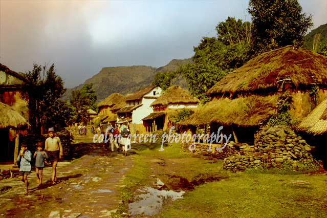
 I am currently digitising, re-editing and restoring my collection of 35mm slides for sharing on Clickasnap and the pictures below are 3 that I recently uploaded. I have included the original picture below each to show the difference between that and the re-edited version displayed on Clickasnap. I am not sure of the locations of any of the pictures shown below, the only information i have is they were taken in the 1980's.


The re-edited version shows a village somewhere in South Asia, the picture can also be seen on Clickasnap.

The next picture shows a winter scene on the edge of a woodland. 


The final picture shows a weir in a woodland setting, it could possibly be Ogden Water, Near Halifax but I'm not too sure.


Clicking any of the restored, re-edited versions should open a link in another window to the version on Clickasnap. Clicking any of the original scanned 35mm slides should open a link top my vintage images album on Clickasnap.

Thanks for looking, please take a moment to share and follow me on social media.

All the images remain the copyright of Colin Green.

Sunday, 6 August 2023

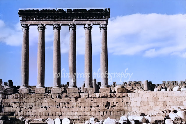
Temple of Jupiter, Beirut - Vintage 1970's 35mm Slide

 The picture below is part of my 35mm slide collection, this one showing the ruins of the Temple of Jupiter, Lebanon. The original picture was taken in the 1970's and can be seen below the restored image.

The picture above was restored using a number of features on photoshop, it can also be seen un-watermarked on my Clickasnap account, click the image and a link should open in another window. The original picture can be seen below.

Clicking on the original picture should open a link in another window to my vintage images album on Clickasnap, all the pictures are dated pre 2000.

Thanks for looking, please take a moment to share and follow me on social media.

The pictures remain the copyright of Colin Green.

Beaumaris Castle, Anglesey - Restored Vintage 35mm 1970's Slide

 The slide below is part of my 35mm slide collection I am currently digitising and restoring - giving new life to, the slide features a picture of Beaumaris Castle, Anglesey, North Wales taken in the 1970's or 80s.


The original picture which can be seen below was restored with a new sky added, the picture was turned in to a black and white image before re-colouring to give the image shown above which can also be seen on Clickasnap. Click the image and a link should open in another window to the version there.


Clicking the image above should open a link in another window to my vintage images album on Clickasnap, featuring pictures before the year 2000.

Thanks for looking, please take a moment to share and follow me on social media.

The pictures remain the copyright of Colin Green.

Saturday, 5 August 2023

Grey Heron on the Rochdale Canal

 I have come across what I believe is they grey heron a number of time over the last few years but this is the first occasion it hasn't flown off before I got a chance to picture it. Today it was simply eying passes by at Lock 1 on the Rochdale Canal when I took my chance to picture the bird.

I took this picture on the 5th August 2023 with a Nikon d3300 camera.

A higher resolution and un-watermarked version can be seen on Clickasnap.

Thanks for looking, please take a moment to share and follow me on social media.

The picture remains the copyright of Colin Green.

Through a Glass, Darkly: Hebden Bridge Railway Station in Negative

 There's something hauntingly beautiful about old photographs, especially when they're presented in a way that flips our perception....