Thursday, 21 September 2023

A Winter Walk Along the Spen Valley Greenway: From the M62 to Cleckheaton

The Spen Valley Greenway, a linear park stretching for roughly 8 miles across West Yorkshire, offers a unique blend of nature, history, and urban convenience. It follows the former route of the Spen Valley Railway, a line that once connected Low Moor to Ravensthorpe. Having already explored the section from Low Moor to the M62, I recently ventured out on a crisp December day to walk the next stretch: from the motorway bridge to the old site of Cleckheaton Central Railway Station. The journey proved to be a quiet, reflective ramble through a landscape transformed.


A Ghost of a Railway

The Spen Valley Railway, originally known as the Mirfield and Low Moor Railway, was a vital artery for the region. It first opened in 1848, with a branch line added a year later. At its peak, it served eight stations, connecting bustling towns like Cleckheaton, Liversedge, and Heckmondwike. Passenger services ceased in 1965, a casualty of the Beeching cuts, and freight traffic ended in the late 1980s. The track bed, left to nature, became a linear wilderness until Sustrans acquired it in 1998, transforming it into the greenway we know today.

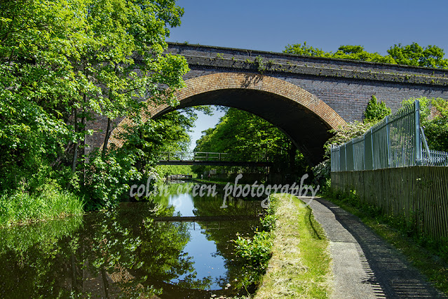
As you walk this section, the history of the line is ever-present. You pass beneath a series of bridges—some rust-stained steel girders, others crafted from brick or stone—that once carried roads and people over the railway. These structures, including the one at Whitcliffe Road, are a powerful reminder of the route’s industrial past, now softened by time and greenery. Occasional remnants of the railway, like old sleepers and signal posts, are still visible if you look closely, adding to the feeling of walking through a living museum.


From M62 to Cleckheaton Central

Starting just north of the colossal M62 bridge, the path narrows and the air grows quiet. This initial stretch feels more enclosed, with thickets of trees and undergrowth creating a natural tunnel. Graffiti-covered concrete walls flank the path, a modern counterpoint to the area's history. As you proceed, the path gently meanders, and the sound of traffic fades into the background.

The walk is surprisingly flat, a testament to the engineering of the original railway. The route's gentle curves take you past open fields and through wooded sections where the winter sun casts long shadows across the gravel track. It’s here you can appreciate the work that went into converting the overgrown trackbed into a smooth, accessible route for cyclists and walkers. You'll see locals out for a stroll or a bike ride, proving the greenway's success as a community resource. Before you know it, you arrive at the former site of Cleckheaton Central Railway Station. There's no grand station building here anymore; instead, you find a paved platform area with benches and railings. It's a poignant space, as if the ghosts of commuters and steam trains still linger. Adjacent to the site is a large supermarket, a stark symbol of how the landscape has evolved. The railway has been replaced by a new form of commerce, but the greenway ensures the corridor itself remains a vital link for the community.


The Future of the Line

It’s interesting to note that there are ongoing discussions about reopening parts of the line. With a population of over 50,000 people along the Spen Valley route and limited rail access, both heavy and light rail proposals are being considered. Walking the greenway, it’s easy to see the potential. The track bed is largely clear and unbuilt upon, offering a tantalizing glimpse of what a restored rail service could be. It's a testament to the foresight of those who preserved this route that such a conversation is even possible.

For now, the Spen Valley Greenway stands as a perfect example of repurposing. It’s a route for commuters, a place for exercise, a corridor for nature, and a living piece of history all in one. Whether you’re a local or just passing through, it's a fantastic way to spend a few hours, connecting with the past while enjoying the present.

Clicking any of the images below should open a link in another window to my Colin Green Photography store on Zazzle.

The M62 Chain Bar Railway Bridge, pictured from the north (Low Moor) side. The line closed here whilst the M62 was constructed, this stretch of track remained open until 1981 as far south as Heckmondwike.

The southern end of the M62 Chain Bar Bridge. Laithe Hill Footbridge can be seen a sort distance down the cutting.

Laithe Hill Bridge.

Whitechapel Road Bridge,

A row of railway sleepers to the north of Cleckheaton, I'm guessing these were placed here as a nod to the greenways railway heritage.


The Spen Valley Greenway on a slight climb up to Whitcliffe Road Bridge. The line started to pen up just beyond the bridge to enter Cleckheaton Central Station and goods yard.

Whitcliffe Road Bridge from the opposite side.

The former trackbed away from Whitcliffe Road Bridge in the direction Cleckheaton Central Station.


The previous 2 pictures show the site of Cleckheaton Central Railway Station, the goods yard was off to the right of the picture and is now a Tesco Supermarket.

The former Cleckheaton Central Railway Station, which first welcomed passengers in 1847, met an untimely end in June 1965, a casualty of the infamous Beeching cuts. While goods traffic continued for a few more years, ceasing in May 1969, the station itself seemed to be on a clear path to demolition. But the story of its end took a truly bizarre and unexpected turn.

In a tale that sounds like something from a mystery novel, British Rail's demolition crew arrived at the site in August 1971, only to find nothing but an empty plot. The station had vanished. It turns out, a different contractor had already "cleared" the site over three weeks, a job for which they were never paid.

This remarkable incident led to a court case in 1972 at Wakefield Crown Court, where a contractor was accused of stealing the station—or, more accurately, its stone, timber, and metal fittings. He claimed he had been hired by an untraceable third party, a story the court believed. He was found not guilty, a victim of a very unusual scam that left him out of pocket but free of a criminal record.

To this day, the case of Cleckheaton Central remains a unique footnote in British history: the only time a railway station was stolen. It's a fittingly strange end for a piece of industrial heritage that has been so beautifully repurposed into the Spen Valley Greenway.

Please take a moment to share this post, follow me on social media, and explore my work on Clickasnap and Photo4Me using the links below. Your support means a lot!


All the images remain the copyright of Colin Green.

Monday, 18 September 2023

Ruskin's View: A Glimpse of the Divine, and a Race to Save It

For a moment, standing at a certain vantage point in Kirkby Lonsdale, you can feel a connection to history, art, and the very soul of the English countryside. This is Ruskin's View, a panorama so stunning it moved one of the Victorian era's most influential figures, John Ruskin, to declare it "one of the loveliest views in England, therefore in the world."

The view, a sweeping vista of the River Lune valley, has been immortalized not only by Ruskin's words but also by the brush of one of Britain's greatest painters, J.M.W. Turner. His painting, an ethereal depiction of the Cumbrian landscape, captures the essence of the scene looking northwards from St Mary's churchyard, with Underley Hall nestled in the distance. The painting itself is a masterpiece, and in 2012, it fetched a price of over £200,000, a sum that puts it well out of reach for most of us.

But the beauty of Ruskin's View is that you don't need a fortune to own it. You just need to be there. And so, on April 4th, 2015, I did just that. With a simple Polaroid is2132 camera, I aimed to capture my own version of the scene, standing where Turner once stood, and taking in the same "naturally divine" landscape that so captivated Ruskin. The photos I took show the view in two directions—the classic northward vista that inspired Turner, and a couple of shots looking south-east, revealing a different, but equally beautiful, aspect of the valley.

The pictures reveal a tranquil scene: the River Lune, winding like a silver ribbon through lush green fields, with scattered trees and distant hills providing a soft, rolling backdrop. The sky, filled with dramatic clouds, is reflected perfectly in the river's calm surface, creating a mirror image of the heavens on earth. The vibrant yellows of daffodils in the foreground add a touch of cheerful colour, hinting at the promise of spring.

But this timeless view is, sadly, under threat. In late 2015, just months after these pictures were taken, Storm Desmond wreaked havoc on the area, severely damaging the banking that supports the footpath and the viewpoint itself. The area has been closed to the public ever since, a stark reminder of nature's power and fragility. The local town council is now in a race against time, trying to raise £1 million to repair the damage and reopen this beloved spot. The thought of this view being lost for good is heart breaking, not just for the local community but for anyone who cherishes the beauty of the English countryside.

Ruskin's View is more than just a pretty picture; it's a historical and cultural landmark, a place that has inspired generations. It's a reminder of a time when people had a deeper, more profound connection to the natural world. As we wait for the restoration efforts to succeed, these images serve as a precious record of what we stand to lose. Let us hope that this cherished corner of the world is not lost to the elements, and that future generations will be able to stand in the same spot, and feel the same sense of awe that Turner and Ruskin once did.

Clicking any of the images below should open a link in another window to my Colin Green Photography store on Zazzle.


The 2 pictures above show the Lune Valley in a south eastern direction.

The picture above and below show the valley in the same direction and from a similar position as Turner's painting.


Please take a moment to share this post, follow me on social media, and explore my work on Clickasnap and Photo4Me using the links below. Your support means a lot!


All the pictures remain the copyright of Colin Green.

Sunday, 17 September 2023

Exploring the Unspoiled North: A Boat Trip Along Ibiza's Coast

When people think of Ibiza, their minds often jump to the vibrant nightlife and bustling beaches of the south. But for those in the know, the true soul of the island lies in its rugged, serene northern coast. I recently had the chance to experience this tranquil beauty firsthand on a boat trip from Portinatx to San Miguel, a journey of approximately four nautical miles that revealed a side of Ibiza many never see.

Sailing out from the charming village of Portinatx, the vibrant blues of the Mediterranean stretched out before us, a striking contrast to the dramatic, ochre-coloured cliffs that hugged the coastline. The sea, a deep, inviting sapphire, was surprisingly calm, and our boat glided effortlessly through the gentle swells.

The journey was a feast for the eyes, with each turn revealing a new and breathtaking vista. The landscape here is wilder and less developed than in the south, with verdant hillsides descending steeply into the sea. We passed by impressive rock formations, like the distinctive, jagged rocks of Calo d'en Calders and the imposing cliffs of Punta de Llevant, their layers of ancient stone a testament to the island's geological history.

One of the most memorable sights was the lonely sea stack of Sa Polleta des Punset. Rising dramatically from the waves, it's a natural sculpture, its craggy peak reaching towards the sky. In the distance, a small boat looked like a toy against the scale of the landscape, a perfect symbol of the tranquility and vastness of this stretch of coastline.

We also got a unique perspective on some of the north's hidden gems, including the beautiful Cala Benirras. From the water, you can truly appreciate the secluded nature of the cove, nestled between rolling hills and rugged cliffs. It's a place that feels like a secret, a world away from the island's more crowded spots. The journey continued past Calo des Porcs and the majestic Cap Blanc, each coastline offering its own unique beauty.

As the sun shimmered on the water, creating a sparkling tapestry of light and shadow, it was impossible not to feel a sense of peace. This was a different kind of Ibiza—one of raw natural beauty, quiet coves, and unspoiled landscapes.

The journey, while only a few nautical miles, felt like a true adventure. It was a reminder that even on an island famous for its energy, there are still places where you can connect with nature and find a moment of profound calm. These photos, taken on July 12, 2014, with a simple Polaroid camera, are a perfect memento of that serene morning spent sailing along Ibiza's magnificent northern coast. If you ever find yourself on the island, I highly recommend leaving the crowds behind and embarking on your own exploration of its wilder side. You won't be disappointed.

Clicking any of the images below should open a link in another window to my Colin Green Photography store on Zazzle.


Benirras Cove

Cala Benirras

Calo d'en Calders

Calo des Porcs

Cap Blanc

Punta de Llevant

Sa Polletta des Punset and entrance to Benirras

Sa Polletta des Punset

Illa des Bosc and the entrance to San Miguel cove.

Please take a moment to share this post, follow me on social media, and explore my work on Clickasnap and Photo4Me using the links below. Your support means a lot!


All the pictures remain the copyright of Colin Green.

The Radical Steps of Kirkby Lonsdale

For those who appreciate a walk with a rich past, the Radical Steps at Kirkby Lonsdale are an absolute must. More than just a simple pathway, these steps are a living testament to a local squabble and a man with a "radical" point of view.

Our journey begins at the top, a spot already famous for its breath taking scenery. Here, near the ancient St Mary's Churchyard, lies Ruskin's View, a panorama so stunning it captivated the Victorian art critic John Ruskin himself. But a few steps away from this well-trodden viewpoint, a different kind of history awaits.

The steps themselves are a story in stone. Built over 200 years ago in 1820, they were commissioned by Dr. Francis Pearson. His goal was simple: to reroute a public footpath that ran through his land. In an era when property rights were fiercely debated, his decision to divert a public right of way met with considerable local opposition. But Dr. Pearson was a man of firm convictions, not just about his land, but in his politics too. His 'radical' beliefs, combined with the controversy over the footpath, led the locals to give the steps a memorable and lasting name: The Radical Steps.

Descending the 86 steps is a journey back in time. The steps are a beautiful, if rugged, part of the landscape, worn smooth by countless feet over two centuries. They are steep and uneven in places, a physical challenge that reminds you of their age and the terrain they conquer. As you make your way down, you're flanked by ancient stone walls, cloaked in moss and ivy, and railings that seem to belong to a bygone era. The air is cool and damp, filled with the scent of earth and the sound of the nearby river.

The descent culminates at the banks of the River Lune, a peaceful and scenic reward for your efforts. Here, the river flows serenely, its surface reflecting the sky and the surrounding trees, a perfect contrast to the strenuous path you just took. Looking back up at the steps from the riverbank, you can truly appreciate their steepness and the engineering feat they represent.

While the beauty and history of the Radical Steps are undeniable, it's important to note their accessibility. The steepness and uneven nature of the steps make them unsuitable for those with walking difficulties or disabilities. They are a true hill walk, a physical challenge for the able-bodied and a reminder that some of the best views require a little effort.

These photos, taken on a crisp April day in 2015, perfectly capture the steps' character. They show the verdant surroundings, the rugged beauty of the stone, and the varying perspectives you experience on your journey down to the River Lune. They serve as a wonderful memento of a unique historical landmark, a place where a man's convictions literally shaped the landscape.

So next time you're in Kirkby Lonsdale, take a moment to explore the Radical Steps. You'll not only be treated to a fantastic view, but you'll also be walking in the footsteps of history.

The pictures below were taken on the 4th April 2015 with a Polaroid is2132, clicking any of them should open a link in another window to my Colin Green Photography store on Zazzle.

The wall that runs the length of the stairs means that quite often the steps can be damp and slippery even on dry days, the wall blocking sunlight and wind from drying the steps.


The River Lune is seen running along the bottom of the picture, the steps leading down to a path the runs alongside the river towards Devil's Bridge.

Please take a moment to share this post, follow me on social media, and explore my work on Clickasnap and Photo4Me using the links below. Your support means a lot!


All the pictures remain the copyright of Colin Green.

Saturday, 16 September 2023

The Whitacre Mill Viaduct

Nestled in the green landscape of Deighton, near Huddersfield, the Whitacre Mill Viaduct is a silent witness to a bygone era of railway expansion. This impressive, disused railway bridge stands as a testament to the ambitions of the London & North Western Railway and its plan to connect Huddersfield with the Barnsley coal mines via the Kirkburton Branch Line.


A Bridge with a Story

Construction on the viaduct began in March 1865. Despite a partial collapse in February 1866, the viaduct was completed in time for the line's opening in October 1867. Although the grand plan for the railway was never fully realized, the viaduct served a short section of the line until its final closure in December 1971. Today, it stands as a monument to its industrious past, crossing the Huddersfield Broad Canal, the River Colne, and the valley below.


A Path Less Traveled

While the viaduct is largely overgrown on one side, it offers a unique walking experience from the Deighton side. Although challenging to navigate, the path provides a sense of adventure and a connection to the area's history. There are plans by Kirklees Council to transform the viaduct into a greenway, much like the nearby Bradley Viaduct, which would open this piece of history to a wider audience. Until then, it remains a secluded and beautiful spot, waiting to be rediscovered.

The pictures below were taken on the 27th May 2023 with a Nikon d3300.

The viaduct crossing the Huddersfield Broad Canal.

The top of the viaduct is supposed to be blocked off, I took this from the access point that has been removed. You can get approx. 2/3 of the way across before the bushes become to thick to pass, walking along the top of the wall would have allowed me to get further but I'm not great with heights, so I thought better of that idea.

Huddersfield Broad Canal pictured from the viaduct, Longlands Lock number 4 is just visible at the top of the picture.

The Huddersfield Broad Canal from Whitacre Mill Viaduct. The picture was taken in the direction of Huddersfield.

The overgrown former track bed looking towards the fence off access. The hole in the fence can be seen to the right of the picture if you follow the wall to the trees.


Please take a moment to share this post, follow me on social media, and explore my work on Clickasnap and Photo4Me using the links below. Your support means a lot!'


All the pictures remain the copyright of Colin Green.

Copley: A Walk Along the River Calder

A stroll along the River Calder at Copley offers a fascinating glimpse into a landscape in transition. These images, captured in March 2015, show a stretch of the river that has undergone significant change. The area, once dominated by industrial and natural spaces, has since been redeveloped with new housing and industrial units, connected by a new bridge and roads.


Echoes of the Past

The riverbanks at Copley once bustled with activity. The Sterne Mills, a site with a history of milling dating back to the 18th century, stood on the north bank. By the turn of the millennium, the site was unoccupied, but its legacy remains. The weir that once powered the mill and a nearby sluice gate are still visible, a quiet tribute to the area's industrial past.


A Changing Landscape

The river crossing at Copley has also evolved over time. What was once a simple fording point was later a wooden bridge, then a single-track concrete structure from 1914, before being replaced by the current, modern bridge. This evolution mirrors the larger changes in the area, where new developments now sit alongside historic remnants. This blend of old and new makes the Copley Valley a unique place to explore.

The pictures below were taken on the 8th March 2015 with a Polaroid is2132 camera, clicking on any of them should open a link in another window to my Colin Green Photography store on Zazzle.

The former sluice gate is all that remains of the mills that once occupied the site.

The weir and modern bridge crossing, the 1914 bridge abutment can just be seen before the metal banking, behind the watermarked col.

The river passing Copley Village, the stone wall to the pictures left is all the remains of Edward Akroyd's Copley Mill which was demolished in 1974, the site is now covered by housing.

This picture was taken from the side of Copley Playing fields looking towards the bridge and wier.

Taken from the south bank, this path used to pass Sowerby Bridge Sewage Works, the site is now occupied by industrial units. I was told once that the river used to be navigable past this point until the canal came and weirs were built to power the mills.

The river again pictured here to the west of Sterne Mills Bridge, the north bank pictured across the river is now covered by housing on what was once considered a flood plain. Just about visible through the trees is the Halifax Bank's Copley Data Centre, opened in the mid 1980's the centre is earmarked for complete closure in 2025.

Please take a moment to share this post, follow me on social media, and explore my work on Clickasnap and Photo4Me using the links below. Your support means a lot!


All the pictures remain the copyright of Colin Green.

Friday, 15 September 2023

Todmorden Town Hall: A Symbol of Unity and History

Located in the heart of Todmorden, the magnificent Todmorden Town Hall stands as a testament to the town's rich history and a symbol of its unique identity. This stunning neo-classical Grade I listed building is not just an architectural marvel but a landmark with a fascinating story.


A Tale of Two Counties

One of the most remarkable things about Todmorden Town Hall is its origin. It was intentionally built across the historic county boundary of Lancashire and Yorkshire, a deliberate choice to help unite the rivalries between the two areas. Although the boundary was later moved in 1888 to place the entire town within Yorkshire, the hall's dual heritage remains a central part of its story.


A Grand Opening

The hall's construction was a journey in itself. Originally designed by architect James Green, work was halted in the 1860s due to legal and financial challenges. The project was revived when the prominent Fielden family purchased the land and hall in 1866. They appointed John Gibson of Westminster to redesign the building, and it was finally completed and opened to the public on April 3, 1875, at a cost of £54,000.


A Timeless Landmark

Todmorden Town Hall's striking design, with its grand columns and intricate details, is a sight to behold. It has been a central part of the community for over a century, hosting countless events and serving as a focal point for the town. Whether you're a history buff or an architecture enthusiast, this iconic building is a must-see landmark in West Yorkshire.

The pictures below were taken on the 28th November 2013 with a Samsung Galaxy Tablet, clicking any of them should open a link in another window to my Colin Green Photography store on Zazzle.


This was taken from the grounds of St Mary's Church, the A646 Halifax Road heading off and the A646 Burnley Road going off towards the left of the picture.


The Yorkshire Bank Branch pictured here was closed in 2017, plans to convert the building to a branch of McDonalds were ongoing in 2019 prior to the Covid 19 Pandemic, these seem to have been abandoned and the building remains unused as of September 2023.


The front of the town hall, St Mary's Church is pictured to the left of the hall.


The rear of the building, again St Mary's Church is visible this time to the right of the hall.

The waterway that once separated the counties of Lancashire and Yorkshire ran underneath the hall, people dancing in the halls ballroom could start a dance in one county and finish in the other.

Please take a moment to share this post, follow me on social media, and explore my work on Clickasnap and Photo4Me using the links below. Your support means a lot!


All the pictures remain the copyright of Colin Green.

Tuesday, 12 September 2023

The Lord Nelson Inn: A Historic Gem in Luddenden

Nestled in the heart of the picturesque village of Luddenden, West Yorkshire, the Lord Nelson Inn is more than just a pub—it's a living piece of history. Situated on High Street, it's the village's last remaining pub, making it a beloved gathering spot for locals and a well-regarded destination for visitors.


A Pub with a Past

The building's story begins long before it became a public house. Constructed in 1634 as a home for local landowner Gregory Patchett, it was originally called Newhouse. By the mid-1700s, it had been converted into a pub, first known as the White Swan. Its current name, the Lord Nelson, was adopted in 1805 in honor of the British naval hero following the Battle of Trafalgar, and it has kept that name ever since.


More Than Just a Public House

The Lord Nelson Inn has a storied past that goes beyond serving drinks. From 1776 to 1917, it housed the Luddenden Library. One of its most famous patrons was Branwell Brontë, the brother of the celebrated Brontë sisters, who was often seen at the pub during his time working at the nearby Luddendenfoot Railway Station. The inn has also served as a stand-in for the local St. Mary's Church for various functions, further cementing its role as a central hub of the community.

With its rich history and cosy atmosphere, the Lord Nelson Inn is a must-visit for anyone exploring the charming countryside of West Yorkshire. Have you ever visited a pub with such a fascinating history?

The 2 pictures below are all that remains of a set of 6 I took around the pub, they were taken on the 13th October 2013 with a Samsung Galaxy Tablet. Clicking on them should open a link in another window to my Colin Green photography store on Zazzle,


I took this from the garden - seating area at the junction of Old Lane and High Street.


I took this picture from the churchyard of St Mary's, the high building directly behind the Lord Nelson used to be the village school known as St Mary's Old School, it was closed in 1993 and is now a private residence.

Please take a moment to share this post, follow me on social media, and explore my work on Clickasnap and Photo4Me using the links below. Your support means a lot!


All the pictures remain the copyright of Colin Green.

The Legacy of Stone: A Look at St Mary's Church, Cottonstones

Tucked away in the beautiful, hilly landscape of West Yorkshire, St Mary's Church, Cottonstones stands as a proud landmark, overlooking...