Wednesday, 27 December 2023

Rochdale Canal, Rose Grove Bridge 3 to Bridge 1a

The Rochdale Canal Rose Grove Bridge (3) to Tower Hill Bridge (1A) is an approximately 1-mile-long flat section of the waterway. Along this stretch, you'll pass Rose Grove Bridge and Hollins Tunnel, also sometimes known as Cemetery Tunnel. I have no idea why it is known as this, as Sowerby Bridge Cemetery is on the opposite hillside. After the tunnel, the canal curves towards Sowerby Bridge, passing under the Co-Op Bridge and Tower Hill Bridge.

After the closure of the Rochdale Canal in 1952, the canal came to an abrupt end just before reaching Tower Hill Bridge and was infilled through to the modern-day exit of Tuel Lane Tunnel adjacent to Lock Number 2.

These pictures were taken on the 10th April 2022 with a Nikon D3300, they can be seen below and on Clickasnap un-watermarked. Simply click any image to see the Clickasnap version in another window.

These two pictures show both sides of Bridge 3 High Royd.


These two pictures show the stretch of Canal towpath between Rose Grove, High Royd Bridge and Hollins Tunnel.


Inside Hollins Tunnel.

Hollins Tunnel entrance on the Sowerby Bridge side.

The canal curbing towards Sowerby Bridge, the Co-Op bridge visible crossing over the canal. The bridge provides acces to Hollins Mill Lane from the Industrial Road area of Sowerby Bridge, but does not give any access to the canal.

The canal underneath Bridge 1A. In 1952 the canal was infilled from just beyond the arch, the bridge was also known as Tuel Lane Bridge until the road that crossed over it was rerouted and then it was changed to Tower Hill Bridge. The tower block is Ladstone Towers, built when large areas of low quality housing around the area was demolished in the mid 1960's.

Thanks for looking please take a moment to check out my Zazzle stores, photo4me portfolio, andshare on social media.

All the pictures remain the copyright of Colin Green.

Sunday, 24 December 2023

Devil's Bridge, Kirkby Lonsdale

Devil's Bridge was once the main road crossing over the River Lune but has been closed to traffic since 1932. It is thought to date from 1370 and was built by the monks of St. Mary's Abbey, York. The bridge used to be popular for tombstoning, with the deep pools underneath the main arch allowing people to jump without much threat of injury. This was outlawed a few years ago, but the bridge is still popular in the summer months as a destination for bikers riding up through the Yorkshire Dales. It was replaced as the main crossing over the river by the nearby Stanley Bridge. The bridge is Grade I listed.
 
Legend says that the Devil built the bridge in exchange for the first soul to cross after completion. A woman threw bread across for her dog to chase, so that the devil felt tricked as the dog was the first soul to cross the completed bridge.
 

The pictures were taken on April 4, 2015, using a Polaroid IS2132 bridge camera. They have previously been posted but the ones below were reworked recently for my Zazzle Store and Photo4Me wall art portfolio. They can also be seen on my Clickasnap account via the link in the side panel.

Clicking the image will open a link in another window to my Kirkby Lonsdale collection on Zazzle, the image can be transferred to a number of different products to the ones already offered, including wall art, furnishings, cups, watches, clocks, phone and tablet cases. Please take a moment to have a look.

Clicking this image above and below should open a link in another window to the Photo4Me listing for each picture..


All 4 images can be purchased on various products of your choosing from my Zazzle store, the middle 2 images can also be purchased as wall art from Photo4me.

Thanks for looking, please take a moment to share and follow me on social media.

All the pictures remain the copyright of Colin Green.

Please take a moment to check out my stores on Zazzle, Photo4me and Clickasnap portfolio's.
 

Saturday, 16 December 2023

Fiery Sky at the Ruins of the Church of St Thomas a Becket, Heptonstall

The picture below is the result of a little tinkering with replacing a washed-out overcast sky in a picture I took in November 2013 with a more adventurous sunset-type sky.

The picture shows the inside of the ruined church of St. Thomas a Becket, Heptonstall, a church built on the site of an earlier one in the 15th century. The church was damaged beyond repair in the 19th century and replaced by the Church of St. Thomas the Apostle, which occupies the same grounds as its predecessor.

I took the original pre-edited version of the picture on November 16, 2016 with a Samsung Galaxy Tablet; it can be seen un-watermarked on Clickasnap by clicking the image. The link opens in another window.

Thanks for looking, please take a moment to share and follow me on social media. You can also check out my Zazzle stores via the links in the sidebar. I also have a sales profile on Photo4Me.

The picture remains the copyright of Colin Green.

Saturday, 9 December 2023

The Ribblehead Viaduct - Photo4me

The Ribblehead Viaduct is a set of pictures taken in April 2015 using a Polaroid IS2132 digital bridge camera. The impressive structure is somewhere I had wanted to visit for a while, and I was in nearby Kirkby Lonsdale when I got the chance. The viaduct is also known as Batty Moss, and it is located approximately 13 miles north of Settle and 73 miles south of Carlisle on the famous Settle to Carlisle Railway. There is the Ribblehead Railway Station adjacent to the viaduct, which is a train ride of approx. 1 hour and 20 minutes from Leeds Railway Station, and the B6255 road linking Hawes with Ingleton passes the viaduct.

The pictures below are a set I have recently re-edited for inclusion in my Photo4Me portfolio. Clicking any image will open a link to the listing in another window.


All the pictures can be purchased on Photo4Me or just enjoyed her and on my Clickasnap profile, They will shortly be offered in various products at my Colins Picture This Zazzle store.

The history of the viaduct below is taken from my earlier post on the Ribblehead Viaduct.

The viaduct was designed by engineer John Sydney Crossley. The first stone was laid on October 12, 1870, and the last in 1874. One thousand navvies built the viaduct and established shanty towns on the moors for themselves and their families. They named the towns after Crimean War victories, well-to-do districts of London, and biblical names. There were smallpox epidemics and deaths from industrial accidents. Around one hundred navvies were killed during its construction. There are around 200 burials of men, women, and children in the graveyard at Chapel-le-Dale dating from the time of its construction. The church has a memorial to the railway workers.
The line over the bridge was opened to goods traffic on August 3, 1875, but passenger trains did not commence running until May 1, 1876, following approval of the works by Colonel F. H. Rich, an inspecting officer of the Board of Trade.
In 1964, several brand new Humber cars landed on the ground after being blown off their waggons while being carried over the viaduct on a freight train.
 
Ribblehead Viaduct is 440 yards (400 m) long and 104 feet (32 m) above the valley floor at its highest point. It is made up of twenty-four arches of 45 feet (14 m) span, with foundations 25 feet (7.6 m) deep. Every sixth pier is 50% thicker to mitigate against complete collapse should any pier fail. The north end of the viaduct is 13 feet (4.0 m) higher in elevation than the south end, leading to a gradient of 1:100. 1.5 million bricks were used in the construction, and some of the limestone blocks weigh 8 tonnes each.
 
Ribblehead Viaduct is the longest on the Settle-Carlisle Railway. Ribblehead railway station is less than half a mile to the south, and to the north is the Blea Moor Tunnel, the longest tunnel on the line. It is near the foot of Whernside.
The Settle-Carlisle Line is one of three north-south main lines, along with the West Coast Main Line through Penrith and the East Coast Main Line via Newcastle. British Rail attempted to close the line in the 1980s, citing the fact that the viaduct was unsafe and would be expensive to repair. A partial solution was to single the line across the viaduct in 1985, preventing two trains from crossing simultaneously. A 30 mph speed limit is also in force. The closure proposals generated tremendous protests and were eventually retracted. The viaduct, along with the rest of the line, was repaired and maintained, and there are no longer any plans to close it.
Two taller viaducts on the route are Smardale Viaduct at 131 feet (40 m) high and near Crosby Garrett, and Arten Gill at 117 feet (36 m).
 
In 2016, the line and viaduct carried seven passenger trains from Leeds to Carlisle per day in each direction, plus periodic long-distance excursions, many hauled by steam locomotives. Regular diesel-hauled heavy freight trains also use the route to help reduce congestion on the West Coast Main Line. Colas Rail operates a timber train most Friday afternoons, which passes over the Viaduct when it departs its yard opposite Ribblehead railway station. The combination of the rarely seen timber train and the British Rail Class 56 locomotives used to pull the train has built quite an enthusiastic following. Another regular traffic flow to use it is the limestone aggregate train from Arcow quarry sidings (near Horton-in-Ribblesdale), which runs to various stone terminals in the Leeds and Manchester areas on different days. This has to be reversed in the goods loop at Blea Moor signal box (north of the viaduct) because the connection from the quarry sidings to the main line faces north.

Thanks for looking, please take a moment to share and follow me on social media.

All the pictures remain the copyright of Colin Green.

Sunday, 26 November 2023

Pickle Bridge Railway 2014

The Pickle Bridge Railway was a line through the outskirts of Brighouse connecting Bradford with Huddersfield. The line opened in 1881 and remained in use until 1952, when it closed due to subsidence. The two stations along the route were closed many years before the line's full closure. There is quite a lot of evidence of the line between Clifton Road and Pickle Bridge, Wyke. Sadly, between Clifton Road and Anchor Pit, not much exists.
 
The line split from the Calder Valley Line at Pickle Bridge Junction, which was between the stations of Norwood Green (closed 1953) and Lightcliffe (closed 1965). It then crossed the 22 arch (now 8 arches; the northern 14 were demolished in 1987 due to subsidence) Wyke (Red Lion) viaduct before arriving at Baliff Bridge station (1881–1917). The line then carried on southwards over the still-standing 5-arch Thornhills Viaduct before crossing another now-demolished viaduct at Clifton. The three-arch Clifton viaduct immediately led to Clifton Road Station (1881–1931). Beyond Clifton Road, the line then crossed the A644 Wakefield Road and River Calder before joining the Caldervale Line at Anchor Pit Junction between Brighouse Station (1840–1970, closed and demolished 1970; reopened 2000) and Cooper Bridge Station (1840–1950).

I walked the route on two separate occasions, the first covering the former track layout from the site of Clifton Road Viaduct until I reached an abandoned railway bridge standing alone in the middle of a field between Thornhills Beck Viaduct and Birkhouse Road, Bailiff Bridge. This set was taken on March 30, 2014.
 
The remains of Clifton Road Viaduct, the station occupied a spot along the wall pictured with the dirt track to the left the main access road.

Former trackbed pictured between the remains of Clifton Road Viaduct and Thornhills Beck Viaduct.

The top of Thornhills Beck Viaduct, this was the southern side and was gated off as can be seen preventing access any further.

Thornhills Beck Viaduct, opened up I think it would make an interesting footpath - cycleway.

Another of Thornhills Beck Viaduct


These last 2 show an abandoned bridge in the middle of a low cutting in what seemed to have become a farmers field. Looking at the surrounding land and historic maps I can see no reason for it's existence as their were alternative crossings over the railway nearby in both directions.

The second set of pictures were taken on the 25th May 2014, starting at the bridge above they show the remains of the line up to the end of Red Lion (Wyke) Viaduct.


The Pickle Bridge line crossing over Birkhouse Lane, Bailiff Bridge

The line's remains at Bailiff Bridge, the town's former station used to occupy a spot to the right of the picture behind the trees.

All that remains of the bridge that crossed Lower Wyke Lane, Houses now occupy the former trackbed to the left of the picture.

The bridge that crossed over Bradford Road has been removed, leaving only the abutments as a reminder the railway passed here.

The Red Lion or Wyke Viaduct crossing over a small access lane off Bradford Road.

The top of Wyke - Red Lion Viaduct, I don't remeber climbing up to the top but I must have as the picture here proves I did. The end of the viaduct was probably just beyond the trees,

Wyke - Red Lion Viaduct. The crossing suffered badly from subsidence resulting in a much reduced speed limit during its years of operation. The situation was so bad that by the 1980's permission was sought to demolish part of the Grade II listed Viaduct.

This partially overgrown bridge stands to the northern end of the demolished part of Wyke - Red Lion Viaduct, I'm not sure if it was separate or part of that structure.

Clicking any picture will open a link to the version on Clickasnap.

Thanks for looking, please take a moment to share and follow me on social media.

All the pictures remain the copy right of Colin Green.

You can check out my Zazzle stores below, clicking either image will open a link to that store.


Both stores offer a collection of products from bags to clocks, postcards to posters, mouse mats to tablet covers and if you like the design you can transfer it to hundreds of products of your choosing. Please take a moment to have a look.

Monday, 20 November 2023

Heptonstall Randoms Around Towngate July 2020

The village of Heptonstall occupies a small spot on the hill overlooking the Calder Valley and Hebden Bridge, West Yorkshire. The town is home to approximately 1400 people, and traditionally, the village's industry was hand-loom weaving. The village is a favourite spot with hikers and has featured in a number of TV shows in recent years, including the recent Shane Meadows drama The Gallows Pole, a story about the Cragg Vale Coiners, whose leader, "King" David Hartley, is buried in the churchyard.

The pictures below were taken at various locations around the town and don't feature the usual locations shown: the Wesleyan Chapel, the Ruined Church, and its replacement. I have posted my pictures of them in earlier posts. They were taken using a Nikon D3300 on July 11, 2020.

The phone box found towards the lower end of Hetonstall is now I am told used as a library by the local community.

Towngate is the main route through the centre of the village.

The village's post office.

34 Towngate.

41A Towngate. The passge to the right leads to the former grammar school and museum and runs past the churchyard.

The grammar school and museum buildings, the fence to the right surrounds the lower part of the churchyard.

Clicking any image should open a link to the version on Clickasnap.

Thanks for looking, please take a moment to share and follow me on social media.

All the pictures remain the copyright of Colin Green. Clicking the images below should open a link in another window to my Zazzle Stores.


Sunday, 12 November 2023

Belle Vue Stadium, Wakefield Artwork

Belle Vue is a sports stadium in Wakefield, West Yorkshire. It first opened in 1895 and is currently home to Wakefield Trinity RLFC and, since 2023, Wakefield AFC. The picture shows the East (main) Stand and the Benidorm Stand, so named due to It's resemblance to the hotels found in the Spanish resort.

The main stand has been demolished since I took the original picture and is currently in the process of being rebuilt. The club, having struggled for many years to move grounds, has finally proceeded with a scheme to redevelop Belle Vue.

The artwork can be seen un-watermarked and full size on Clickasnap, it can also be purchased on various items from my Zazzle Store.


Clicking the image should open a link to the un-watermarked, higher resolution version on Clickasnap. The image is also listed for sale in my Colins Picture This Zazzle Store, link below, it can be purchased as a number of items including mugs, poster, bags and many other formats.

Thanks for looking, please take a moment to share and follow me on social media.

The picture remains the copyright of Colin Green.


Saturday, 11 November 2023

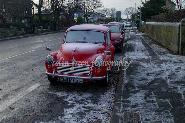
Vintage Morris 1000

The Morris Minor 1000 was a British car in production from 1956 until 1971. During this period, over 850,000 were built. The car pictured is a 1967 model and was parked up outside St. John the Evangelist Church, Bierley Lane, Bradford.

The pictures were taken on the 10th December 2022 with a Nikon d3300.


Clicking any image should open a link in another window to the un-watermarked, higher resolution version on Clickasnap.

Thanks for looking please take a moment to share and follow me on social media, also you can check out my stores on Zazzle by clicking the pictures below, links open in another window.

My Calderdale Unframed Zazzle store features a number of products with images of Calderdale central to the theme.

My Colins Picture This Zazzle store features images on products with various themes and places.

I hope in time to feature all the pictures I have displayed on here over the years.

All the pictures remain the copyright of Colin Green.

Saturday, 4 November 2023

Asquith Bottom Mill, Sowerby Bridge April 2017

I previously pictured some of Asquith Bottom Mill in 2013 and posted these pictures earlier, the pictures below were taken in April 2017 with a Nikon d3300.

Asquith Bottom Mills is a mixed-use industrial estate at Sowerby Bridge, West Yorkshire, built up around a former (depending on the era) carpet, wire, and woollen mill. The mill was originally built by William Edlestons, and I still remember the red neon sign with their name across the roof during the 1980s (sadly now gone). I believe they closed during the late 1980's and early 1990's.

The pictures below can also be seen un-watermarked on Clickasnap; simply by clicking on any image, a link should open in another window.

The front of the mill used to feature a bowling green where the cars were parked across the River Ryburn. The top of the building used to feature a WM Edlestons sign lit up in red.

The doorways used to provide access so goods could be moved up and down, but the hoist support is still sticking out of the building.


This picture was taken from the Norland hillside towards the back of the building. I don't imagine other than for safety checks that fire escape has been used in many years.
 
Clicking any image should open a link in another window to the version on Clickasnap.
 
Thanks for looking; please take a moment to share and follow me on social media.
 
All the pictures remain the copyright of Colin Green.

Discovering Luddenden: A Timeless Yorkshire Gem

Nestled in the heart of the Calderdale valley, just a stone's throw from Sowerby Bridge, lies the enchanting village of Luddenden. If yo...